September Summer Sizzle - Unprecedented Heat In Parts Of New England
BOSTON (CBS) - It's been a weird year.
At times people have complained about heat (February). Other times it's been rain (July). Sometimes cold (March). All in fits and spurts. Many locations saw their warmest temperatures ever recorded so early in the year during that late February blast of warmth, where towns topped 70 degrees and we even had a tornado touch down in the Berkshires. Albany, NY and Burlington, VT were a couple of cities that saw their warmest temperatures on record for February. Then we plunged into a chilly spring stretch and the rains poured down. All of the sudden it was August and it felt like fall. And now it's summer in late September. Weather rarely follows the progressive 'ideal' march of the seasons we have in our minds.
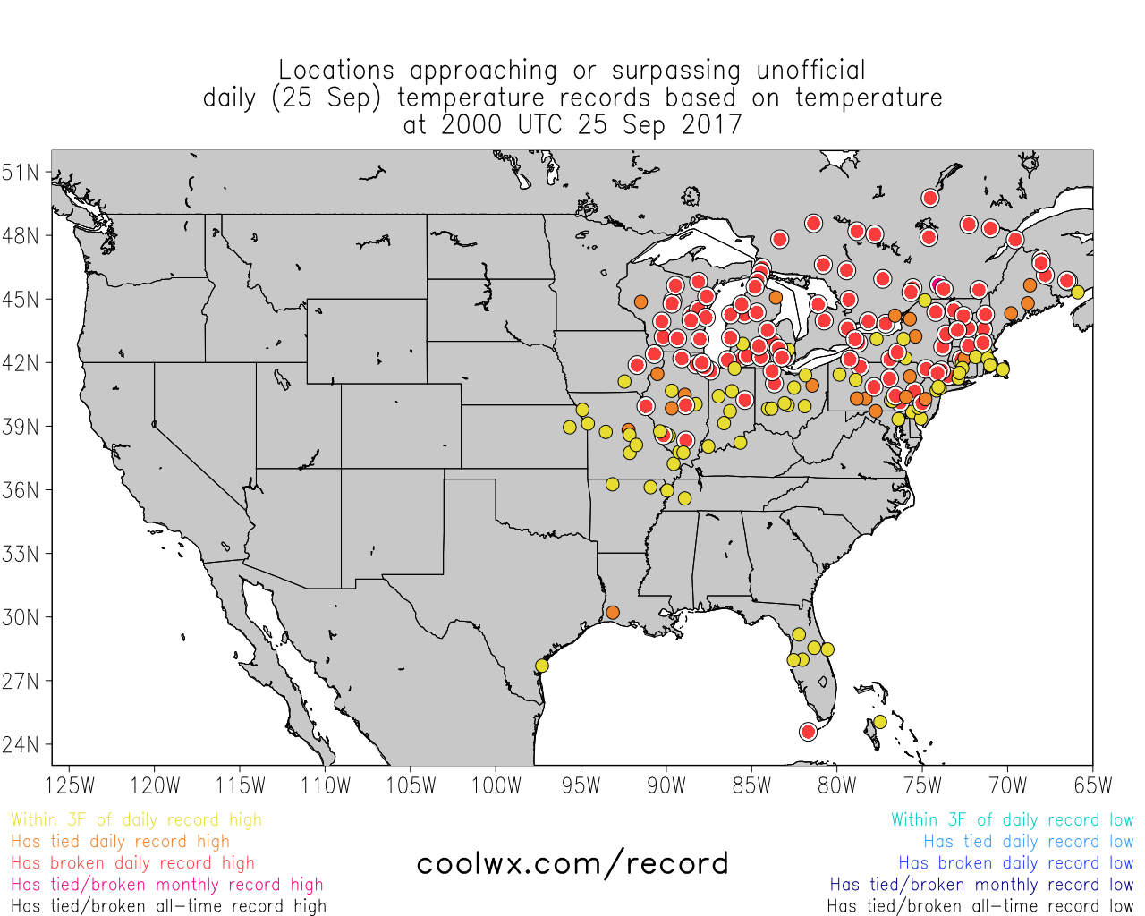
Numerous record highs set Monday, including 90s well north into southeastern Canada. Source: coolwx.com/record
What's the deal right now? Exceptional heat for this time of the year - particularly for northern New England. Burlington, VT had never hit 90F so late in the year until Sunday, when it hit 91 degrees (records date to the late 1800s). Then it hit 92 on Monday, breaking that record. And it might do exactly the same on Tuesday for a full official heat wave. Oddly enough, Burlington has had only six days top 90F all year, and none of them were during astronomical summer!
Mainers are sweating it out as well. Even all the way up in Caribou, bub. They've had three straight days in the 80s, which has never happened during their period of record. Tuesday will bring a fourth day, extending that record. The 88 degrees seen on Monday was also the hottest on record it has been so late in the season. Not exactly prime foliage viewing conditions.
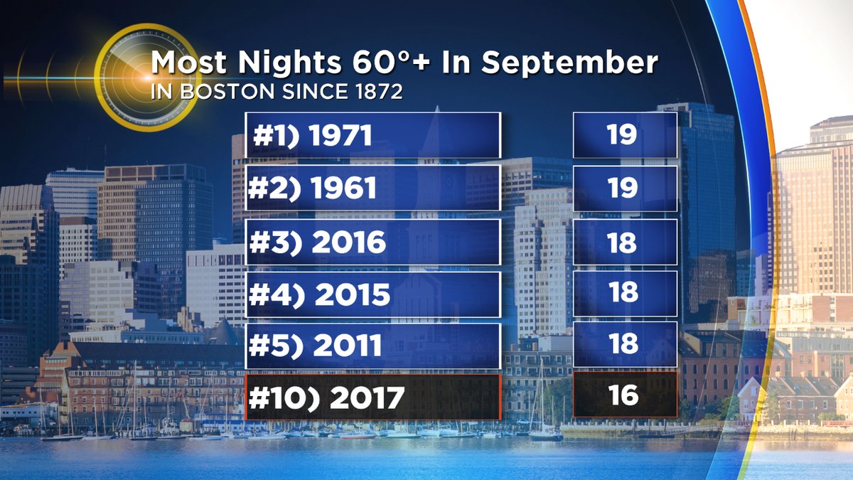
We'll be making a run at a record for lack of cool crisp nights in the Boston area. Dating back to 1872, the most nights which have failed to drop below 60F during September is 19, set on two different years. We're currently at 16. Tuesday and Wednesday are muggy locks. So it comes down to Thursday to tie the record. There's a chance Boston holds on to 60F through 1am, and if that's the case we'll tie. If it falls into the 50s before then, it's 2nd place. Either way, muggy air and mild temperatures have dominated these September nights in 2017. You'll also notice many of the most mild years on record have all occurred in the past several years.
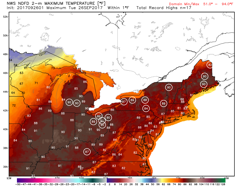
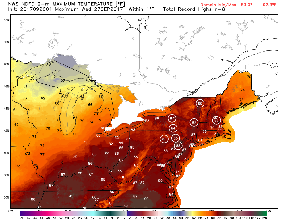
More record highs ahead for Tuesday and Wednesday
Inland areas will continue to see summer warmth through Wednesday before it comes to a halt on Thursday. We're watching a cold front that will accomplish two purposes. First off, it brings in much more seasonable, drier air as dew points crash into the 40s. Secondly it will push Maria out to sea, limiting impact here in New England to some rough surf on south facing beaches this week. Not much to complain about on either account!
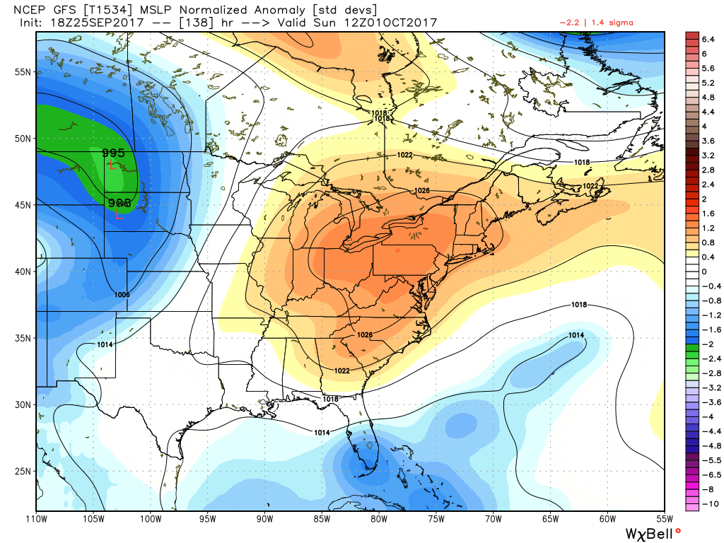
High pressure crests over the Northeast this Sunday, and this time around it's a cool high. Temperatures should top out at that autumn 'sweet spot' near 70F
This step-down to more typical late September/early October weather will last but a few days. Friday's highs will stay in the 60s for most of the area, as will Saturday's. A weak impulse will likely bring a few scattered showers on Saturday but definitely not a washout scenario. Can even wear your fall jacket for a change. It's Sunday that we get the weather we've really been craving. Highs near 70F, lots of sunshine, light winds, high pressure overhead, low humidity. We really need it for our local fall businesses after two straight hot weekends. Not many thinking mums, apple picking, or hay rides when it's humid and in the 80s! Sunday should offer the perfect day to soak in some of these fall favorites.
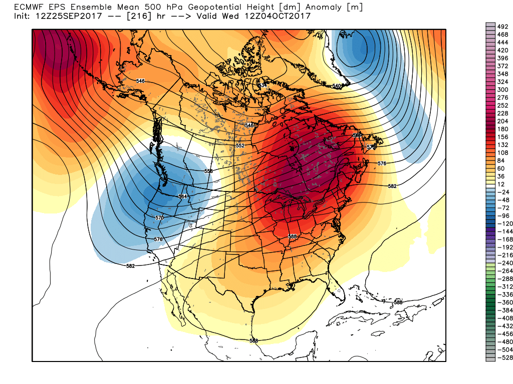
Full-on October torch pattern setting up after the weekend with widespread warmth returning to the east
Sadly for the cool weather lovers but to the joy of warm weather seekers, this will not last very long. A huge anomalous ridge is expected to build once again across the Midwest, Northeast, and into southeastern Canada. This may bring another surge of record heat, especially for inland areas away from the coast. It looks like the core of this heat may again focus on the Midwest and interior New England, but we should be plenty warm here locally. Another stretch of 70s and 80s may carry us right through mid-October, so we're not expecting any sustained cool weather anytime soon. It also means the growing season (and mosquito season) is likely going to go deep into autumn this year. I'm not seeing anything remotely close to widespread frost on the horizon.


