Crisp Air, Don't Care? Then The Weekend Forecast Is For You
Find Eric Fisher on Twitter and Facebook
It's pretty hard to get into the autumn spirit when temps are warm enough for the 4th of July. The only things that will distinguish midsummer from the fall equinox on Thursday is the sun angle and length of daylight. Highs will jump well into the 80s (fortunately without much humidity) and it will be an excellent beach day to kick off the new season. But if you're growing weary of the summer slog (Disclaimer: I'm not) then you're going to love the forecast ahead. The cool and crisp air you envision on the doorstep of October is about to make an appearance.
What we're keeping tabs on is a backdoor cold front that will get forced down across New England on Friday. The timing is still a little uncertain locally, though you can bet on the cool air invading rather quickly for the Seacoast and Cape Ann down into Boston. By the evening, the front should be through the entire area and northeast winds will bring in that cool ocean air from the Gulf of Maine. That means a midday in the 80s for some will see a 20 degree drop by dinner! So definitely plan accordingly - it's a day of changes in both temperature and sky cover. The front will be accompanied by clouds and some scattered showers/a rumble or two. That's all we have for rain in the forecast through Tuesday PM.
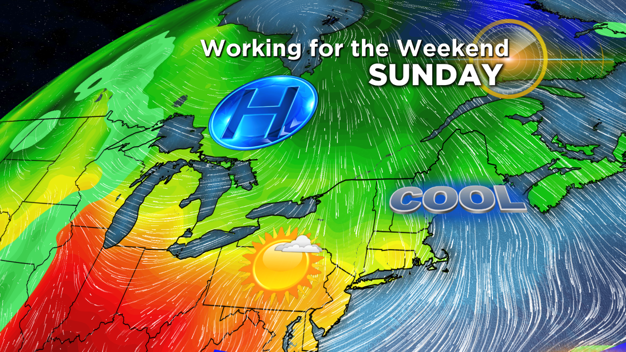
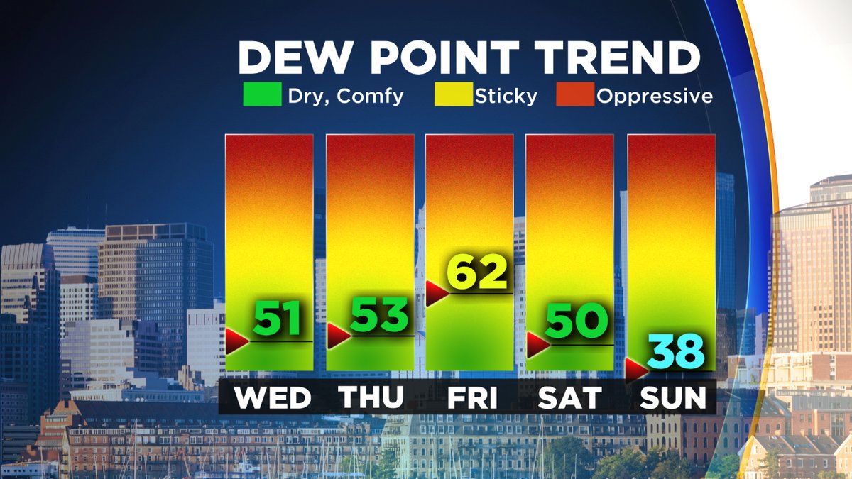
Then for the weekend, it's GAME ON autumn. A large area of high pressure builds in, bringing the coolest air of the season so far. It's not a direct, long-lasting blast - shunted toward eastern New England with the core of it quickly exiting out into the Atlantic. But it's enough to keep us out of the 70s for several days, which hasn't happened since a rainy stretch in early July. Plus that air in early July wasn't dry and refreshing, even if the temperatures were cool. For this blast we'll be getting dew points all the way down into the 30s on Sunday! A major change considering we had dew points near 72 on Monday/Tuesday, which is more fitting for Florida this time of year.
The sky cover will be a little tricky this weekend, as guidance is showing some low-level moisture around on Saturday. I think there's the potential for some low cloudiness to hang on for a while. Couple that with a cool breeze out of the northeast, and it will have that October kind of feel. It should feel especially chilly because of our recent warm weather, since change is always relative! As drier air works into the column, we should see more sunshine on Sunday. A cold upper-atmosphere should produce some cumulus clouds dotting the midday and afternoon sky on the coolest day since mid-May.
Getting 'clipped' by the core of the cold Sunday into Monday. Much cooler air here in New England than across the Midwest where the heat will still be on. Source: Weatherbell
Looking into Sunday night, winds should begin to relax as the pressure gradient weakens. Since we'll have a chilly air mass in place, this could set the stage for patchy frost by Monday morning. It will come down to whether or not winds completely go slack, and the highest probability of any frost would be in the typical cold spots of central/western Mass/New Hampshire. We'll be able to nail down whether or not this is a big risk by late this week, but keep it in the back of your mind if the garden is still going strong.
Is this is end of 'summer'? Well...not quite. While this is not a 1-day event, I don't think this cooler air has a lot of lasting power. What I'd expect is a nice stretch from Saturday through at least the middle of next week with below to near average temperatures. As we head toward the start of October, indications are for more warmth to spread back into New England. Keep in mind 'warmer than average' in October is simply reaching the 70s (average high in Boston on October 1st is 67F). So I think a resurgence of 70s and maybe even some shots at the 80s will come back around as we head into the 10th month. Don't put away the shorts and tee shirts just yet!
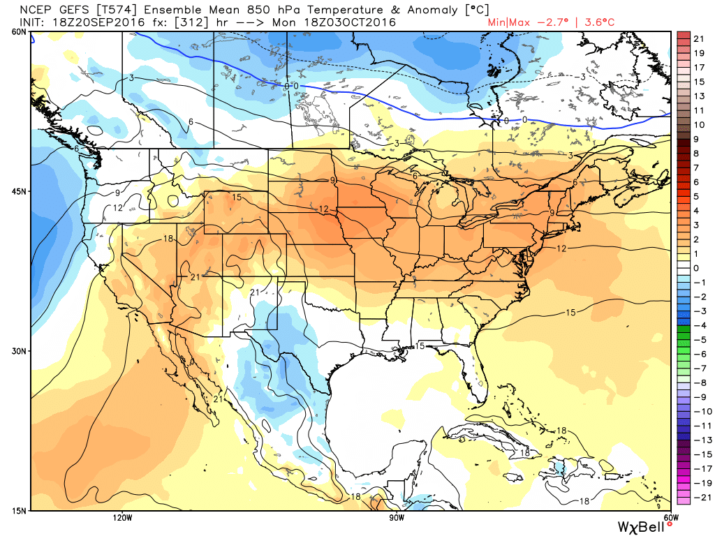
Longer-range guidance has warmth spreading across much of the country, particularly the east, as we begin October. Source: Weatherbell