Eye On Weather: Why Has It Been 25 Years Since The Last New England Hurricane?
BOSTON (CBS) - Many people are wondering why it has been so long since we've experienced a hurricane here in New England. Well, weather is very cyclical and that pertains to hurricanes as well.
Read: More 'Eye on Weather' Stories
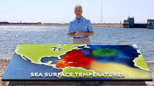
Hurricane eras switch between active and inactive periods that last 2-3 decades. These periods are caused by fluctuations in the sea surface temperatures across the ocean known as the Atlantic Multidecadal Oscillation (AMO). Check out this AMO Index chart depicting peaks and valleys.
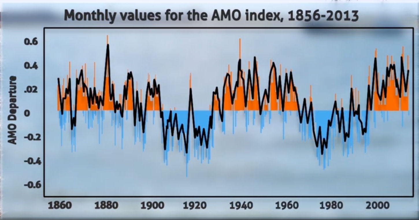
The peaks or positive departures in red indicate above average sea surface temperatures. The valleys or negative departures in blue indicate below average sea surface temperatures. Interestingly, the peaks closely match active hurricane periods and the valleys closely match inactive hurricane periods.
HURRICANE CYCLES
The late 19th century was very active. In fact, over any 10-year period on record, the greatest number of hurricanes making landfall in the U.S. occurred between 1879-1888. There were 27! After that, there was an inactive period for the first 25 years of the 20th century.
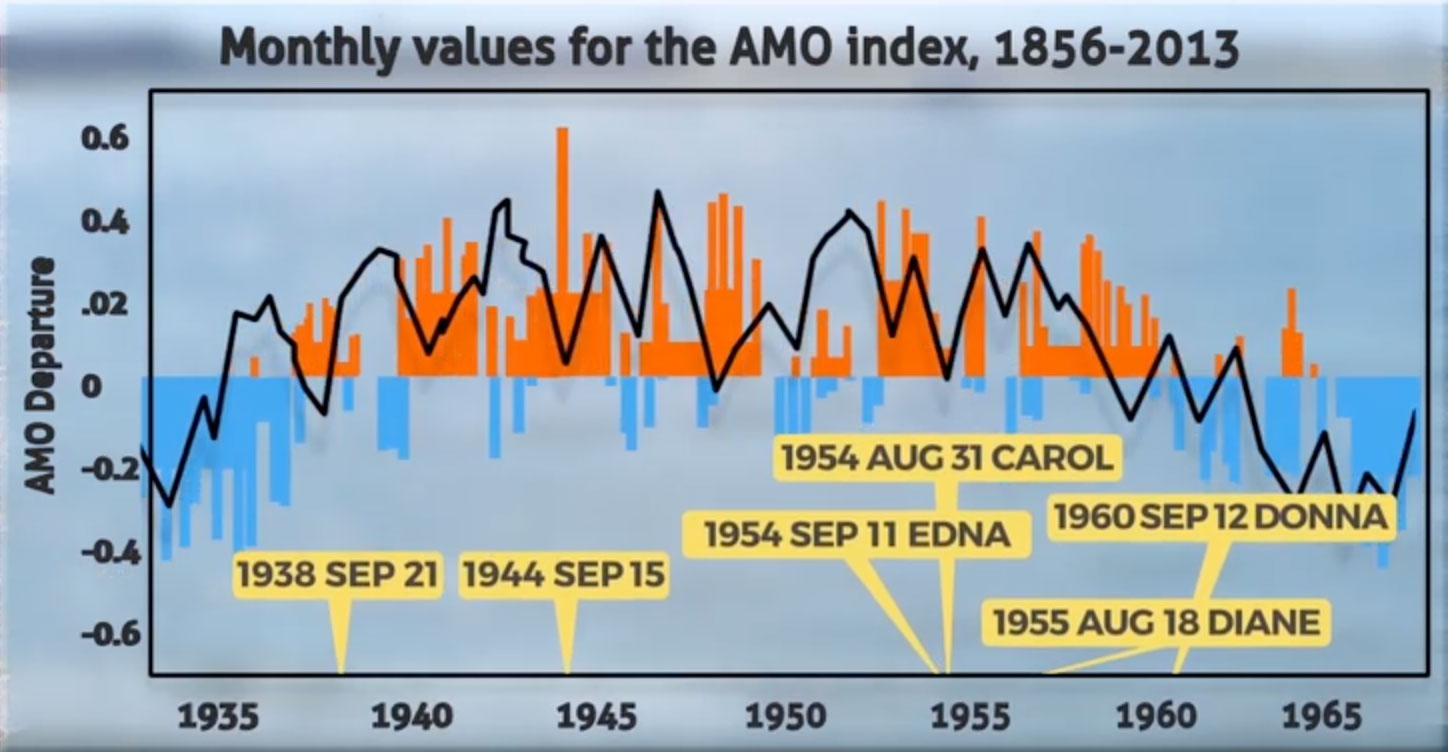
That was followed by a very active hurricane period from about 1935-1965 and New England got slammed.
1938 Sep 21: Most powerful, destructive and deadliest to strike New England in modern times
1944 Sep 15: Ranked a Category 3 hurricane with worse damage on Cape Cod than from the 1938 hurricane
1954 Aug 31: Carol a Category 3 hurricane producing significant damage and flooding
1954 Sep 11: Edna a second strike in 10 days, 100+mph winds southeastern Mass.
1955 Aug 18: Diane record fresh water flooding
1960 Sep 12: Donna sixth hurricane strike in southern New England in 22 years!
A sharp drop in hurricane activity occurred from the late 1960's to the early 1990's which coincides with the period of below average sea surface temperatures.
Enter 1995-2015 which has been a very active period of Atlantic hurricanes.
In 2004 and 2005 alone, there were 43 named tropical cyclones! 24 became hurricanes and 13 became major hurricanes, which means the sustained wind exceeded 111 mph! 7 of those 13 major hurricanes made landfall in the U.S. and one of those was Katrina smashing New Orleans, and Gulfport, Mississippi.
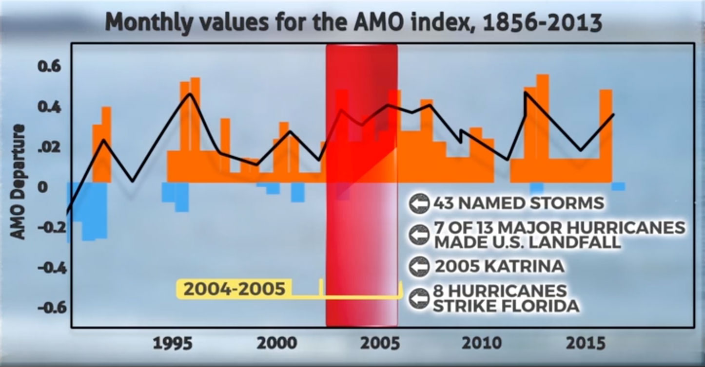
A record number of named storms (28), a record number of hurricanes (15) and a record number of major hurricanes (7) occurred in 2005 alone! Florida was hit by a whopping 8 hurricanes in 2004 and 2005 yet NONE have hit the Sunshine State over the past 10 years which is an amazing record within this active period! There have been 66 Atlantic hurricanes, 27 of which became major all at sea since the last landfall which was major, Hurricane Wilma crushing Florida in October 2005.
Shockingly, but thankfully, through this entire very active period of the past 20+ years, New England has remained unscathed from a direct hurricane hit!

In late August 2011, our area was impacted by Tropical Storm Irene featuring some serious flooding in western sections of the region. Plus outer bands of Sandy produced some rain and mostly minor wind damage here in late October 2012.
Most recently, there was a threat from weak offshore Tropical Storm Arthur which prompted moving 4th of July celebrations a day earlier and that is the only tropical action of note here.
THE DRIVER OF THE SEA SURFACE OCEAN TEMPERATURES
So what is the engine that controls the gyrations of the sea surface temperatures of the ocean, the Atlantic Multidecadal Oscillation(AMO)?
It all stems from the motion of the ocean- a giant conveyor belt called the thermohaline circulation which is an overturning current that transports warm water from the tropics and subtropics poleward near the surface and is converted into cold, dense water that sinks and flows back toward the equator. It is hypothesized that changes in the ocean salinity drive the strength and speed of the current of the thermohaline circulation. Greater salinity produces faster currents which in turn cause the ocean temperature to rise spurring more hurricane development.
HURRICANES AHEAD?
Where are we now and where are we headed in the years ahead regarding hurricane frequency?
The AMO has been in a positive or warmer than average phase for about 20 years. Noting that history reveals active and quiet periods of hurricanes last for 20-30 years, is the current active period almost over or could it linger up to 10 more years?
Over the past two years, colder than average sea surface temperatures have developed over the North Atlantic near and south of Greenland and the water in the tropical Atlantic has cooled a bit as well. In fact, the far North Atlantic component of the AMO was the coldest on record (since 1948) for April! These are signatures that the AMO is trending colder and may be approaching a negative phase. An expansion southward of below average sea surface temperatures will eventually materialize in a horse-shoe shape from the North Atlantic curving down over the eastern Atlantic westward into the tropical Atlantic with warmer water lingering off the U.S. East Coast. This predicted scenario would support a transition to a quiet period of hurricanes in the years ahead. With eventual cooling of the tropical Atlantic, more shear and higher air pressure will induce drier, sinking air, hence a more stable atmosphere squashing tropical cyclone development.
While it seems apparent that the state of the AMO is the primary driver of the active and quiet hurricane regimes, other global factors can influence any given hurricane season.
For example, last year's strengthening El Nino favored a period of robust hurricane activity in the Pacific. Meantime in the Atlantic, this phenomenon creates stronger winds aloft over the tropics which shear off the tops of potential storms. The overall so-called Accumulated Cyclone Energy (ACE) in the Atlantic dropped off last year despite having near average numbers of named storms. The decrease in total energy was caused by the El Nino which reduced the longevity and strength of tropical cyclones.
The real test to determine if we are indeed entering a quiet period of hurricanes will come this season.
As El Nino fades and blossoms into its reverse known as La Nina by the peak of the hurricane season, there is much less shear to rip apart developing storms. Consequently, if the amount of hurricane activity remains low in a more favorable environment for tropical cyclones, we may conclude the AMO is dominant and it is turning negative or cooler and unsupportive of hurricane activity. Stats reveal that the probability of a landfall Atlantic hurricane on the East Coast drops from 32% when the AMO is warmer than average down to 15% when the AMO is cooler than average.
While we are forecasting a trend toward a quiet period of Atlantic hurricanes lasting 20-30 years, we must remain vigilant because there can be short-term periods that defy the long-term regime. In other words, during quiet Hurricane periods, there can be brief blips of higher activity and vice versa.
And some of the deadliest hurricanes have occurred during inactive periods such as Category 4 Hurricane Hugo which devastated the Charleston, SC area in 1989 and Hurricane Andrew which destroyed southern FL in 1992 and Hurricane Bob which produced much damage and flooding in New England in 1991.
In conclusion, while hurricane cycles are very important, the pattern of the steering currents plays a crucial role in determining if these ocean beasts will be directed onto the coast or propelled out over the open ocean.
New England has been slammed during active periods of hurricanes (1935-1965) and been free of any hurricanes during other active periods (1995-2015).
On the other hand, while the probability of a landfall hurricane is much lower in an inactive period, it can happen then due to other global factors and the probability is highly a function of the overlying atmospheric weather pattern of currents that steer these storms.
Clearly, history dictates that a quiet period of hurricanes looms but as we have seen, a strike here cannot be ruled out. It's not a question of if but when the next one happens.
Roll the dice!
Interestingly, there has already been a hurricane this year. It was named Alex and it was the first hurricane to form in the Atlantic in January since 1938.
Coincidentally, that was the year of the Great New England Hurricane of 1938.


