December Blowtorch: All 50s and 60s Ahead
Find Eric Fisher on Twitter and Facebook
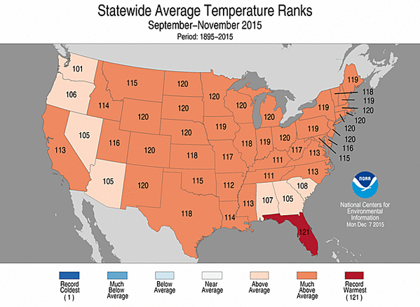
It was the warmest fall ever recorded in the Lower 48, without a single state seeing below average temperatures. More of the same has lingered into December. Source: NOAA
If you don't mind the moths, it's been one heck of a stretch here in southern New England. Granted the ski areas are probably not too excited, nor are those looking to set up their backyard ice rinks (or Winter Classic planners). But if you're just looking to be comfortable and stress free during the holiday season with no wintry weather to battle in your travels, this has been A+. No changes to that as we're full steam ahead in one of the warmest patterns you'll ever see in the month of December. Here's a look at what's expected, and how it stacks up to what we've seen in the past.
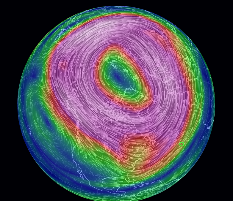
Current flow at 10mb (upper-levels of the atmosphere). Polar vortex is strong and generally undisturbed around the North Pole.
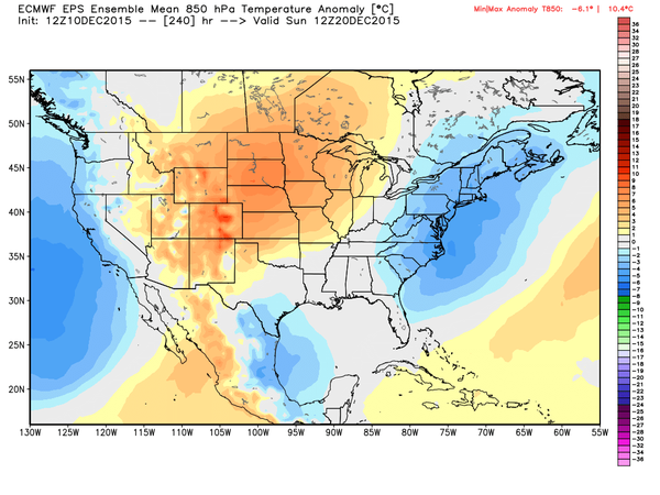
Let's start with the forecast. It's been a full on torch (weather geek slang for persistent, unusual warmth) to kick off December across the country. While El Nino is a player in this, you can also blame the polar vortex. Yes, THAT polar vortex. You hear about it all the time when your feet are frozen to the sidewalk so it's only fair to talk about it when you're jogging in shorts. There are many misconceptions about the polar vortex, and one is that a strong PV means you'll be freezing. In fact, it's the opposite. A weak PV allows big dips in the polar jet stream, with arctic air being unleashed from the frigid north. When it's strong, this upper-level circulation fences in all that cold around the high latitudes. Right now it's extremely strong, and therefore blasts of cold air have not made their way on down from America's loft.
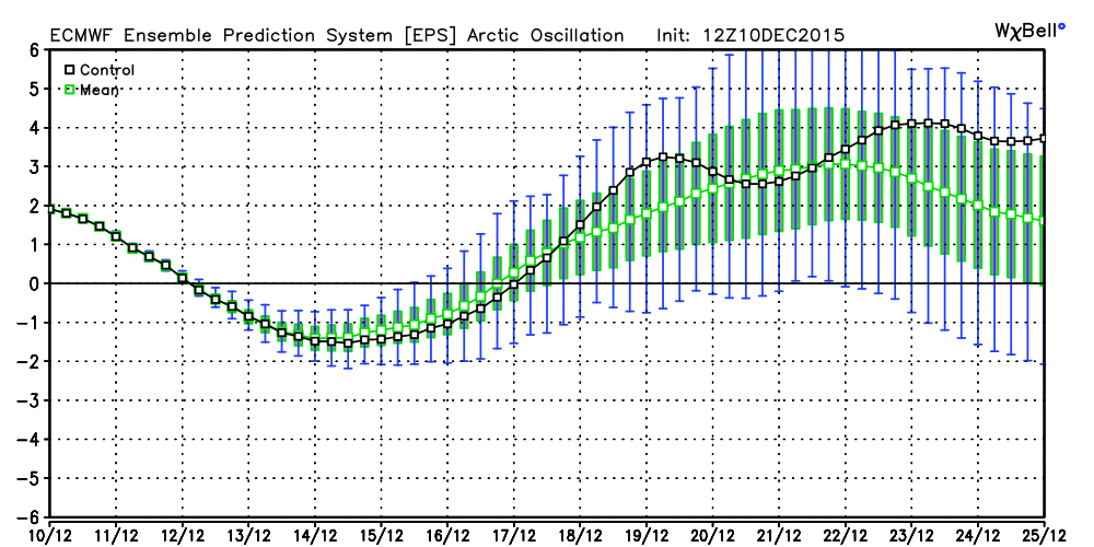
A quick dip in the Arctic Oscillation for the middle of next week, but then right back to a positive state. Source: Weatherbell
This is also shown by looking at the Arctic Oscillation. When positive, cold air intrusions are rare. When it goes negative, watch out. We had a heaping serving of -AO last winter. But it's expected to stay generally positive for the rest of this month. Ensembles (both the ECMWF EPS and GEFS) show milder than average air nearly every single day through the start of January. And so there's plenty of reason to believe we're going to finish up with a Top 10 all-time warmest December in the Boston area. That's after the 2nd warmest autumn ever recorded across the state. In fact, it's been so mild that the year will finish out warmer than average, even with the extremely harsh winter we endured to start 2015! Certainly a year on both ends of the spectrum.
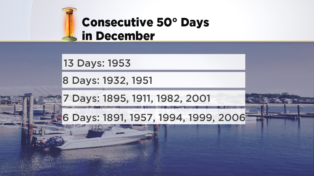
We should manage highs over 50F every single day from yesterday (Thursday) through the following Thursday. So that would make 8 straight if it verifies. Believe it or not, that's not even close to the record. In 1953, we rattled off a remarkable 13 straight days over 50 degrees in Boston! Even with that big league stretch, there have been several warmer Decembers than 1953. Our warmest on record was set just a few years back, in 2006. The Top 3 are rounded out by 1990 and 2001, followed by 1953 and then 2011. So three of the Top 5 have all been felt since the turn of the century.
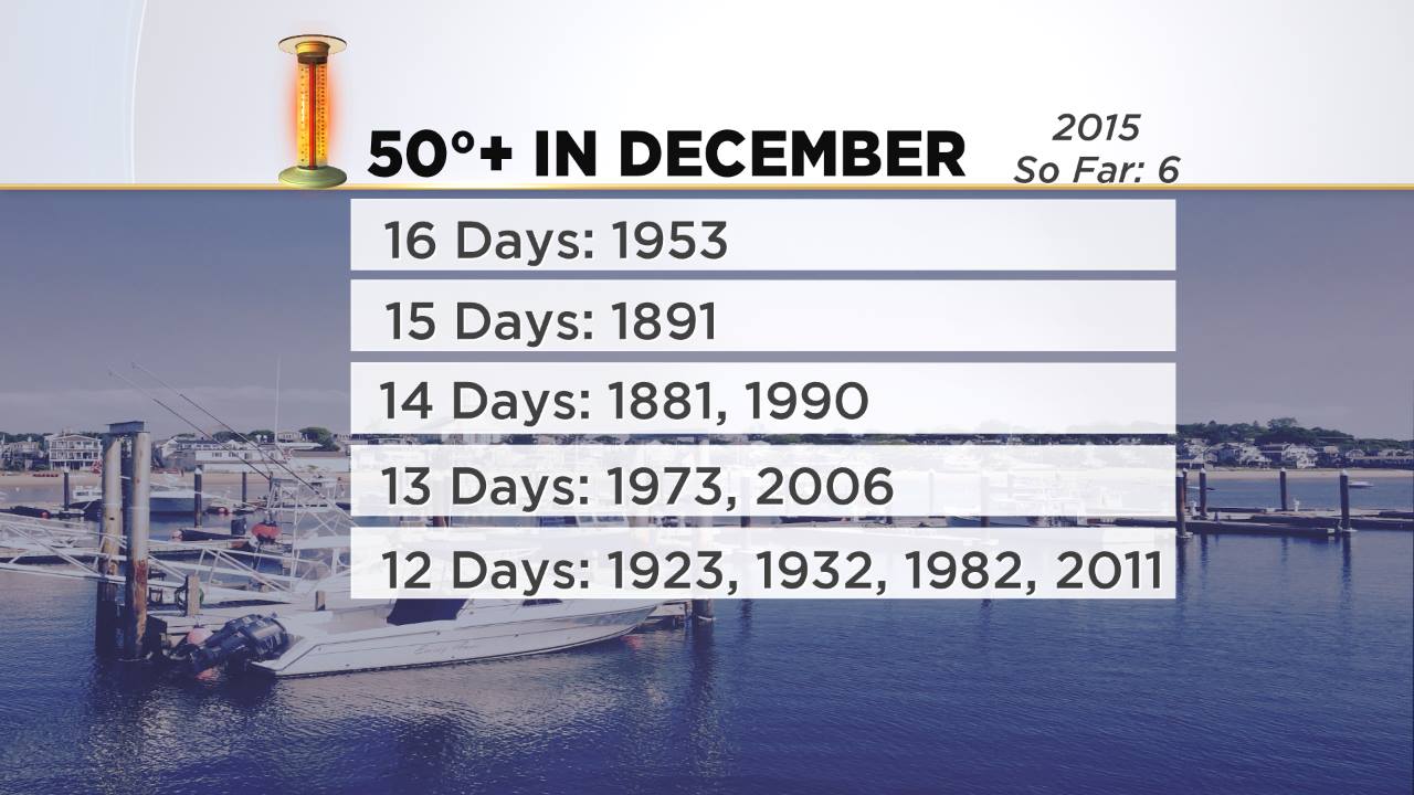
While I don't think we'll beat the record for most consecutive 50s, we may break the record for most total days in the 50s. So far we've had 6, and I'm thinking we will end up with about 16 of them for the entire month. That would tie 1953. I'd say getting to at least 12 is a slam dunk. With temperatures like these, expect to see some odd sights. There's a good shot we'll be featuring photos of cherry blossoms, forsythias, and lilacs on our newscasts over the next week. And yes, plenty more winter moths flocking to your backyard lights at night.
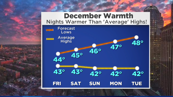
It's not just the daytime highs, but the overnight lows that are impressive during this run. Most of our lows will be higher than average daytime highs through the end of next week. Good news for landscapers and construction workers - the ground will stay unfrozen. That's definitely been a huge benefit of the pattern. Lots of work getting done later than usual into the season.
We may squeeze out a day or two of near or slightly below average temperatures around next weekend, before another warm-up moves back in. Source: Weatherbell
So will we see ANY cold air anytime soon? The way I see it, we've basically got one shot. There are signs we could at least return to average temperatures next weekend. There may also be a storm system around, which could *possibly* produce some flakes in interior parts of New England. But there are no harsh cold or big snow events in sight. Ensembles are even indicating another very mild Christmas like last year. But keep in mind that this was part of the forecast. December was expected to be mild, and then things were projected to turn chillier and snowier during the January/February time frame. So soak up the mild air while you can, because winter will show up eventually. It's just taking its time.
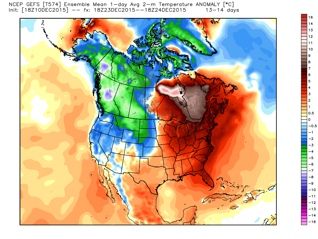
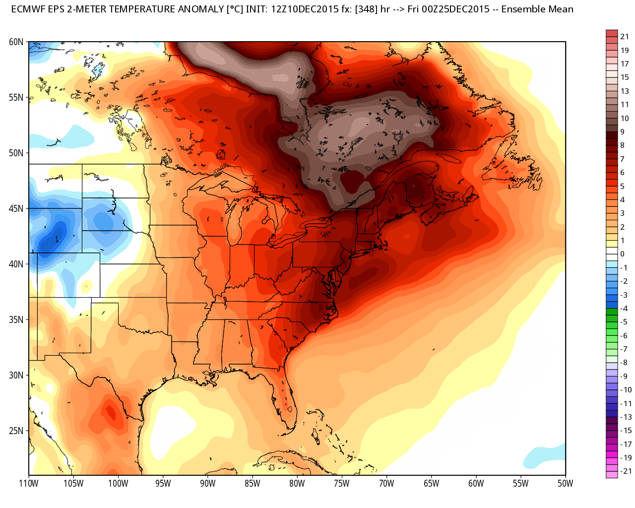
GFS and ECMWF ensemble systems showing more eastern warmth on Christmas Eve. Two weeks out is never a guarantee, but the signal has been very steady. Source: Weatherbell


