Goodbye October, Hello Winter?
This seems to be becoming an annual tradition around the Northeast.
Every late October-early November, a significant weather event starts to rear its ugly head in the computer models.
It was of course two years ago that Hurricane Sandy was making its approach into New Jersey. Shortly after that, a significant snowfall.
In 2011 it was 'Snowtober' bringing crippling snow and power outages to parts of the Northeast.
We got a little breather last year. I can't recall a major northeastern headline, but late October did include the St. Jude Storm bringing widespread flooding, power outages, 120 mph winds, and over a dozen deaths to Europe. And early November included the monstrous super-typhoon Haiyan striking the Philippines. Suffice to say, this is a time of year when the tropics are still active and the jet stream is starting to make its annual trip farther south into the mid-latitudes. So weather can start to get pretty wild.
This year, we're eyeing a *potential* storm system for this upcoming weekend. That being said, this one isn't even close to the lock that these other events listed above were. There's still a lot to iron out over the next few days, so I'll try to describe a 'heads up' version of what we do and do not know this far in advance. It's definitely something we'll be keeping an eye on all week and updating as we get closer. Always good to get some advance notice on these things just in case they come to fruition!
What We Know:
Temperatures
After a pleasant week, it's going to get cold. As in the coldest air of the season. This much seems to be a lock as models have been on it for over a week now and are showing no signs of backing off the cold plunge. If you like it chilly, nestled inside next to a fire, then this upcoming weekend is made for you.
A potent piece of upper-level energy will help drive this cold air mass into the Northeast. From where we sit now, it looks like we're in for highs only reaching the lower 40s for SE Mass, and very possibly staying in the 30s for the higher terrain and for NH/VT. This is close to, but probably not all the way, to record breaking territory if it pans out.
The record 'low max' (basically the coldest high temperature for the date) in Boston is 39º on Saturday, and 35º on Sunday. For Worcester, it's 39º on Saturday and 33º on Sunday. I think both of those are likely safe. For what it's worth, the record low in Worcester for Saturday is 16ºF! So it would take some pretty extreme cold to crack that nut. Not going to happen this time around.
Overnight lows are looking to be in the 20s for much of the area, especially Sunday night...so we may finally get a good region-wide killing freeze. This would be very late for a lot of spots which haven't hit 32º (see previous blog)
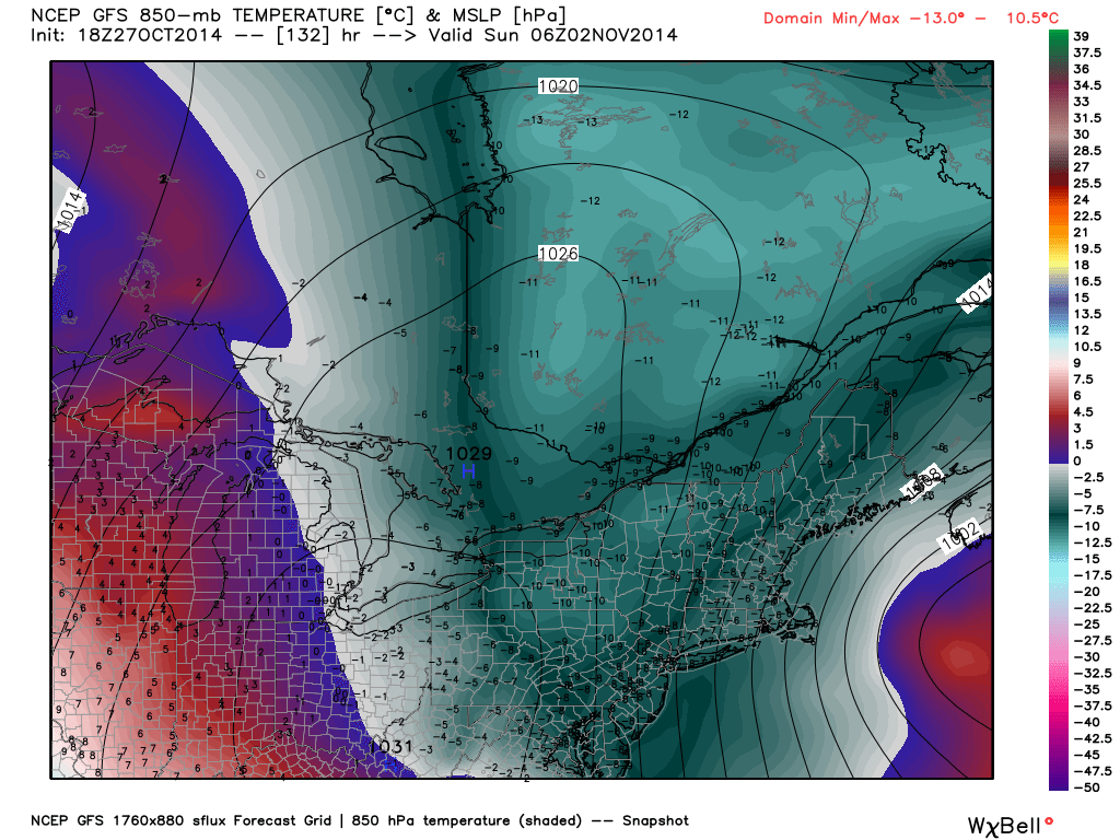
18z GFS 850mb temps. Won't be exact, but widespread -7º to -12ºC is colder than anything we've seen yet this season. Most higher elevations of New England won't leave the 30s all weekend, plus wind and nights in the 20s. Source: Weatherbell
Development
I have high confidence that a coastal storm will develop Saturday into Sunday. We're looking at a potent short-wave which may phase up with some southern stream energy and meet along the coast. At the moment, I think models are under-doing the strength of this future coastal low, and probably sending it a little too far east. Considering the impressive height anomalies involved, vigorous mid-level energy, and WAY above average sea surface temperatures off our Atlantic coast...I think it would be hard for a strong storm *not* to form. So we'll have that on our hands, the question is how close?
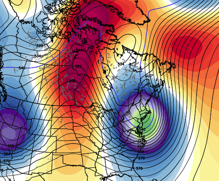
12z ECMWF EPS 500mb height anomalies. Shows a major trough setting up across New England. When the ECMWF ensembles are on board, it's time to start taking this potential as legitimate. Source: Weatherbell
Wind
Bringing down all that cold air will be plenty of wind. Some strong gusts look likely both Saturday and into the day on Sunday. This will add some extra bite to the air, and we may have to break out the 'wind chill' maps! At face value we could be talking in the 25-40mph range...but those details will be ironed out as we get closer. Bottom line is we're in for a cold and gusty weekend that will feel December-like.
Timing
All this comes together starting Friday night (fortunately, it appears after trick-or-treating time on Halloween). There are still some differences in exactly when the cold really kicks in. I'm thinking the coldest of the cold will be Saturday night through the Monday morning time frame. However, this cold shot does not look permanent. It's pretty progressive, meaning it will kick on out of here early next week. We won't be stuck with it for too long! Just a winter appetizer, if you will.
What We Don't Know
Location, location, location
Sure you could have the biggest storm in the world, but it doesn't matter if it heads on out to sea. There is still a WIDE spread in where exactly this low sets up, and plenty of chance that most of it will swing out to sea and leave us with just cold/windy weather. So this is really the main variable we're watching over the next few days. If it can get going just to our SE and then move into the Gulf of Maine, we'll have a significant event on our hands as the low occludes and throws moisture back into our cold air. If it doesn't get going until it's east of the Gulf of Maine, then fuggetaboutit.
The energy for this system is still up near Alaska with limited data coverage, so it's the usual winter story. When you're 5 days out, there is simply too much in the equation that can still change. The end solution will get more clear as we approach the weekend.
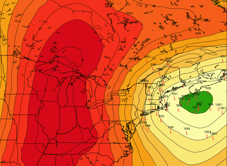
Great product from the ECMWF EPS - low locations. Basically it takes all the ensemble members of the ECMWF and puts all their projected low pressure centers on one map (I've only seen this product on weatherbell.com, which is a great site for weather). This illustrates the high uncertainty of where the storm will form at this time. You can see that all the members are spread out from on top of New England to way offshore with little impact. When they start to cluster around one location, that's when the certainty of the forecast goes up. I'd expect to see more of that in the next 24-48 hours. If high pressure swings in more from the west than the north, then the trend would be farther out to sea.
Exact Temperature Profile
Rain or snow? Even though it's the coldest air of the year, it's still borderline for a wintry event. Temperatures at the surface will likely be at or above freezing in a lot of spots. The depth of that above-freezing air has everything to do with what reaches the ground. As you might expect, the best chance for snow will be across higher elevations like the Worcester Hills, Monadnock region, etc. But it may get cold enough to crash the snow line all the way down to the coastal plain.
Not Just The Air, But The Ground
It's October, so we know the ground is far from frozen. It'll be plenty warm to melt a lot of the snow, unless this thing REALLY cranks up. But the impact on trees is not dependent on the ground temps. Cold air on Saturday could help cool their leafy surfaces, and it's those leaves that pose a problem with early-season snow events. It doesn't take much (say...a 3-4" wet snow event) to start bringing the limbs down. So it's something to consider if this really stays on target for us. We all remember 2011. Right now it's not looking like that, but it is in the group of 'potentials' and for that reason I'd encourage keeping up with the forecast on this one.
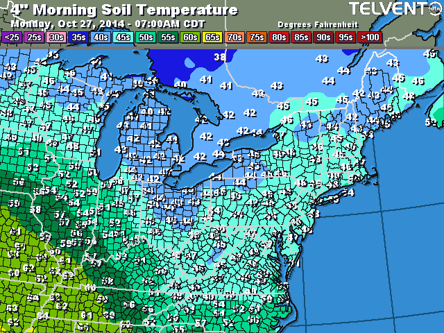
Current soil temperatures mainly in the 40s. Source: http://www.sfgiowa.com/weather?map=ne_soil_temps
Bottom Line
Basically, we're still in 'wait and see' mode. We know it's going to be cold. It's very likely that many towns will see their first flakes of the season regardless of a strong coastal storm. It's going to be a windy weekend for sure. And many will see a killing freeze. Outside of that, we'll be watching every single model run as new data comes in and updating the forecast as necessary. You won't be seeing any snow accumulation maps yet, because honestly the state of the science isn't there to accurately predict snowfall this far out. It's pretty hard even 24 hours out! So stay tuned as we obsessively check weather models and track the scenarios for this. My personal hope? First flakes of the season would be great, but I could do without a storm. There's nothing good that comes from snow with leaves on the trees. So we'll keep our fingers crossed for scenario #2.
Find Eric Fisher on Twitter and Facebook