Spring Temps for First Weekend of Winter
Find Eric Fisher on Twitter and Facebook
Who's ready for more daylight? I know I am...
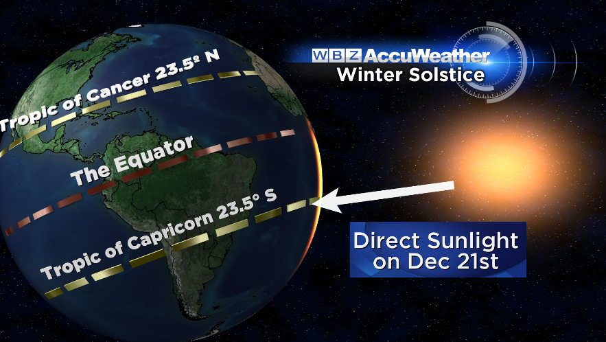
When does winter start? Well if you're a Meteorologist, it starts on December 1st (Meteorological Winter is December through February). If you go by the sun calendar, it's on the Solstice (which occurs at 12:11 pm EST Saturday). But if you're a realist, it starts when it gets cold and snows. So I'd say we've been in winter for a while. Be that as it may...the traditionalists say 'winter starts Saturday!' and as it does temperatures will rocket to spots well above average.
The setup this weekend is complex but we look to be on the lower-impact side of a major storm system causing all sorts of headaches across the U.S. Ice from Oklahoma to Chicago, and then onward to New York and New England will coat power lines and bring down limbs. Tornadoes and damaging winds are a big threat in the Lower Mississippi Valley. Up to 6" of rain may cause flash flooding in the Ohio Valley. But here? We bask in the 50s and watch our snow disappear.
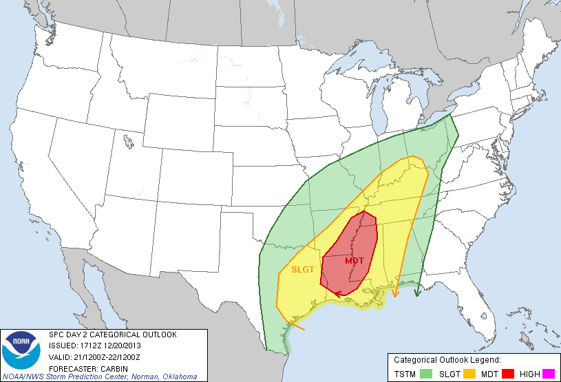
The SPC (Storm Prediction Center) has put out a 'Moderate Risk' for tornadoes and damaging wind gusts on Saturday
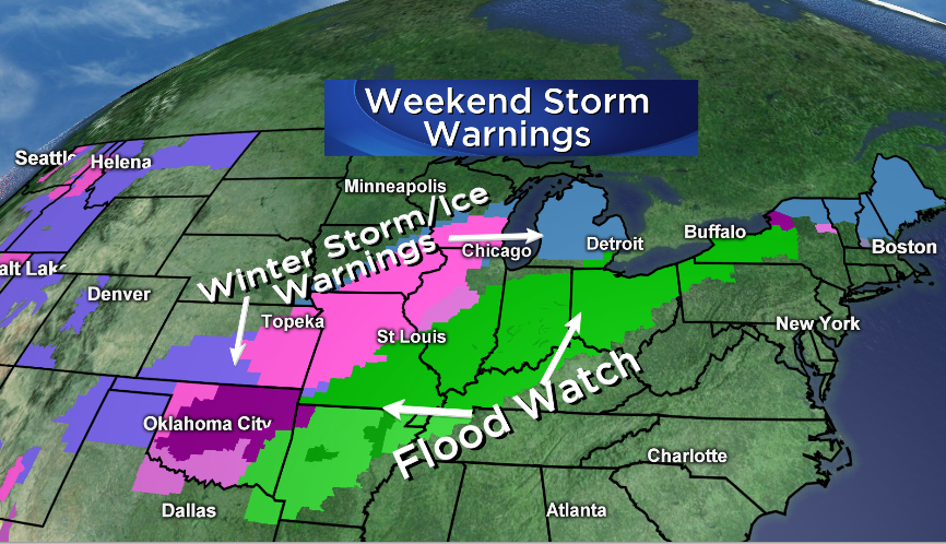
Plenty of mess to go around this weekend....National Weather Service offices keeping busy
What winter? A late-December thaw...
First off, let's talk temperatures. The quasi-stationary boundary cutting through New England will stay to the north of Massachusetts all weekend. That keeps us on the mild side, and for the majority of time the drier side. Friday night most towns will stay above freezing (the areas which may freeze back up are north-central MA and into southern NH). With increasing humidity, some areas of fog may develop overnight as well and mix in with a couple of light showers.
Saturday looks mild again, with widespread 40s and 50s. If we can manage some sun, we could even make the mid/upper 50s in a few towns. But either way there will be plenty of big puddles and very comfortable holiday shopping weather. No need to brave the cold to get that last-minute gift! The boundary we're keeping a wary eye on will try to dip south by Sunday, but I think all of MA avoids cold air nosing in. The only spot I'd be a bit worried about is northern Middlesex/Essex Counties. Everyone else should enjoy the 50s, and perhaps even reach toward 60. 850mb temperatures will near a whopping +14ºC, which is very unusual for this time of year. If it were summer and the sun was shining, that equates to highs in the upper 80s! With such warm air, poor drainage flooding could be an issue in spots due to all the melting snow.
Also keep in mind that lake & pond ice will weaken dramatically this weekend. What was nice and solid during our big cold snap will not be safe in most areas, so keep a close eye on kids and pets near the water. Ice hockey probably not a great idea.
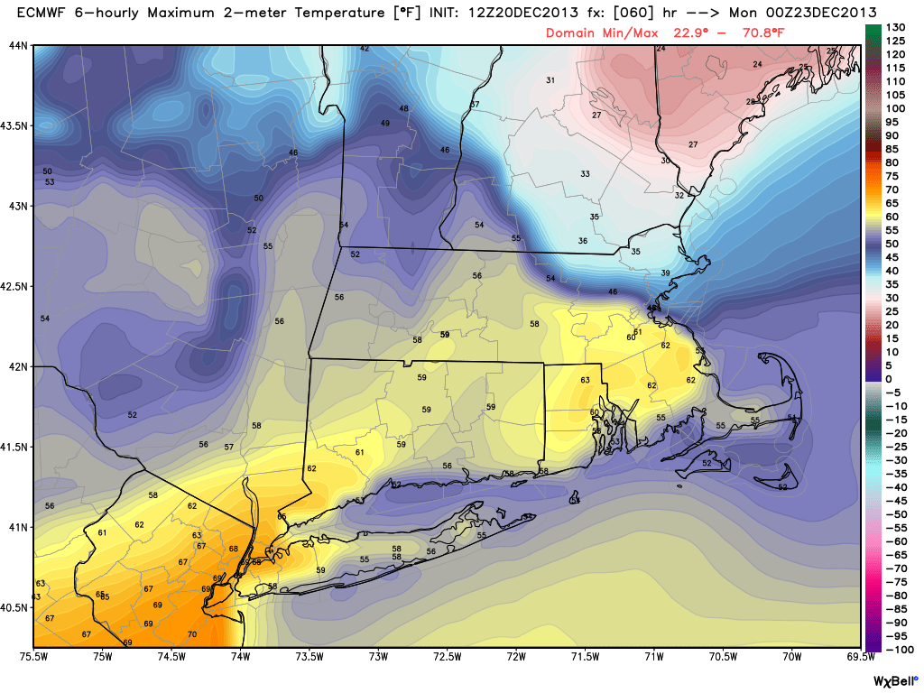
Wild temperature gradient forecast by the ECMWF - 30s to 60s within 50 miles! Courtesy: WeatherBell
Rain and Wind Potential...
Most of the wet and icy weather will avoid southern New England this weekend. There could be a few showers around on Saturday, especially for the Berkshires, northern MA, and southern VT/NH. The best shot of rain comes Saturday night as the boundary droops southward. Again, the best shot for any significant rain will be northern MA and southern VT/NH. Lesser totals are expected south of that line. Poor drainage flooding will again need to be watched and perhaps even some ice jams developing on a few rivers.
Sunday's rainfall will be scattered and tropical in nature. An unusually water-logged atmosphere for this time of year will provide the juice. It won't rain all day, but when showers strike it will likely come down hard. Also - with the odd weather situation and a bit temperature gradient, there will probably be some very gusty winds Saturday night into Sunday. Some of those gusts may reach or top 40mph on Sunday. So a mild, wild, and at times wet end to the weekend is expected.
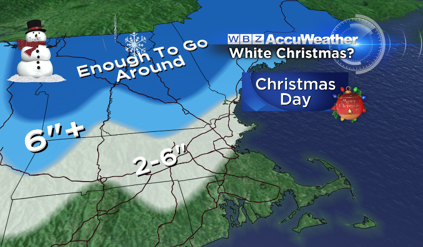
A White Christmas? Probably not from Boston to SE Mass.
Snow-eatin' Fog...
When you bring dew points in the 50s on a brisk southerly flow over snow, you get fog. And it should end up being as thick as peanut butter (courtesy: Yukon Cornelius) Saturday night into Sunday. So snow will continue to melt pretty quickly, even at night. Driving may become dangerous too with visibilities lowering to less than 1/4 mile.
The combo of warm temperatures and fog will do a number on the snow we have left. I've given a best estimate of how much may be left by Christmas morning. I'm thinking that south of the Pike you'll be hard pressed to find any snow outside of piles in parking lots by Wednesday (hills of RI and CT may hold onto some of theirs). There should still be some snow on the ground north of that line, but downtown Boston may be an exception as warmer air may do away with the vast majority of snow there. Around northern MA, I'll be surprised if all the snow is gone by the time Santa visits.
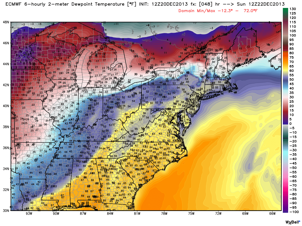
You could actually call it 'muggy' air moving in by Saturday night. Dew points reaching into the 50s, very efficient at eating away at snowfall. Courtesy: WeatherBell
Monday Travel....
The storm system responsible for all this mess will dangle a cold front near the coast through Monday, with a wave of low pressure riding up along it by Monday afternoon. This could bring a round of potentially heavy rain and more melting. We'll have to watch the threat of more poor drainage flooding and high water flow in local streams/rivers. Those showers may linger into early Tuesday morning before heading out to sea, and perhaps will end as a bit of snow with colder air rushing in.
Christmas Eve and Christmas Day...
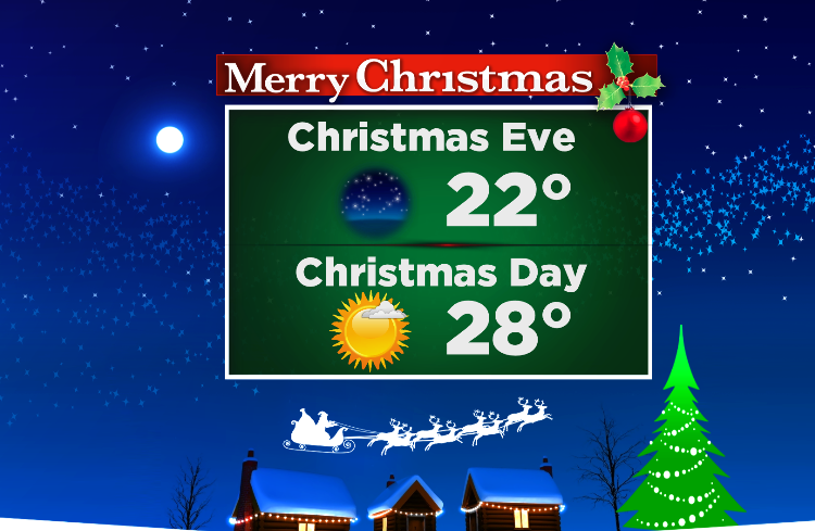
That pesky front should finally move completely offshore by midday Tuesday with Arctic air draining in behind it. Whatever we're at on Tuesday morning will be our high for the day, likely in the upper 20s to low 30s. A gusty wind will make it feel much colder, and it will be a downright cold Christmas Eve. Good weather for putting an extra log on the fireplace! Wind chill values may dip into the single digits by late evening.
High pressure crests overhead on Sunday, so lighter winds and plenty of sunshine for Christmas Day itself. Not travel issues anywhere nearby, and most of the country looks pretty peaceful. But will be quite cold - as of now it looks like most of our area will stay in the 20s.
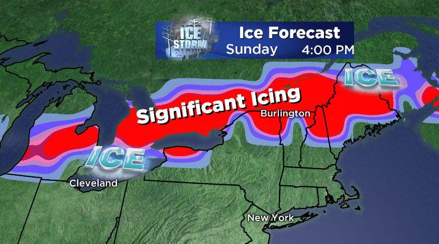
Major Ice Storm up North?
While all of this is happening, a major ice storm may be unfolding to our north. Anyone with friends, property, or plans in that direction should be prepared for what could be widespread tree damage and power outages. This mess has already started, with snow, sleet, and freezing rain falling since early Friday. That will be ongoing but light through Saturday. Travel won't be fun, but the damaging potential doesn't ramp up until late Saturday. A batch of moisture will move in from the west with the most potent of a series of low pressure waves, and this is where the most trouble is possible.
The issue at hand is that very, very mild air will be flowing up through the low & mid-levels. So in the clouds, it'll be rain that's falling. But at the surface, high pressure in Canada will direct cold air across the surface, keeping temperatures below freezing. So as the rain falls it supercools and freezes on contact.
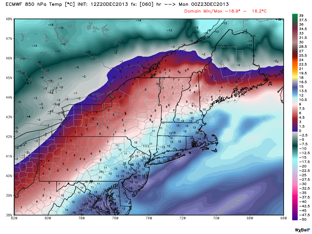
Note the surge of warm air at 850mb (few thousand feet up). With temps this warm, snow is impossible. Only spot for big snow this weekend is expected to be northern Maine. Courtesy: WeatherBell
Now forecasting a major freezing rain storm is very difficult, because the criteria is so strict. Conditions must be just right to see significant ice accumulation. We're talking temperature, topography, timing, etc. A little too much cold air near the surface and you've got a sleet storm. A little too much mild air works in and you change to rain. Some colder air funnels in a few thousand feet up and you change to snow. So the confidence is not enormous.
But over 1" of precipitation will fall, one way or the other. If much of that is freezing rain, it will be very destructive. 1/2" of ice accumulation adds 500lbs to power lines. Power crews have already put out mutual assistance calls and NSTAR has sent crews north to help with potential outages. The areas most at risk look to be around the Champlain Valley (Burlington area), northeastern NH, and much of central and coastal Maine. And the main timeframe to watch is Saturday afternoon through Sunday afternoon.
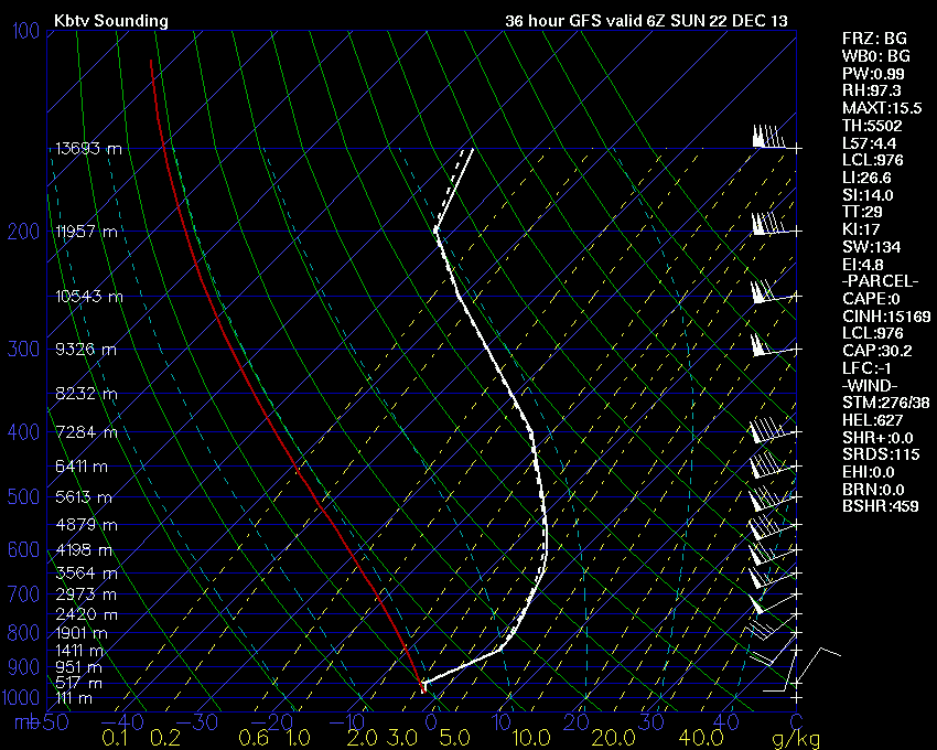
GFS model sounding in Burlington Saturday night. Note the subfreezing air at the surface, but above freezing air farther up in the atmosphere. Courtesy: Wright-Weather
Very specific elevation slices will be impacted. Valleys in amongst the mountains run the highest risk, because cold air can stay trapped by warmer air aloft. The higher mountain peaks will actually be much warmer and likely turn to rain. On Mt. Washington, they'll threaten record highs! Some of this icing may work as far south as southern NH/ME on Sunday.
So bottom line is to prepare for possible long-term power outages and to make sure you're ready to get through some tough days. If it doesn't pan out and we get more sleet or rain than anything else, than great. But it never hurts to get ready for the worst.