Change is in the air
It's almost over! We've been watching the slow march of a cold front passing through New England today, and by 11pm all the rain will be gone and the humidity will leave along with it. Once again, it was southeastern New England which took the brunt of the rainfall. Torrential downpours doused southeastern CT, RI, and SE Mass. Some towns again picked up anywhere from 1-3" of rain. One isolated swath on a line from the Falmouth to Sandwich area saw 2-4" of rain pouring down! That lead to flooded out streets and near impossible travel. But the official records at Boston Logan won't reveal the true story of the past 4 days, with only 0.76" of rain measured during this entire tropical stretch. Just goes to show the official record books don't always cover the events between the climate sites! Here's the total observed precipitation over our region for the past 7 days. You can easily tell where some of the bulls-eyes are.
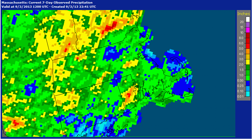 <---last 7 days
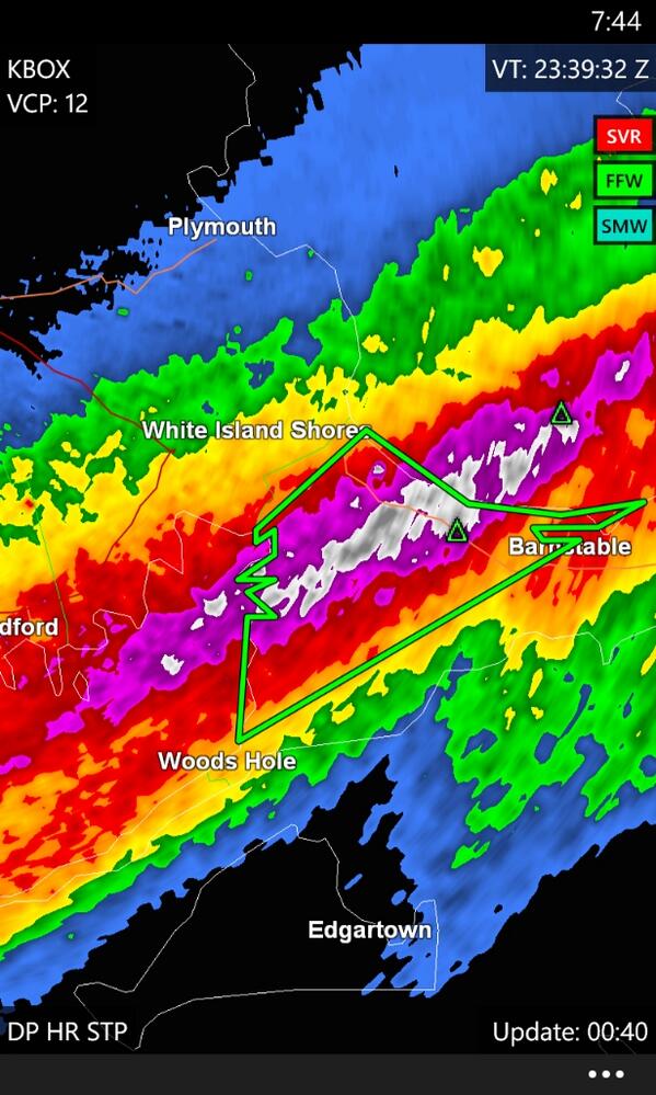 <--- The dousing tonight along the Upper Cape
Now for the good stuff. This front won't really bring colder air, but what it will bring is a wind shift and lower dew points. This evening our winds will turn WNW, and dew points will lower back into the 50s. While that's not bone dry air, it's definitely a marked change compared to the lower 70s of the past several days. With that drier air mass, tomorrow is looking excellent. A mix of sunshine with cumulus clouds and highs well up into the lower 80s (a good 5 degrees above average). The westerly wind will be fairly active, a consistent 5-15mph during the day. A good downslope wind to keep temperatures warm.
By Thursday, a backdoor cool front will drop down from the north. As of now, it appears it should arrive by the morning hours. This should bring some considerable cloudiness for a time and the chance for a couple of rain showers. Amounts should be nothing like what we just saw recently, with maybe 0.01-0.15" from anything that comes down. Temperatures will be noticeably cooler with the clouds and the winds shifting to a northerly direction. We may struggle to get much above 70.
That front will bring a blast of true autumn air. While I know many of you aren't in any hurry to get rid of summer anytime soon, those who love crisp fall weather will be loving Friday. There's even a chance that sheltered valleys of northern New England and the Adirondacks may see patch frost Friday morning! Around here, it looks like we should drop into the 40s. It will likely end up being the coldest morning since May 26th...a sign of the times. Most towns will end up staying in the 60s. But if you're not a huge fan of the chill, the cold air won't last for too long. Our winds will rapidly shift to the west on Saturday and bring a flood of milder air back into the region.
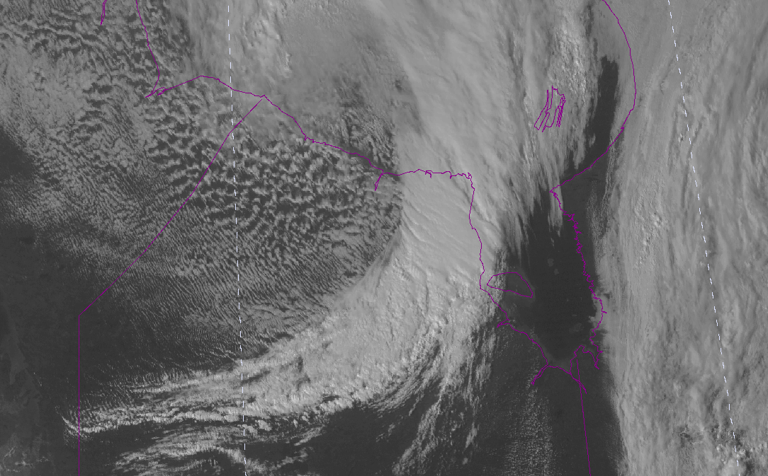 <--- Here's what we're watching. This comma-shaped system around Hudson Bay in Canada is the cold front that will blast through Thursday evening.
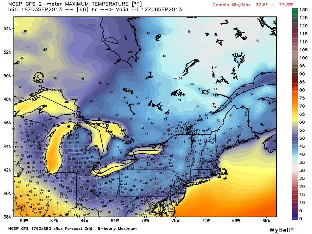 <---GFS prediction of Friday morning temperatures
The jet stream stays active looking toward next week. Another cold front will dive southward out of Canada on Sunday, bringing with it the chance of a few storms (I think it will have already passed Buffalo, NY by game-time Sunday, so hopefully will not interfere with the Patriots opener). A shot of cool air will follow it to kick off next week.
Status quo in the tropics. We're still watching Invest 97L and 98L. 97L is bringing disturbed weather to the Lesser Antilles, Puerto Rico, and the U.S. Virgin Islands currently, while 98L is just off the coast of Africa. No immediate development of either is likely. There are still a few models that want to turn 97L into a hurricane as it heads toward the Bahamas this weekend, but those solutions are outliers. For now, it will just bring downpours and gusty breezes along its path.
 Satellite loop of the Atlantic Basin. 97L is the system approaching the eastern Caribbean.


