Arctic Shot Coming To New England; Wind Chill Forecast In Single Digits Tuesday For Some Areas
BOSTON (CBS) -- I would say that, so far, this March has been fairly easy. We are averaging more than 4 degrees above average per day. Boston has only had 2.1" of snow, average to date is about 8". We have had some ups and downs but that is to be expected. Spring in New England isn't exactly supposed to be easy, but so far, so good.
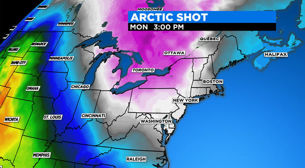
Does it feel like I am setting you up to drop the winter hammer? I wouldn't go that far, let's call it more of a rubber mallet. There is no snow in the forecast, no nor'easters and we all know it certainly isn't too late in the season for either of those. Instead, we are talking about cold.
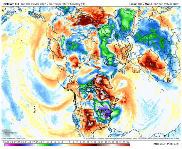
Take a look at this snapshot of the entire northern hemisphere early next week depicting temperature departures from average. Granted, it kinda looks like someone spilled a bunch of paint on a map if you are not used to looking at these charts, but, try to find the northeastern United States. Let me give you a hint, look for the darkest blues and purples. . . yep. Essentially what this means is that next Monday and Tuesday our area will be colder than anywhere else in the northern Hemisphere when compared to average temperatures. Fun!
So what does this mean exactly? Think a typical mid-January day, except it will be late March.
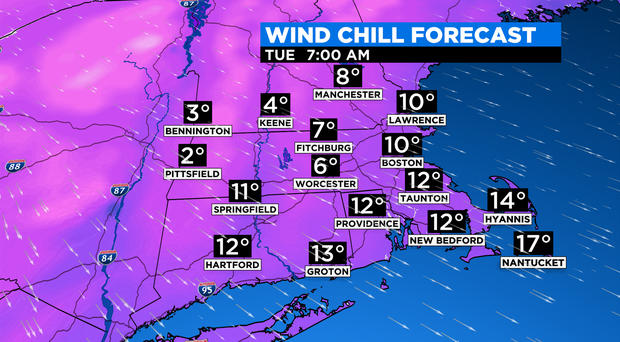
The core of the cold will crest over us on Monday. High temperatures "should be" around 50 degrees on average. Instead, most of southern New England will top out in the mid 30s. Tack on a gusty wind and the feels-like temperatures will be as low as the single digits Monday night into early Tuesday. Yuck.
The record low temperature in Boston on Monday is 11 degrees. . . on Tuesday it is 4. That ain't happening. We could challenge the record for the lowest, high temperature on Monday, that is 33 degrees set way back in 1893.
If Boston were to drop into the teens Monday night (unlikely but not impossible), that would be the latest Boston has done so since 1982. Perhaps some of you might even remember April of 1982, the first half of that month was one of the coldest and snowiest so late in the season in Boston.
Thankfully, most trees, bushes and flowers aren't too far along yet, otherwise this cold stretch could have caused major crop damage. Having said that, if you live in the Boston area or Cape Cod and have noticed some buds popping on your bushes, I would advise doing what you can to cover and protect them late Sunday through Tuesday.
Later next week, there are indications that we may get another substantial warm up. But, we have been fooled this time of year before. . . and next Friday does happen to be April Fools' Day!
Follow Terry on Twitter @TerryWBZ


