Freezing Rain And Sleet Makes Driving Hazardous Friday
BOSTON (CBS) - Ice is no fun.
I'd take snow any day over what occurred Friday morning. As the temperatures ticked downward and dipped below 32 degrees, the reports of accidents grew larger and larger. Roads that were once just wet, became treacherous within minutes. Sidewalks, driveways, steps, all untreated surfaces turned into skating rinks. If it hasn't happened at your house yet, it's coming.
The cold air doesn't just overspread the area in a straight line from north to south. When it first arrives, the cold layer is shallow (cold air is dense and sinks), so it literally seeps down mountains and hillsides and fills in the valleys first. The first few hours are always the most dangerous. It appears to still be plain rain but water is freezing on contact with the now cold surface (roads, driveways etc.). With the rain ongoing, it is impossible to pre-treat roads so, it becomes a race against time for crews to sand and salt the freshly formed ice.
As more and more cold air leaks into our region, eventually the layer of cold air becomes thicker and taller. Thus, the rain drops are falling in sub-freezing temperatures for a longer period of time. This causes ice pellets to form called sleet. And this is what we are seeing today. A brief period of dangerous freezing rain followed by a change to those pinging ice pellets. The sleet will accumulate a bit but will NOT accrete on surfaces like freezing rain.
As the cold air continues to fill in, the entire "column" of air will eventually be cold enough for snow. This may happen quickly enough (before the precipitation stops) north of Boston to produce some snow showers and scattered coatings Friday afternoon and evening.
WHAT'S NEXT?
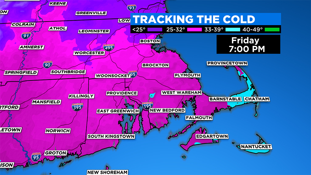
Just about all areas north of the Massachusetts Turnpike are below freezing as of noon and by 4 p.m. most of Norfolk, Bristol and Plymouth counties will drop below 32 degrees. Finally, last but not least, between 4 and 8 p.m. the Cape and Islands get their freeze.
The precipitation becomes more showery in nature between 4 and 8 p.m. and by 8 p.m. to midnight the few remaining showers are over extreme southeast Mass. with just some very light pockets of freezing drizzle elsewhere.
I would imagine that by the evening commute, most main roads will have some sort of ice treatment on them making travel a bit safer. Still, I would keep speeds down and certainly beware on the secondary roads, overpasses and typical colder spots.
Temperatures will continue to drop overnight into the teens for areas north and west of Boston, low 20s south and east.
We don't recover much at all on Saturday. Highs during the afternoon will be stuck in the low to mid 20s despite getting a good deal of sunshine. Not much change at all on Sunday, the entire region still stuck in the 20s, below freezing. Thanks to some sunshine, despite the cold temperatures, some of the exposed ice will melt a bit during the daylight hours this weekend, so you may be able to chip away a bit at the driveway.
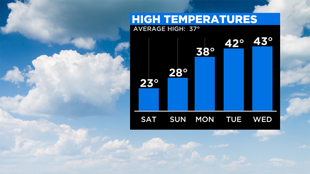
Finally, next week looks relatively quiet, just what the doctor ordered. Just a slight chance of a few rain showers brushing eastern Mass. Tuesday, otherwise temperatures will be mainly in the upper 30s and 40s.