Snow And Rain, 50-70 MPH Wind Gusts Arrive In Massachusetts During Powerful Monday Storm
BOSTON (CBS) — Winter is here and it's a messy start to the week for much of New England.
How do you follow up one of the coldest weekends in years? Naturally, with rain on Monday. That's just how we roll here in Boston. It isn't all rain though.
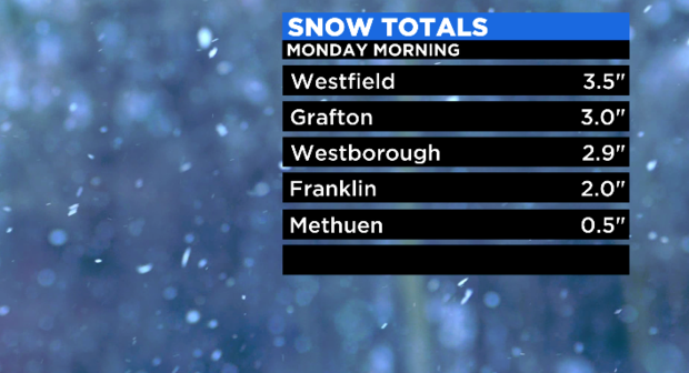
Before 6 a.m., interior locations measured 2-4 inches of wet, compact snow. This is leading to very slick travel on Monday morning.
Those in eastern Massachusetts shouldn't put their guard down. A slushy 0.5" was recorded in Methuen.
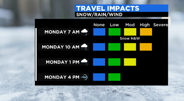
Steady rain will replace the flakes but pavement temperature will still cold enough to make for slippery spots. Bottom line, take your time on any drive early on.
POWERFUL STORM ARRIVES
Without any blocking present across northern latitudes, this storm is going to literally head right up the gut, west of our area.
Most of our classic snowstorms encounter some resistance up this way and end up passing just south of Nantucket, leaving us on the cold side. Not this time though.
While most of southern New England started Monday as a brief period of snow, for many, it won't last long. The precipitation arrived between midnight and 4 a.m. on Monday morning. It started as snow everywhere west of I-95, likely all rain east of that.
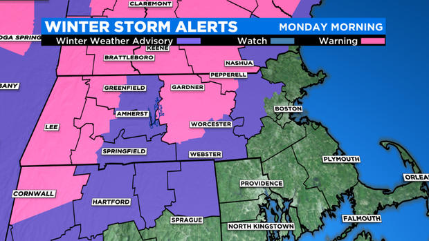
The heaviest rain and snow occur between 4 a.m. and noon Monday, and we expect any wintry precipitation will rapidly give up ground to all rain. You'll have to go way north and west into New England to still be dealing with much sleet or snow by the start of Monday morning. There are Winter Weather Advisories and Winter Storm Warnings in place outside for parts of our area.
The snow "jackpot" from Monday's storm will be out in the Berkshires to New York State and far northern New England where 8-12"+ will fall.
Snow totals diminish quickly to the east and south. Expect 2-4" before the change northwest of Worcester. North of Route 2 may be our local jackpot location, where 4″+ will fall.
Between 128 and 495, a quick coating to 2″ at most, likely all washed away by the change to rain. If you are traveling during the overnight hours, you could find some slick spots before the changeover.
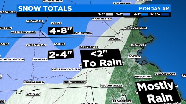
And again, all rain in Boston and along the immediate Coastline down through Cape Cod.
Quick snowfall note on this storm — if you wake up at 7 a.m., look outside and see meager snow totals, some (or all) may have melted away. The rain and mild temperatures will decimate the snowpack quickly.
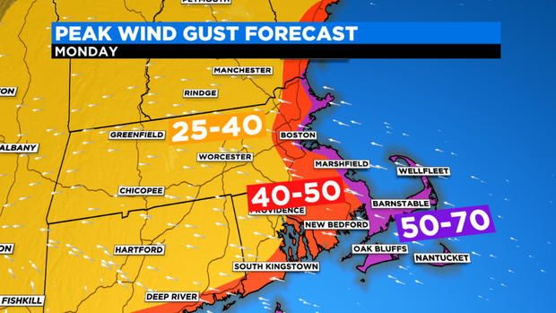
For eastern MA, the main concern will be the wind. We could see gusts out of the east-southeast between 50-70 MPH close to the coast and especially over Cape Cod and the Islands Monday morning. There could even be some embedded thunderstorms in the heavy rain area!
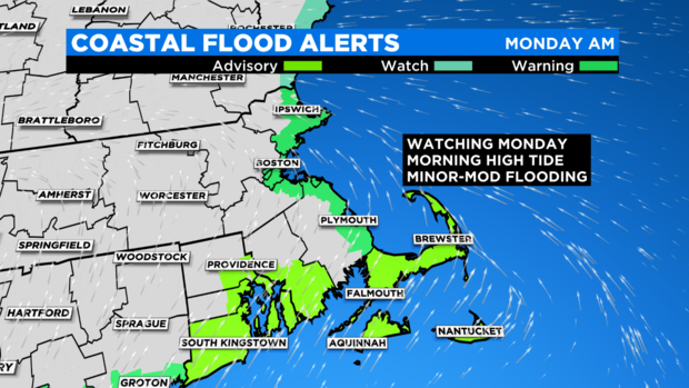
Lastly, there could be some minor to moderate coastal flooding during the Monday morning high tide (between 9 a.m.-noon.) Wind direction will be key. If the winds stay out of the southeast through high tide, we will see significant splash over along the eastern beaches. If the winds veer to the southwest a bit early (they are headed that way eventually), that could help push some water away from the coastline. Either way, something to watch for Monday mid to late morning.
This storm is another quick mover though. The rain/snow and wind will quickly taper around midday, and things will quiet down significantly in the afternoon.
No big storms likely in the days to follow, just more cold. Highs generally look near to slightly below average for most of next week. Next window for another storm appears to be around the following weekend.
Lots going on! Stay tuned for frequent updates on WBZ-TV, CBSBoston.com, and CBSN Boston.