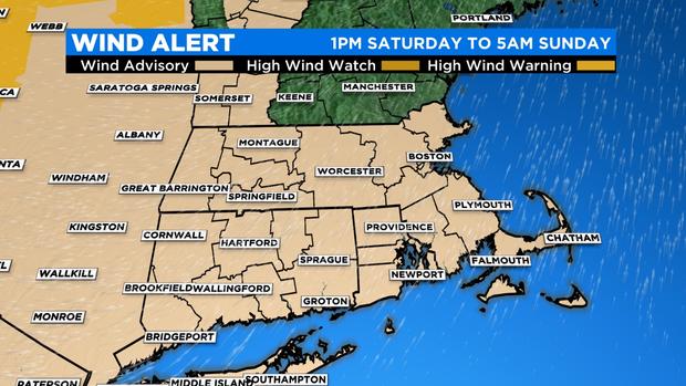
40+ MPH Winds Expected Across Southern New England Through Early Sunday Morning
BOSTON (CBS) -- A true battle of the seasons played out on Saturday.
The slow approach of a warm front meant cold air trapped close to the ground and had a hard time being dislodged by the warm air from that front. This cold air allowed for slick spots early Saturday north and west of Boston, with a brief period of light freezing rain and drizzle.
Spring-like warmth replaced that chill from hilltop to seashore once the warm front made its way beyond the MA/NH border. It took all day to happen!
The caliber of mild air that moved in was potent enough to send temperatures well into the 60s for highs in the Boston area, which were transported on stiff southerly winds. Parts of Southeastern Massachusetts and the Cape saw frequent gusts of 40 mph through much of Saturday afternoon and evening.
The last part of the variable and volatile weather to move through comes in the form of a fast-moving cold front that sweeps through Saturday night. Most of us will see a round of showers move through late this evening and overnight, with a select few even experiencing an isolated thunderstorm.
As the front sweeps across Southern New England, winds will pick up through the region. Areas like the South Coast, Cape Cod, and the Islands still stand the greatest chance of experiencing some of the stronger gusts, which will be up near 50 mph. The National Weather Service has issued a Wind Advisory, which covers all of Southern New England. Officially, those advisories remain in effect through just before sunrise on Sunday morning.
Expect the winds to start relaxing through the area later in the overnight and into the first couple of hours before sunrise.
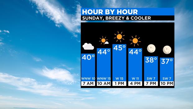
The cold front should then make its way offshore in time for some clearing and a much cooler, more seasonable Sunday, but it will be blustery.
Looking ahead to next week, temperatures should stay at-or-above average for the next 10 days or so. It's not great news for ski resorts, but could Santa come through with a pattern change by Christmas?
There are a few hints that things could get interesting. Stay tuned for more details!