December Weather Preview: Could Boston Have A White Christmas?
BOSTON (CBS) - Winter has arrived. Wednesday marks the start of December and meteorological winter (December-January-February). In case you missed it, the WBZ weather team put out a forecast for the coming winter a few weeks back and essentially called for more of the same…milder than average, less snow than average. But that is for the winter as a whole. What about December?
Let's start with the easy part, week 1…
Temperatures for the first week of December will likely end up below average. The average high for this period is between 45-46 and the average low between 32-33. Wednesday (Dec 1) will be close to average, Thursday (Dec 2) will be above average and then we get several below average days. Jury is still out on the track of a Monday (Dec 6) storm, but latest data suggest an inside runner and a milder solution. So, for now we will put Monday in the above average category. But, after that, it looks like another shot of cold.
So, average it all out and the first week of December should end up slightly colder than average.
We have some rain coming Thursday, a few sprinkles or flurries possible Saturday and the biggest threat, again, looking like rain, on Monday. Odds favor very little, if any, snowfall locally.

Week 2 is interesting…
It appears the atmosphere will be undergoing a transitional period during this timeframe. Longer range models are hinting at a possible flip from a fairly persistent trough in the East (and overall cold) to some ridging and warmth. Pattern changes are notoriously marked by storms. They don't always hit, they aren't always snow, but let's just say week two is a "period of interest". Looks like we will start colder than average for the first few days of week two before transitioning to a milder period by the end of week two. I would keep an eye on the middle of next week for some potential storminess before the milder air arrives later in the week.
Overall, temperatures in week two may end up close to "normal" with cold to start and warmth to finish but again, it may be a bumpy ride!
Week 3 looks mild…
It looks like the best chance for above average temperatures this December will be centered around the end of week 2 and into week 3, the week before Christmas. This is getting too far out in time to get into much detail, but I wouldn't bet on much snowfall happening in the east during this week. If temperatures overall for the month are slightly below average through the first two weeks, this week may get us back to average or perhaps move us above.
Could we have a White Christmas? Week 4 does look colder…
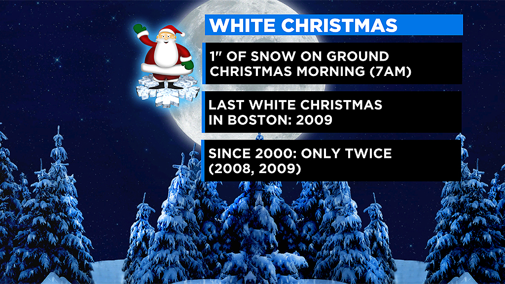
It is a ways out but most models favor the cold returning to the east for the end of December. Getting a White Christmas in Boston or the surrounding area is tough and requires a bit of luck. The "rules" tell us that to officially record a White Christmas, there must be at least 1" of snow on the ground at 7am Christmas morning. Given the fickle nature of December snow and our tendency in recent years for some very unusually mild days, this has become very difficult.
In fact, since the year 2000, Boston has only done it twice, in 2008 and 2009.
In 2020 the city got 12.7" of snow on December 16-17 only to have it wiped out by warmth and rain. Boston's high on Dec 24 was 53 and on Christmas Day the City hit 60 degrees with heavy rainfall.

In 2019 Boston recorded snow on 7 of the first 18 days of December, totaling nearly a foot. BUT, that was mixed in with several very mild days including 3 days of 60+. The days leading up to Christmas were also very mild, again wiping the slate clean of snow.
2018 was simply a very mild, snowless month (Boston recorded 0.1").
In 2017 Boston actually got 2.9" of snow on Christmas Day! BUT, it was after the 7am measurement…

I could go on and on, I think you get the point…snow in December is highly variable and doesn't always hang around long. Given the current forecast of milder times in the week before Christmas this year, I'd say we may be waiting and hoping for a miracle in the days leading up to the 25th.
To summarize, I see lots of temperature swings this December (what else is new)…whether or not the month finishes warmer or colder than average may come down to the last week (similar to November).
Snowfall-wise Boston averages 9.1" in December, Worcester 14.6"…I'd say odds favor finishing below those numbers, but of course it only takes one big storm!
Lastly, December is, of course, the month with the least amount of daylight. We bottom out on December 21st, the solstice, with just over 9 hours. But look on the bright side…the days will already be getting longer by month's end!