Heavy Rain Friday, Followed By Potential For First Snowflakes Of Season In Massachusetts Late Saturday
BOSTON (CBS) - It's the moment you've been waiting for - or dreading - the first appearance of that 4-letter winter word that sparks so many emotions.
SNOW.
What? Did you really think the weather was just going to stay sunny and mild forever? This November sure has been lovely. This is the first time we have started November with 11 straight dry days since 1976! After the record rainfall this summer and early fall, I can't imagine anyone is complaining.
But, alas, all good things much come to an end. And, in typical fashion, we do it with a bang here in New England.
First up, Friday's rain.
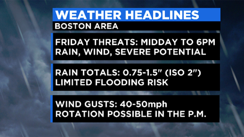
Massachusetts is looking at a 3-to-6 hour window of heavy rain, gusty wind, and even some embedded thunderstorms this afternoon.
Approximate heavy rain windows:
Worcester: 11 a.m. to 5 p.m.
Boston: Noon to 6 p.m.
Cape and Southeast coast: 3 to 8 p.m.
During the heaviest rain, there will be some south-southeasterly winds gusting 20-to-40 mph, particularly across southeastern Massachusetts. A Wind Advisory is up through 7 p.m. for all coastal areas where peak gusts could reach 50 mph.
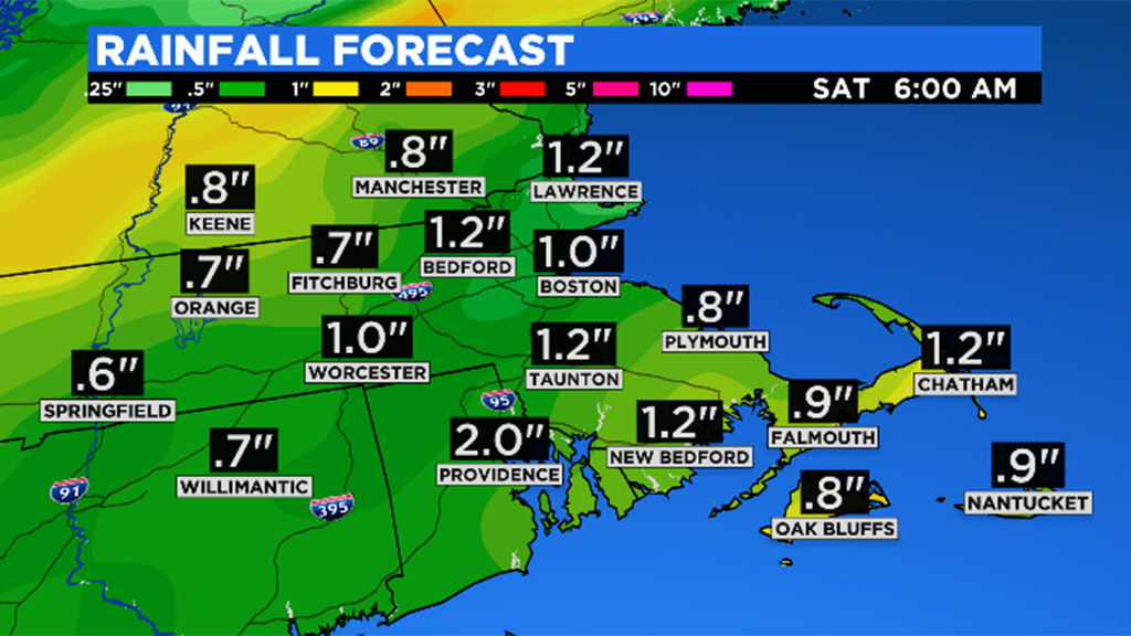
Total rainfall should be around an inch for most, perhaps up to two inches in isolated areas. Not enough for any widespread flooding, but some brief urban and street flooding is likely during the downpours Friday afternoon and evening.
Next up, our first flakes of snow.
Saturday is a pleasant day with highs near 60 with abundant sunshine. Clouds quickly return late in the afternoon and a fast moving area of low pressure brings another round of precipitation Saturday night. This round will start as rain when it arrives between 7 and 9 p.m. Saturday.
However, temperatures will not only be cooling due to darkness but also from above. The air above ground level Saturday night will be below freezing while the air at the surface will be in upper 30s to low 40s. The precipitation will draw some of that colder air down, perhaps just enough to change the rain to snow in parts of our area.
This is a very fast moving system, lasting only 3-to-6 hours, out of here shortly after midnight. And, temperatures closer to the coastline will likely stay a bit too warm for snow. Bottom line, to see the first flakes, you will have to be in the right place at the right time.

The best chance of seeing snow Saturday night would be in the higher elevations of central and western Massachusetts, the Berkshires and Worcester Hills. The snow may even briefly whiten the ground in parts of northern Worcester County.
Farther east, towards Route 495, we are talking about some snow mixing in with the rain. You would have to be outside or driving at the time to notice it, certainly no evidence left Sunday morning.
If you miss the snow Saturday night, there are a few more chances of scattered flurries Monday and Tuesday. No organized storms but just a general unsettled pattern which could produce a sprinkle or snow shower here and there.
If this feels early for snow, it really isn't. While the first average measurable snow in Boston is November 29, we do quite frequently see flakes in the air by mid-November. Don't forget, last year Boston had 4.3 inches of snow on October 30! Worcester's first measurable snowfall averages out around November 18th, nearly right on schedule.
If this little "taste" of snow isn't enough for you, tune in next week!
Each day at 5 p.m. on WBZ-TV our weather team will feature different stories looking ahead to this winter, culminating in our annual winter weather forecast with the whole WBZ team on Friday, November 19!
Follow Terry on Twitter @TerryWBZ