Saturday Evening Storm Brings 'First Flakes Alert' For Much Of Massachusetts
BOSTON (CBS) — After a busy Friday with flooding rain and strong wind, we're back to a storm threat for Saturday afternoon. Soak in any sun you can because it's going to be busy a bit later.
Another cold front will swing through between 4-7 p.m.
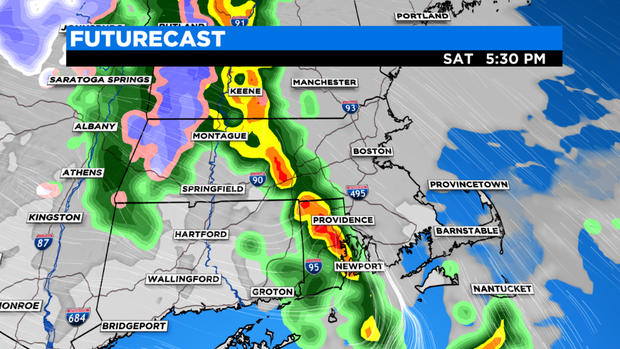
Fortunately, this is a quick-moving system, but that doesn't mean we will escape all the impacts. Any storms that develop will tap into some really cold air in the upper atmosphere, making small-to-moderate sized hail a likelihood. Although not to the same extent as yesterday, rain will come down in buckets. Totals will reach a half-inch to inch in many spots. The biggest concern is wind -- both straight line and the low (but non-zero) threat for a tornado. Most of the threat for wind damage is south of the Mass Pike, but isolated storms may contain wind up to 60 mph.
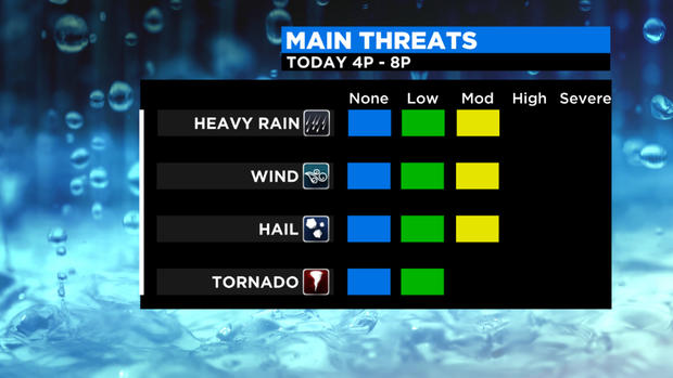
The Storm Prediction Center has 'upgraded' parts of southern New England to a slight risk -- level 2 of 5 on the impact scale.
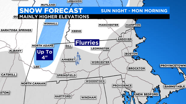
There could also be some wet snowflakes mixed in, particularly in the Berkshires and Green/White Mountains. Chances of accumulating snow are quite low, but there is a risk of a quick coating in the Mountains and as far south as the Monadnock Region. This is more of a "first flakes alert" for those eager to see some white stuff before the real stuff arrives (no timetable on that just yet).
Sunday night/early Monday:
A much weaker disturbance moves through early Monday morning. This may come through completely dry for many areas with just some isolated to scattered rain and snow showers. Once again, the best chance of seeing flakes would be well to the north and west of Boston, mainly in the elevated areas.
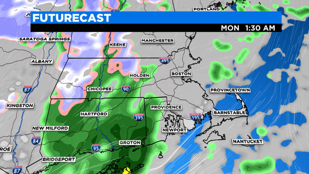
There may be some very light accumulations along Rt. 2 in northern Worcester County, but mostly just conversational flurries that melt upon hitting the ground.
Monday night/early Tuesday:
One final shot at an isolated flurry…this disturbance is hardly detectable on models, but enough to warrant a mention. Again, certainly, nothing to be concerned with here, just one final shot at seeing first flakes, most of which would be after dark Monday.
Sorry snow lovers, that'll have to do for now. If you are craving winter and snow, I would suggest tuning in to WBZ all next week! Each day at 5pm our weather team looks ahead to the upcoming winter, culminating with our official WBZ winter forecast on Friday.