Henri's Remnants To Bring One Last Round Of Heavy Rain To Massachusetts Monday
BOSTON (CBS) - Henri made landfall near Westerly, Rhode Island Sunday afternoon at approximately 12:15 p.m. Unbelievably, this is just about the exact same location where Tropical Storm Elsa made landfall earlier this summer. Before this year, we hadn't had a landfalling tropical storm in 15 years (Beryl in 2006 on Nantucket). Let's hope that will be the last of the landfalls this year.

Winds topped out at 78 miles per hour at Point Judith, Rhode Island and 68 mph in Newport and Block Island. Peak gusts in Massachusetts included 55 mph in Falmouth, 54 mph in Westport and several other between 45-to-55 mph.
Photos: Tropical Storm Henri Hits New England
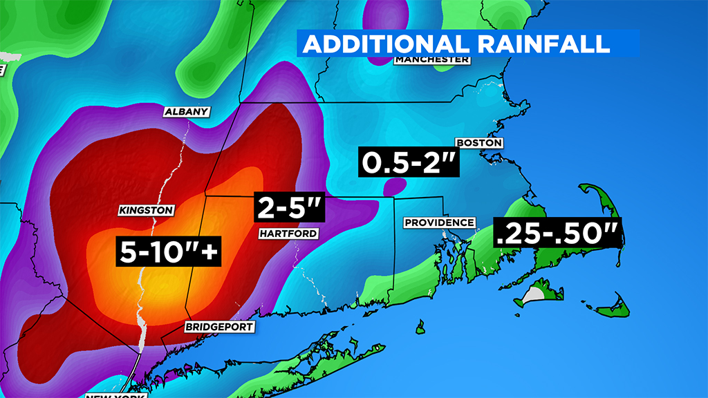
The heaviest rainfall from here on out will occur in western New England and eastern New York, to the left side of Henri's track. Parts of that area will receive 5-to-10 inches of rain when all is said and done.
In fact, with some upsloping in the elevations in New York State, its not out of the question that localized rainfall totals could top a foot! Needless to say, there are going to be some major flooding problems in eastern New York. Western Connecticut and western Massachusetts should escape the worst of the heavy rain and flooding, but this needs to be closely monitored (dependent upon how far west the center of Henri moves inland).
We aren't completely out of the woods in central and eastern Massachusetts as the remnants of Henri will get swept up by a front Monday afternoon and evening bringing one last round of downpours through the area.
Worcester County could see downpours arrive mid-to-late afternoon. In eastern Massachusetts, it will take a bit longer. The window of opportunity for downpours will be closer to 6 p.m. to midnight. We cannot rule out a severe storm or two, perhaps even a spin-up tornado. As seen with the remnants of Fred last week, this is always a concern with a tropical system or its remnants moving through.
We finally rid ourselves of Henri on Tuesday but we will be left with a very tropical-like airmass. Temperatures will reach near 90 degrees Tuesday, Wednesday and Thursday with oppressive humidity to boot. It's just another typical summer week in Boston 2021.
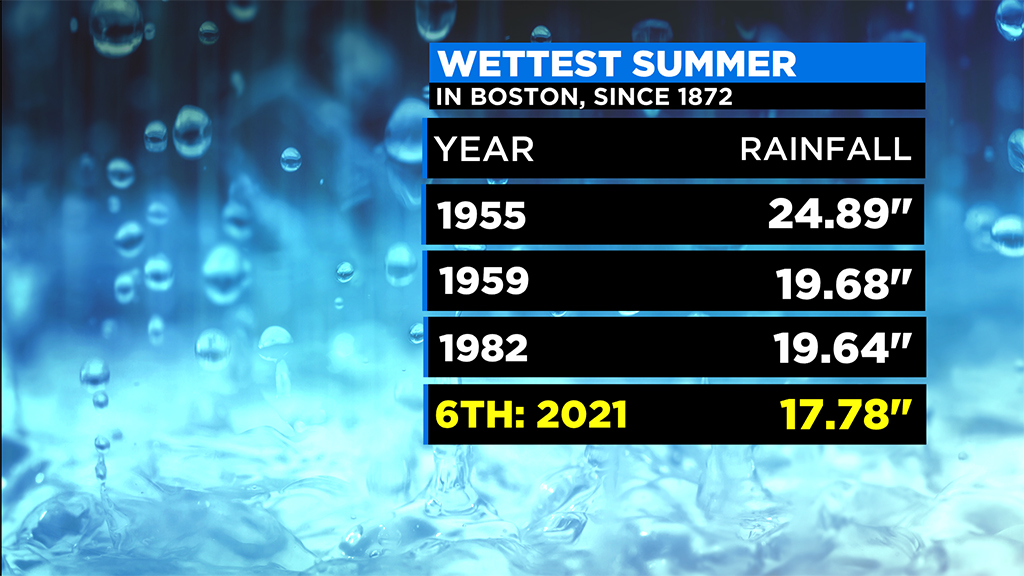
Currently, Boston is sitting at the sixth wettest summer on record (17.78 inches) with a real shot at getting as high as number two on that list (just a few more inches).
If it hasn't been the rain, the weather story has been the heat. This is also currently the warmest summer on record in Boston! The average temperature of 74.5 degrees is 0.4 degrees warmer than the summers of 1983 and 1949 (tied for number two on the list). Probably not an ideal summer for just about anyone interested in outdoor activities.
Again, here's hoping that we have seen the last of the tropical activity in New England this year. We still haven't had a landfalling hurricane here since Bob in 1991, let's keep it that way.
Follow Terry on Twitter @TerryWBZ