'Winter Is Going Out Swinging': Widespread 2-4 Inches Of Snow For Southern New England Expected Friday Morning
BOSTON (CBS) -- Winter is going out swinging. With the official start of spring just days away (Saturday at 5:37 a.m.), winter is clearly on the ropes, about to go down for the count. But, in typical New England fashion, it appears we are going to get one final punch to the gut before we can officially turn the page to spring.
This winter overall has been fairly dull. Just about our entire season's snowfall has come in five days (Oct. 30, Dec. 17, Jan. 26, Feb. 7, Feb. 19). These five "storms of note" were mainly quick hitters, and only one (Dec. 17) left more than 6" in Boston. And now, it appears we may add one final date, March 19 to that list.
Getting snow to accumulate this late in the season isn't easy. Most times you need the snow to come under cover of darkness, with a fairly high intensity and into an unusually cold airmass. It appears, we may meet those exact criteria for about a 6 hour window early on Friday.
TIMELINE:
Thursday, Noon-7 p.m.: Light rain arrives from the west, becomes steady, light to moderate by sunset.
Thursday 7 p.m.-Midnight: Temperatures drop and the rain changes to snow from northwest to southeast. Berkshires first to change between 7-9 p.m. Most of central and western MA change to snow between 8-10 p.m Eastern MA, north of Plymouth, changes to snow between 10 p.m.-midnight.
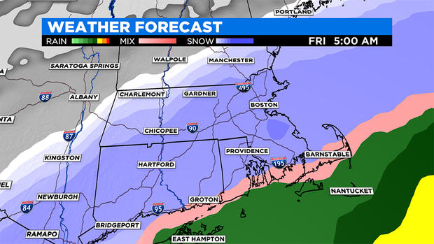
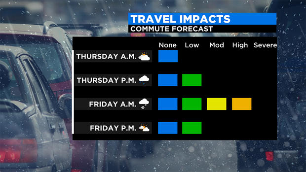
Friday 12 a.m.-7 a.m.: The colder air continues to slowly push southward, bringing snow and a mix all the way to the South Coast by about 5 a.m. This is the timeframe of greatest concern and when just about all of the snow accumulation will happen in southern New England. Snowfall intensity up to an inch per hour at times is likely.
Friday after 7 a.m.: The storm makes a quick exit out to sea and the snow tapers off by mid-morning. Very little additional accumulation expected after 7 a.m.
SNOW AMOUNTS:
Widespread 2-4" for most of southern New England north of a Plymouth to Providence line.
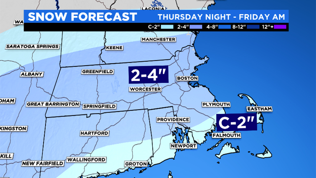
Coating to 2" south of Plymouth and Providence.
WIND:
North-northeast wind gusts will peak between 40-50mph over coastal Plymouth county, Cape Cod and the Islands between about midnight and 10 a.m. Friday. Elsewhere, winds will peak with gusts between 20-40 mph, highest closest to the shoreline.
HELLO SPRING!
With temperatures topping 50 this weekend and perhaps 60 at times next week, the snow won't be sticking around long. In fact, I would guess most will have vanished by the end of the weekend. Thereafter, there is no additional snow in sight and overall temperatures look fairly mild for a while. That always comes with a caveat here in New England this time of year though. Thanks to our position on the map and proximity to a very cold ccean this time of year, we will certainly be susceptible to the classic "back-door cold fronts" and daily seabreezes which always make forecasting and living here so much fun in March and April.
Follow Terry on Twitter @TerryWBZ


