Winter's Not Over Yet; Snow Expected Friday In Boston Area
BOSTON (CBS) - As we pass the midway point of March, we can finally start to ask the question, "is winter over?"
The calendar would tell us that winter will end this Saturday at 5:37 a.m. with the arrival of the vernal equinox.
If you mark the end of winter with our final snowfall, history would tell us that we need to wait a bit longer. The average final snowfall in Boston comes around March 29, however 5 of the last 7 Aprils in Boston have had some accumulating snowfall. And then of course there was that freak snow last May 9 - only a trace in Boston but nearly an inch in Worcester!
Clearly it ain't over 'till it's over in New England. And I am here to tell you, it ain't quite over.
It appears winter has plans to sneak in one final snowfall before the closing bell.
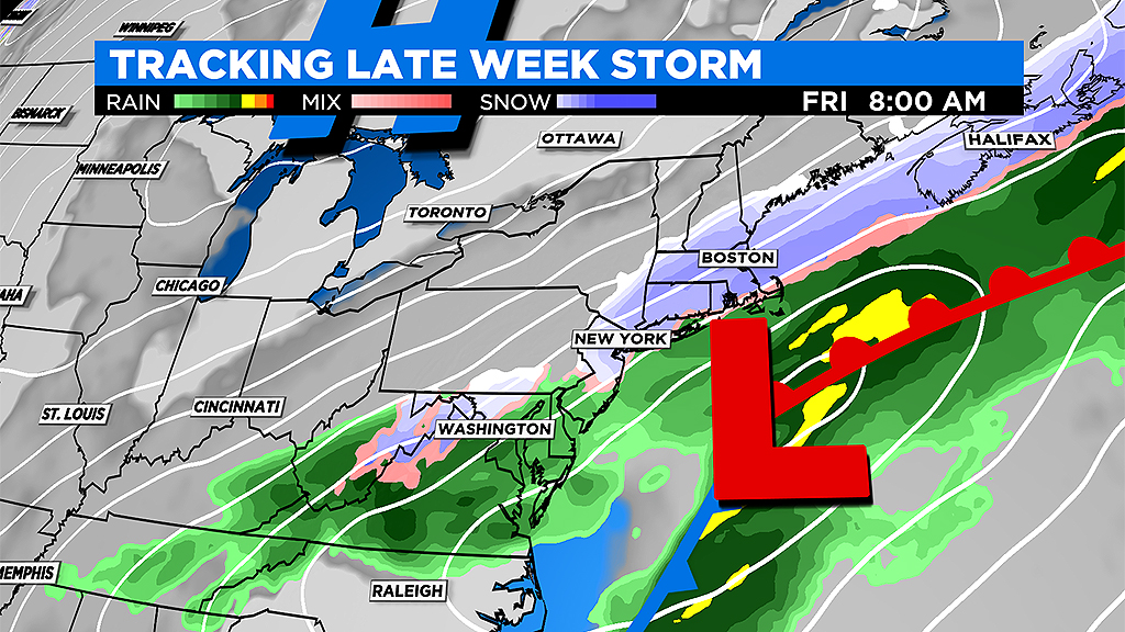
A storm system will be making a cross country trek this week, starting in the deep southwest on Tuesday and pushing east all the way south of New England by Friday. It will bring mainly rain for most folks along its journey, with just some scattered swaths of snow on its very northern fringe from northern Texas to parts of Missouri and Illinois and finally into the Northeast. While it won't be a major snowstorm here, we could call it a mini nor'easter of sorts.
TIMELINE:
RAIN ARRIVES: Thursday afternoon and evening, mainly light.

RAIN CHANGES TO SNOW: First in higher elevations and then from north to south across the entire area, mainly after midnight. This will be the best chance of getting any actual snow accumulation (from about midnight to 7 a.m.). Much more difficult to accumulate snow during daylight hours this late in the season.
SNOW TAPERS from north to south late Friday morning and into the afternoon. The Cape and Islands are the last place to clear out later in the afternoon.
HOW MUCH:
Always tough to predict snow accumulation for late season events. With no current snowpack and a relatively warm ground (it will be mild on Wednesday and Thursday) some of the snow will melt on contact. Also, in the daylight hours on Friday, very little additional accumulation is likely.
However, given that the heaviest snow from this event looks to come between midnight and 7 a.m. and temperatures will be cold enough to support accumulation in that timeframe, it does appear that most of us will wake up to a white landscape Friday. Most models are indicating a fairly high chance of at least an inch of accumulation but a very low risk of 3" or more. So, for now, I would call it a widespread 1-3"in southern New England.
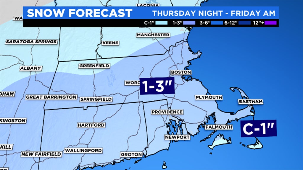
The 1-3" range isn't a ground breaking amount. However, regardless of totals, there will always be impacts when wintry weather returns. The main concern is Friday morning's travel. Slushy accumulation will likely turn into icy spots prior to and around sunrise. The early drive on Friday will no doubt be slower and people should take it easy as they step out. The second half of the day won't be as bad. That said, with afternoon highs staying in the 30s, there may be slick spots for the ride home as well.
BUST POTENTIAL: If the snowfall intensity is lighter and the storm slides a tad farther south or if the timing changes and the heaviest snow comes in the daylight hours, the forecast snowfall would drop to just a coating to an inch or two.
BOOM POTENTIAL: There is a chance if we hold on to the heavy snow intensity for several hours (before dawn) that we could see high end ranges between 3 and 6 inches. This is not our current forecast just a "what if" and high-end potential.
WIND:
We will likely catch the northern edge of the strong wind envelope with this storm. North-northeast wind gusts could reach 45-to-55 mph along the immediate coastline and particularly over Cape Cod and the Islands. Peak winds come after midnight through early afternoon on Friday. No coastal flood concerns as the tides are not high astronomically speaking, although we will keep an eye on the 4 a.m. high tide early Friday.
IS THIS IT?
I will almost certainly regret what I am about to say, but this COULD be it for the snow! The longer range forecast is dominated by milder air and at this time I don't see any shot at additional snowfall through next week. After that, we are nearly in April and at that point, odds favor the season being done (although as noted above, it certainly can snow in April).
Boston is currently sitting at 38.5 inches of snow for the season and our new 30-year average per season in Boston is 48.7 inches. So, short of some late season, April Fools-type surprise, it appears as though this season will go in the books as a below average one.
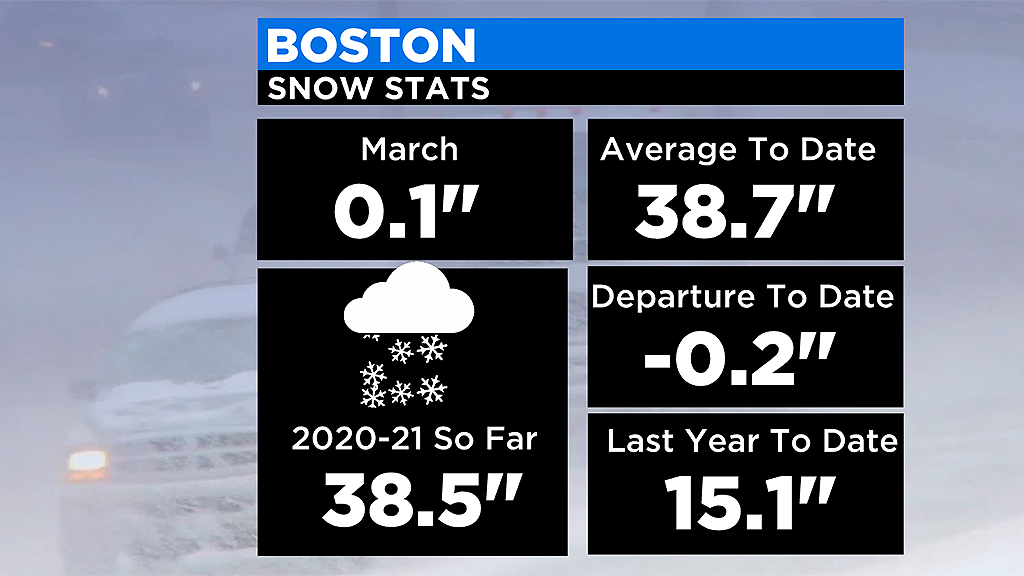
This is not the case everywhere though, Worcester for instance is already a few inches over their total season average, currently with 70.9 inches.
Follow Terry on Twitter @TerryWBZ