Bundle Up For Coldest Stretch Of Weather In Boston In Nearly 2 Years, Possible Storm Next Week
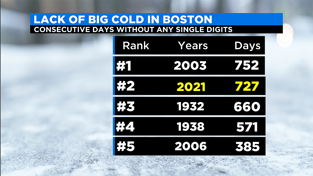
BOSTON (CBS) - How many days this winter would you say have been too unbearable to go outside? A handful? None? January is just about wrapped up and to this point we haven't had any bone-chilling or true Arctic airmasses.
Last weekend was pretty cold I suppose, (30/17 Saturday and 31/16 Sunday), but that was only about 4 degrees below average for the date. And, before that, there was that one stretch in mid-December with similar temperatures, the coldest being Dec. 16th (30/16 for a high and low). That's pretty weak if you ask me for mid-winter in New England.
Last winter was no different. The coldest we got all winter was 12 degrees on February 15th which was followed by several days in the 40s and then a record high 64 degrees a little more than a week later.
To find any REAL cold, you have to go back nearly two years to January of 2019. That month, Boston had 4 days with lows in the single digits, getting as low as 5 degrees on the 21st and 31st.
That is the last example of the kind of cold we are about to feel over the next few days.
Temperatures have gone way down, and to make things worse, the winds have exacerbated the cold, creating wind chills in the double digits below zero.
Timeline:
Temperatures plummeted in Boston from 32 degrees in the late afternoon Thursday down to just 8 early Friday morning.
Add in the winds, gusting 15-30 mph out of the northwest, and we ended up with wind chills of -20 degrees around 8 a.m.
There will be very little relief on Friday. Winds stay busy all day, gusting to 30 mph and high temperatures are stuck in the teens for most of southern New England. Wind chills average between 0 and 10 below during the day. It's the coldest day in this area since Jan 31, 2019 (18/5).
This cold snap isn't the only concern for Massachusetts Friday.
Another round of snow is expected in afternoon. A wave of energy is going to be brushing across the coastal line leading to some significant accumulation in spots.
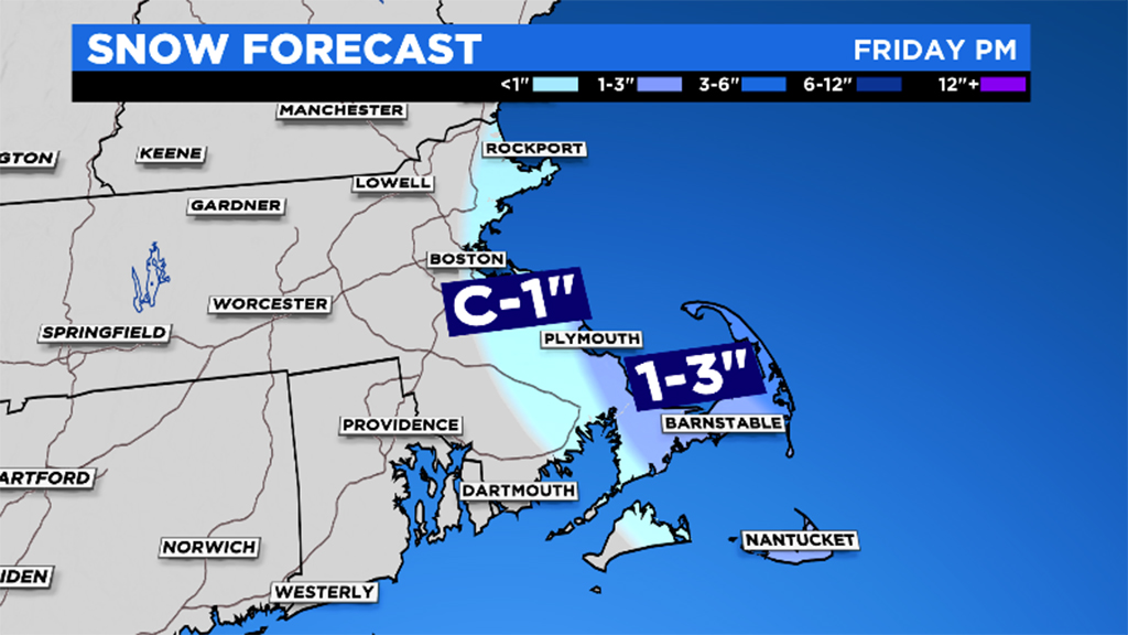
The flakes should start around noon near Cape Ann and will continue to pinwheel southeast during the afternoon. The steadiest bands will line up after 3pm and come down at a good clip between 4 and 6 p.m.
While there is a possibility of a coating for the Route 95/128 corridor, those closer to the water will have a better chance of accumulation. From Cape Ann through Boston and the South Shore, a coating to an inch is possible. Route 3 and eastern Plymouth County likely see similar values. 1-to-3 inches is expected for Cape Cod. The highest totals will be 4 inches for the outer Cape: Provincetown to Chatham.
The main concern will be the evening commute. As wind gusts continue near 30 mph, the snow will lead to reduced visibility and difficult driving conditions. Route 6 on Cape Cod will be the slowest travel, but eastern Massachusetts should tack on a few additional minutes for the ride home.
And don't forget, the bitter cold will continue into the weekend for all of us.
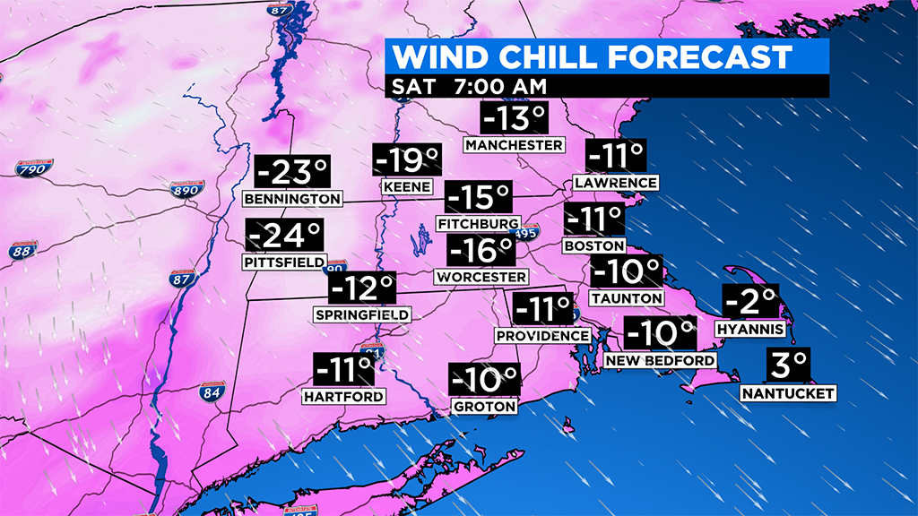
Rest of the Weekend:
Saturday 7 a.m: temps 5-10 degrees, wind chills -15 to 0
Saturday 1 p.m: temps 15-20 degrees, wind chills 5 to 10
Saturday 7 p.m: temps 10-15 degrees, wind chills 0 to 5
Sunday 7 a.m: temps 0-10 degrees, wind chills -10 to 0
Sunday 1 p.m: temps 20-25 degrees, winds light
I'd be remiss if I didn't make mention of the elephant in the weather room before ending this blog.
Models have been fairly consistent in highlighting next Monday and Tuesday for a potential nor'easter here in southern New England.
While it is still way too early for details or certainty, confidence is rising for a highly disruptive, potentially major winter storm. Clearly a situation where you should stay tuned to updates over the weekend, but if current indications are anywhere in the ballpark, this could be a storm which could rival the December nor'easter for snow totals in parts of our area (think 6 inches plus easy, possibly 12").
Groundhog Day snowstorm? Perhaps! Either way, I think this weekend and next week should serve as a reminder that this winter is FAR from over.
Follow Terry on Twitter @TerryWBZ