Big Atmospheric Changes Could Turn Our Quiet Winter Into A Harsh One
BOSTON (CBS) - If you're a lover of snow and winter storms, the current seven-day forecast is likely putting you to sleep. Not a flake or drop in the forecast in the Boston area, or most of New England for that matter, in sight.
I've even gotten a few Tweets from folks asking if this is it. Is winter over? Honestly, I don't even know how to respond to a question like that in early January. I figure it either has to be someone pulling my leg or someone not from New England - I mean come on. We know better. Frankly, many have made the same mistake in early to mid-February before, calling to stick a fork in winter while Mother Nature is simply taking a brief siesta. Frankly, until the Red Sox hit the field at Fenway and the trees start blooming, it is never safe to count winter out here. And even then, it isn't a lock.
This winter has been a bit strange, but aren't they all? While no two winters are ever alike, we try to find the few large-scale factors at the start of each winter that may steer us in one direction or another. This year, the main factor was (and still is) La Nina. A fairly strong La Nina, along with a few other large scale atmospheric hints, led most meteorologists, including us at WBZ-TV, to call for a milder than average winter with less snow than average. And, of course, right off the bat, we were hit with one of our biggest December snowstorms on record. That storm aside, things have gone pretty much as planned. December averaged 1.3 degrees above average and so far January is more than 3 degrees warmer than average. Easy-peasy right?
Well, not so fast.
Here's where we introduce another one of those geeky weather terms, something that may be about to throw a wrench in our winter forecast. I know you've all heard of the Polar Vortex. But, have you heard of the Vortex's grumpy upstairs neighbor, Sudden Stratospheric Warming? Well, let me introduce you.
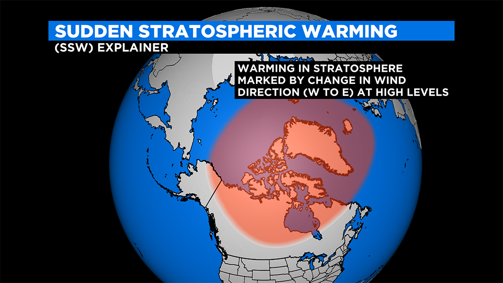
First off, the stratosphere is the layer of air above the troposphere (where we live) extending from about 6 miles to 30 miles above the Earth's surface. While temperatures generally decrease with height in the troposphere, they flip and actually increase with height in the stratosphere. A "sudden stratospheric warming" is a non-rare event in which the winds in the stratosphere switch from their typical western direction to easterly, thus triggering a dramatic warming, many times exceeding 50 degrees Celsius in just a few days! The effects this have on weather around the globe can be quite dramatic.

Essentially, this sudden warming causes a chain reaction in the atmosphere, starting from up above. In general, there exists a ribbon of winds whirling around the Arctic, otherwise known as the Polar Vortex. When these winds remain tight and strong, they help to keep the cold air bottled up around the North Pole. A sudden stratospheric warming event (SSW), causes chaotic changes in the vortex, many times forcing it to split into multiple different vortices which tend to spill southward into parts of Asia, Europe and North America.
Much like we say no two winters are alike, we can also say no two SSWs are alike. Just take the last few years for example. The SSW which occurred in February of 2018 turned an otherwise benign winter into an historical one. We had four nor'easters in the month of March which dropped nearly 2 feet of snow in Boston and caused massive coastal flooding and tree damage.
In contrast, the SSW in January of 2019 had much the opposite effects, leading to anomalous warmth in parts of the U.S. and Europe.
So what effect will this year's SSW have on the Polar Vortex and our weather?
Right now the best we can say is stay tuned.
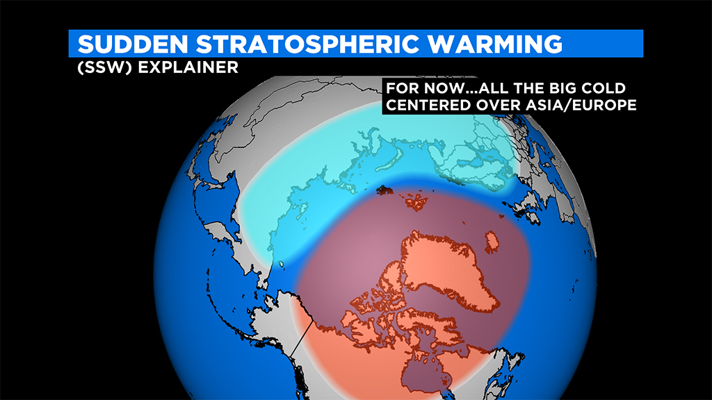
With the event still in its infancy it is nearly impossible to predict the wild undulations that are about to happen as the dominoes fall from the Arctic southward to our latitude. Initially, at least for the next few weeks, it appears as though the most dramatic effects will be across parts of Asia and northern Europe. Harsh cold in response to the SSW is forecast to dive into those areas and you'll likely be hearing reports on the news of record cold and snow from that side of the globe.
Typically, when these disruptions are at their worst, we can get a 30-45 day period of harsh winter weather. For us, the timeframe to watch is clearly the second half of January through the middle of February. Could we descend into another historically cold and snowy stretch? Yes. But, at this point, I would say odds equally favor the worst impacts being on the other side of the globe, while our winter continues to be governed mainly by La Nina and more typical day-to-day variations.
Either way, winter is far from over. Even in the most mild and benign weather patterns, we are bound to get interruptions of cold and snow here and there. The discussion above is merely a "heads up" that big things are happening atmospherically right now. A gigantic bowling ball has been thrown down the atmospheric lane, whether our pins remain standing or not, remains to be seen.
The WBZ-TV weather team will be closely monitoring developments in the coming days and will keep you informed as the pattern evolves. We plan to have a full winter forecast update early in the week of January 18, so stay tuned!
Follow Terry on Twitter @TerryWBZ