'Parade Of Storms' Continues With Snow, Rain To Impact Monday Morning Commute
BOSTON (CBS) - Ready for round two?
The parade of storms and active weather pattern continues for the first weekend of 2021.
We started off the year with a wintry mix Friday night into Saturday, as an area of low pressure pushed through New England. Most snow/sleet totals were around a coating to 2" before changing over to rain Saturday morning.
Boston picked up .51" of rain from the event. It wasn't a big impact but allowed for some slick roadways during the overnight hours.
We only get a brief break in dry weather as our next storm system will be approaching the area late Sunday with another threat of slippery conditions Sunday night into the Monday morning rush hour.
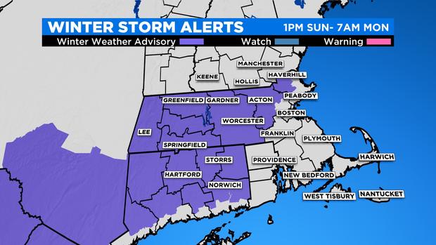
A Winter Weather Advisory has been issued for parts all of Connecticut, western and central Massachusetts, east into western Middlesex and western Essex counties. Travel impacts are expected with snow covered roads.
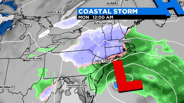
An intensifying coastal storm will emerge off the Mid-Atlantic coast Sunday afternoon and pass south of New England near the benchmark Monday morning. This more classic nor'easter set up will deliver an inland snow/coastal gusty rain scenario. However, this does not look to be a blockbuster event with super high snow totals with the current track. Temperatures will be marginal, meaning just cold enough in some spots for a heavy, dense snow to accumulate.
There may be some compaction and even melting of the snow with surface temperatures near or above freezing at times. There is also still some concern on just how close the system tracks intensity, which will ultimately determine where the highest totals will be and how far south that rain/snow line collapses as the storm pulls away on Monday afternoon.
TIMING
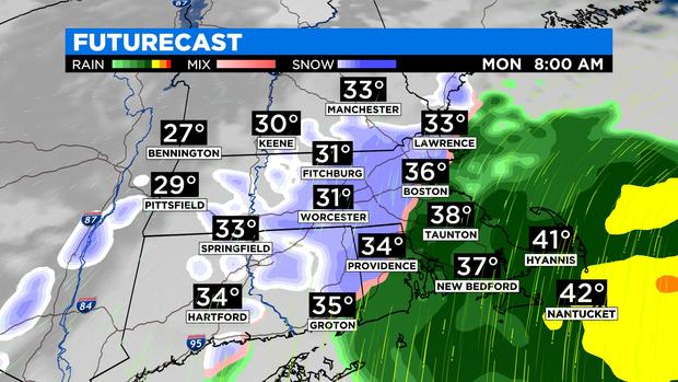
Showers will move in from west to east late Sunday afternoon and evening. Likely to start off as snow for areas west of 495, and rain closer to the coast. Precipitation will pick up overnight with steady snow likely for the Monday morning commute for areas near and west of I-95.
We'll still have to determine the placement of the exact rain/snow line, but it looks to set up in this vicinity. Farther north, there may be a distinct cut-off in precipitation, which is typical as you get away from the center of the storm.
At the immediate coast, a windswept rain is likely for the morning drive. The rain/snow line will then attempt to collapse towards southeast Massachusetts during the morning/midday hours as the storm pushes to the east, but temperatures will be in the mid-to-upper 30s making any snow difficult to accumulate at this point. Showers will linger last over the South Shore and the Cape and Islands Monday afternoon with dry conditions expected by the evening.
RAIN
Rainfall amounts will range from .5" -1" for parts of southeast Massachusetts, along with the Cape and Islands. Highest totals will be closer to the center of the storm.
SNOW
With the current track, most of the area will see a widespread 1-3 inches, with patchy coatings along the immediate coast of the north shore and parts of SE MA. The heaviest snow is expected just west of the rain/snow line. This includes Metro-west through the Merrimack Valley into southern NH, the Worcester Hills and the 495 Belt into northern RI and northeastern CT.
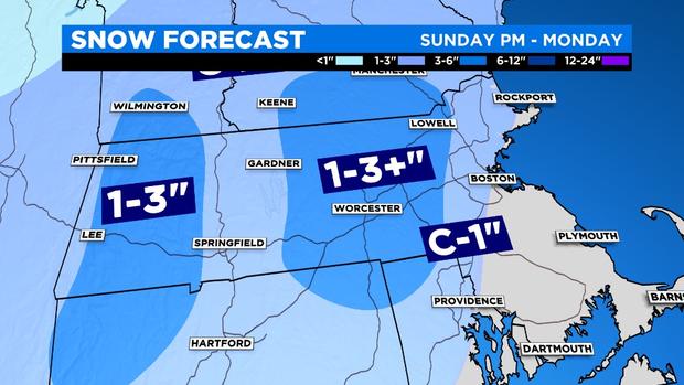
There may be a few towns that overachieve in this area and get 3-5"+, especially at the higher terrain. The consistency of the snow will be heavy and wet that will make it difficult to move. Expect slushy/slippery roads and untreated surfaces. Isolated power outages are possible.
WIND
Northeast winds will increase and become gusty Sunday night into Monday. Gusts are likely to range from 20 to 30 mph, with the strongest gusts over the Cape and Islands. No advisories are in place as damaging winds do not expected this event.
NEXT WEEK
One thing to keep in mind is that this storm doesn't race off quickly Monday night. There will be an atmospheric traffic jam of sorts that will block the system from moving much early next week from the Gulf of Maine.
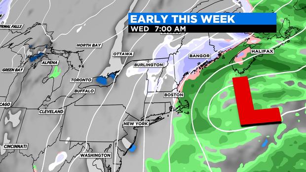
Clouds will stick around for Tuesday and Wednesday with occasional rain/snow showers before improvements arrive later in the week.