Christmas Forecast: Strong Winds, Heavy Rain And Near-Record Warmth For Boston Area
BOSTON (CBS) -- Well for a week we've had the perfect Christmas snow on the ground. It's been festive and has set the mood, but snow is always rented and not owned. It's due to be returned to the atmosphere by Christmas morning. Instead of a White Christmas, this one will be in the most 2020 style imaginable. A soaking, windy, record warm meltdown.
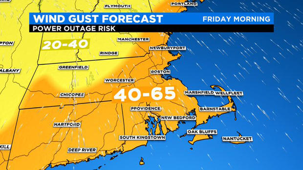
The biggest headline for this extremely unusual storm system is the wind, which will be powered by one of the stronger low-level jet streams you'll ever see this time of year. This is a "river of wind" just a couple thousand feet up, that will be roaring at 75-85 knots on Christmas morning. Not all of that will make it to us on the ground, but widespread 40-65mph gusts from the south are expected with some isolated 65-75mph gusts possible across high terrain (like Blue Hill).
The strongest winds will roar through between roughly 7 a.m. and noon Christmas day, accompanied by very heavy rainfall. It would be a good idea to prepare for a Christmas Day without power, because certainly thousands of people are going to lose it for a time. Power up electronics, have batteries ready to go, and it may be wise to take down some Christmas decorations (inflatables, etc) outside before going to bed Christmas Eve. Also a good idea to avoid parking under trees, if possible.
That wind will be delivering a near-record warm air mass straight from the tropics that will have Santa wearing shorts. We'll soar well into the 50s on Thursday (Christmas Eve Day) and see those readings rise overnight. By the time we start tearing into presents under the tree, some low 60s could push in. This will threaten some all-time Christmas highs in the area, which were just set in 2015.
Coming along for the ride will be exceptionally humid air with dewpoints nearing 60F. Winter dewpoints near 60F have only occurred a few times in the past 140+ years, so this is rare air. Dewpoints like these are also the most efficient way of chewing up snow cover as they help break the icy molecular bonds and chew the snowy landscape apart rapidly. We're expecting a near/total loss of snow cover across southern New England by late Christmas morning.
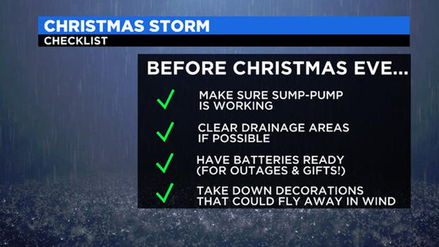
Runoff from that snowmelt will be added to 1-3" of heavy rainfall, steadiest Christmas morning to early afternoon. Lots of poor drainage flooding will be likely, and you'll want to keep a close eye on the basements. Sump pumps will be busy! The rain, plus snowmelt, makes this effectively a 3-4" rainstorm. Rapid rises on smaller rivers and streams will be likely. And don't be surprised to hear rumbles of thunder as a line of downpours and storms will push across by late morning.
When does it all wind down? It looks like the rainfall will slowly push eastward by the evening, with a drying trend overnight. Temperatures will also start to return to normal and will be subfreezing for most of the area by the time we wake up on Saturday. Fortunately, it will be a much quieter weekend with bright skies and highs in the 30s both days.