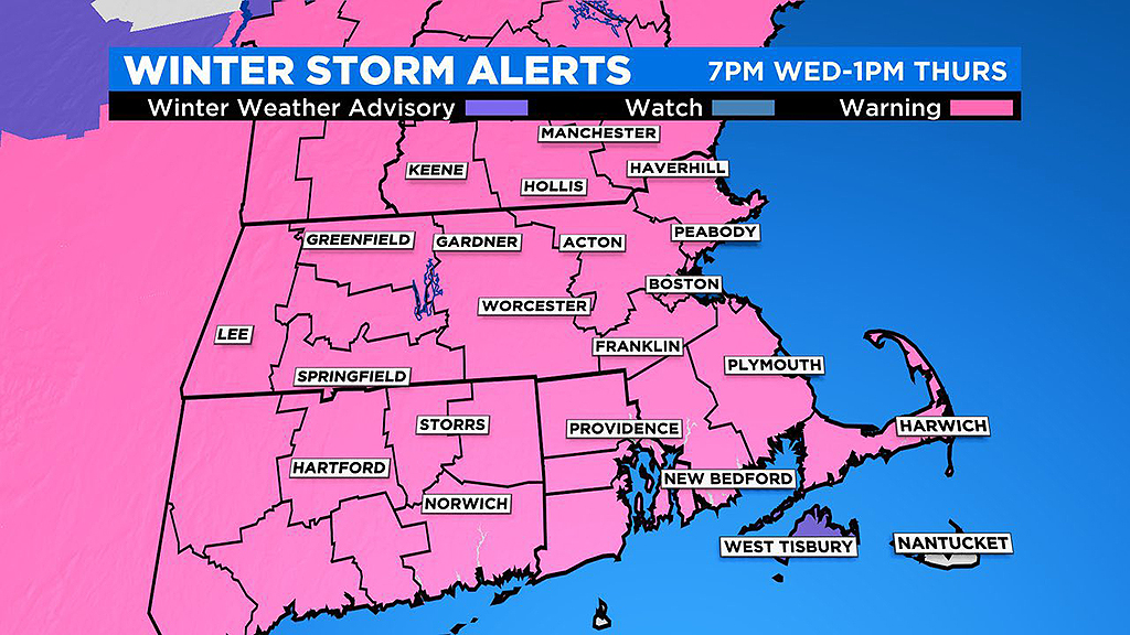
Widespread 10-16 Inches Of Snow Expected In Southern New England Thursday
BOSTON (CBS) - If there is one thing New Englanders know, its weather can change on a dime, and so can the forecast.
If you read my little afternoon blog Monday or perhaps flipped on WBZ-TV and watched Eric Fisher, you heard things like…
-Light and fluffy snowfall for everyone
-Sharp cutoff to the snow shield north of Boston
-Highest snow totals to the south of Boston
That was SO MONDAY…
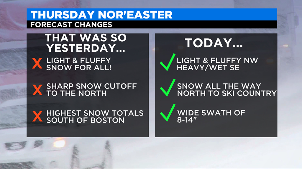
Today those statements read more like this…
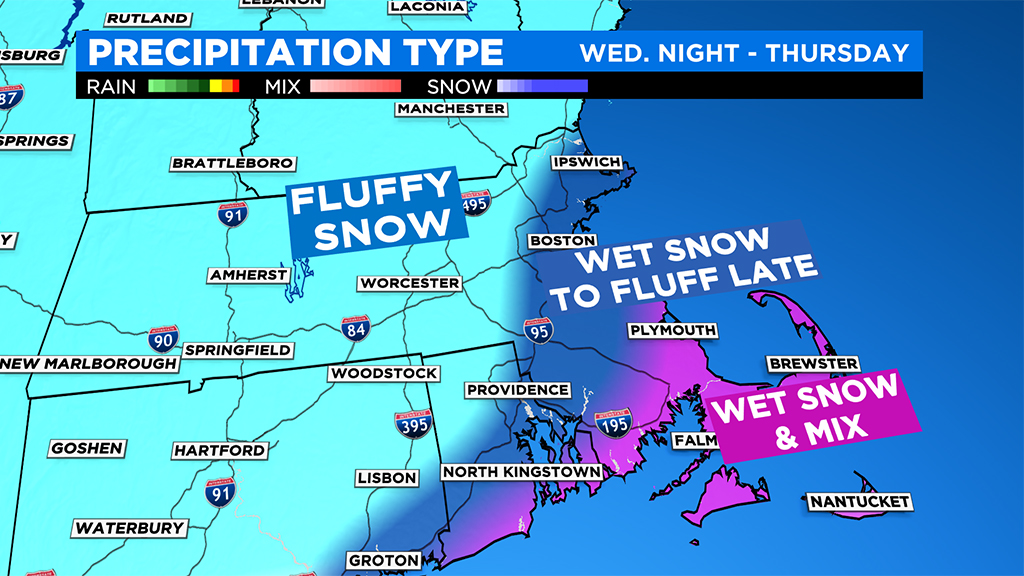
-Light and fluffy snow NORTHWEST OF BOSTON, heavier and wetter along the coast and southeast with some mixing on the Cape and Islands
-The snow shield will likely extend all the way north into SKI COUNTRY!
-WIDE SWATH of 10-16" of snow in southern New England
So, yeah...big changes. Are we done? Time will tell.
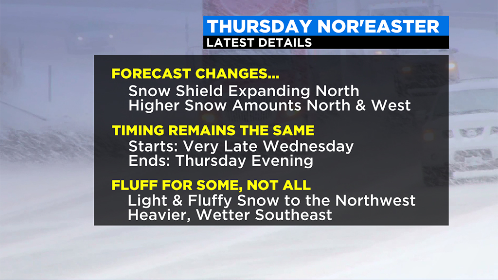
One thing that hasn't changed much, the timeline.
Timeline:
First flakes arrive around 7 p.m. Wednesday in southwest Connecticut and by 11 p.m. in northeast (Essex County) Massachusetts.
Snowfall becomes steady after midnight in all of southern New England.
Heaviest snow falls from about 2 a.m. through 10 a.m. Thursday.
Intensity lessens after 10 a.m., likely done with 80-90% of accumulation at that point.
Between 10 a.m. and 4 p.m. we see scattered light to moderate snow bands, gradually decreasing in coverage.
After 4 p.m. just a few leftover coastal flurries.
Expected Snow Accumulation:
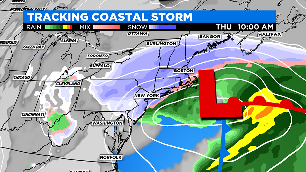
Initial indications showed a sharp cut-off with the snow shield. As of Wednesday morning, the guidance models the WBZ-TV Weather Team uses each day have agreed on a northern push of significant snow accumulation.
Here is the current thinking:
Widespread 10"- 16" across most of southern New England, north of Cape Cod and the South Coast. Major difference here will be in the texture of the snow...light and fluffy stuff west of I-95 and much heavier/wetter snow inside I-95 including the coastline and most of southeastern MA.
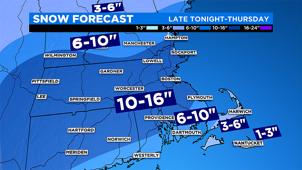
So, while you may get more precipitation to the south (water equivalent), it may end up adding to the same totals in the end. Less water content to the northwest but fluffier snow accumulates much more readily.
6-10" across the South Coast and the Upper Cape near the canal, also including Martha's Vineyard. This due to a very wet snow/mixed precipitation.
6-10" north of Manchester and Keene, New Hampshire…very light and fluffy up there.
3-6" over the Outer Cape
1-3" Nantucket, lots of mixing here
Winds:
Not a hugely powerful storm, so winds will not reach nearly as high as some of our more notable nor'easters in the past.
The strongest winds will be on the outer Cape and Nantucket with gusts as high as 55 mph.
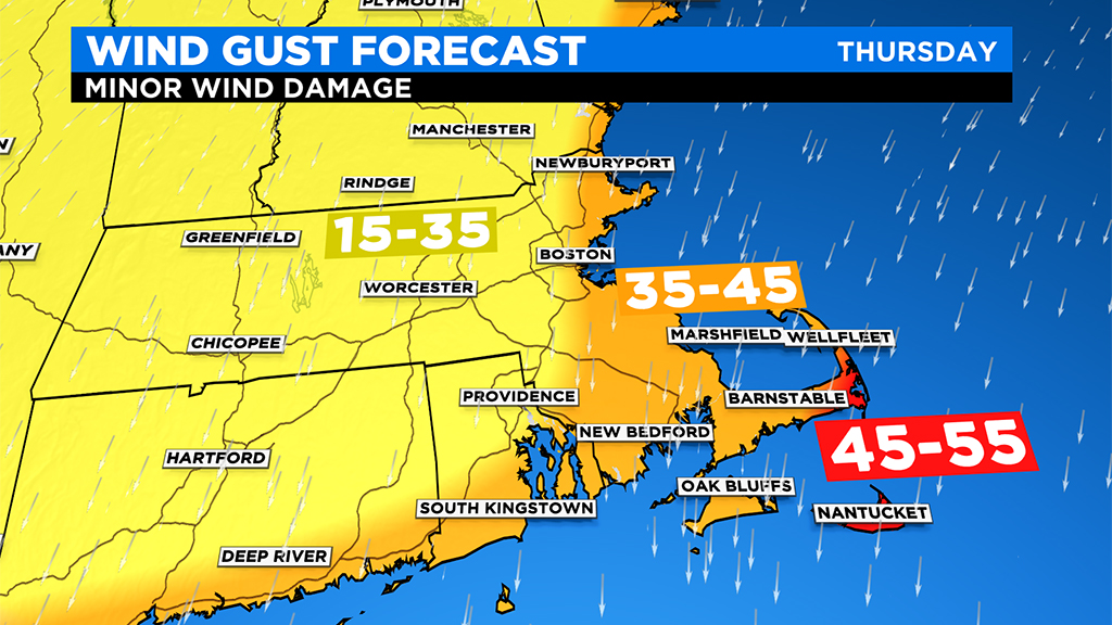
Gusts between 35-45 mph are expected along the remaining coastline.
Inland, much less wind with winds peaking out mostly between 15-35mph.
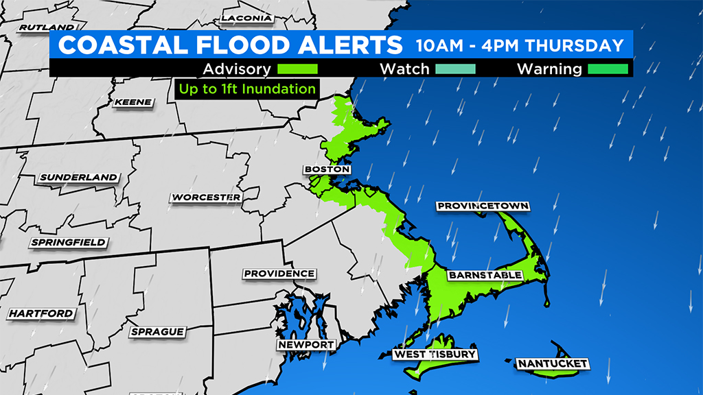
Coastal Flooding:
Tides during the storm will be astronomically high, meaning we will need to be on the lookout for some coastal flooding.
Thankfully, the storms peak occurs during low tide (Thursday morning), so only expecting minor splash over and vulnerable road inundation during the midday high tide on Thursday (12:52 p.m. in Boston).
Travel impacts:
The snow is going to stack up quickly overnight leading to very dangerous road conditions on Thursday morning. Plows and crews will have a hard time keeping up with the accumulation on highways alone. The secondary roads are certainly going to be difficult to manage.
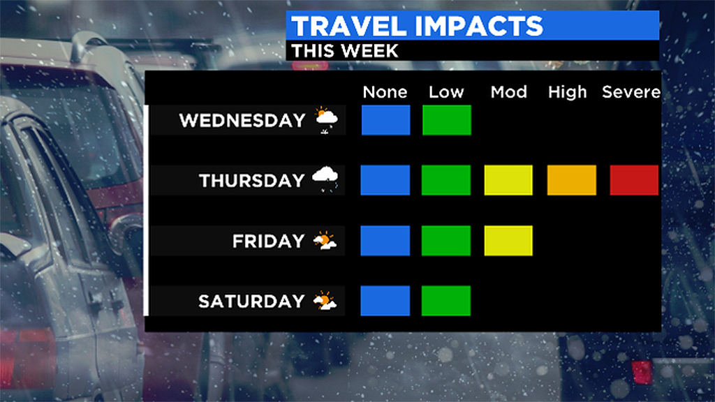
With a "work from home" scenario and "remote learning," the hope is for fewer incidents on the commute. But, if you have to travel, the bottom line will be slow speeds, patience, and safety.
History:
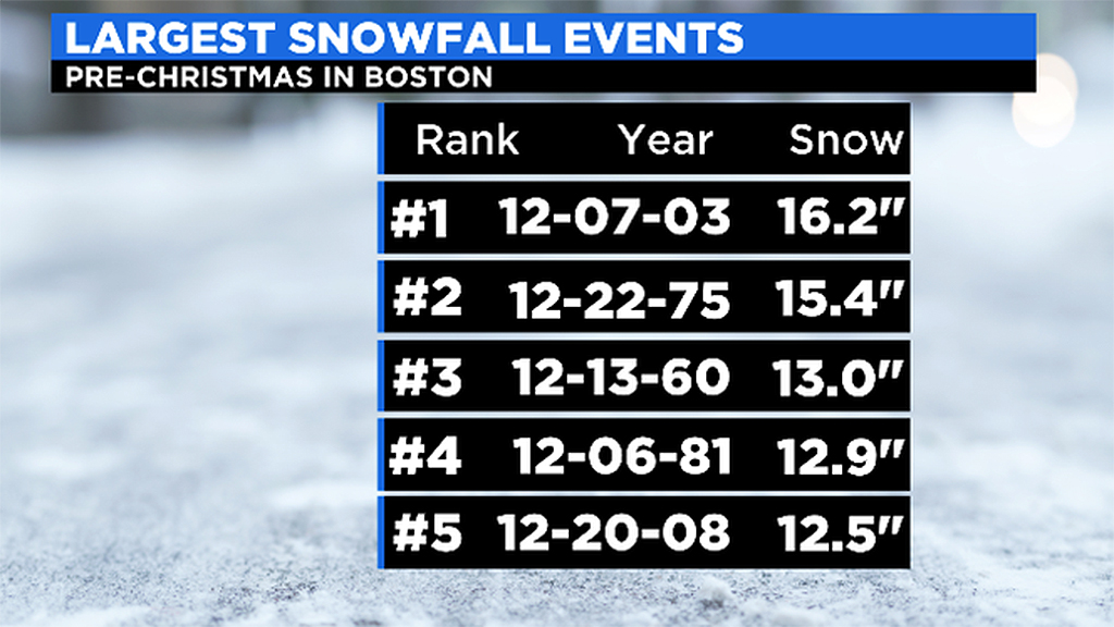
By the way, this storm, as currently forecast, could be one of the biggest pre-Christmas storms ever in Boston! To reach the top 5 Boston would need to get more than 12.5" which was our last "big one" (pre-Christmas) back in 2008. Certainly has been a while since we had a big snow storm before Santa arrived in the city.
As always, we urge that you stay tuned to updated forecasts on WBZ-TV, CBSBoston.com and CBSN Boston leading up to and during the nor'easter.
Follow Terry on Twitter @TerryWBZ