Major Winter Storm Could Bring More Than 16 Inches Of Snow To Massachusetts Thursday
BOSTON (CBS) - Gas up the snowblowers, a major winter snowstorm is headed to Massachusetts!
It has been a while since we have had a storm of this magnitude for our entire area. In fact, you have to go back to March 14, 2018 for the last snowfall in Boston resembling anything like what we are about to receive (Boston got 14.8 inches in that storm).
CHECK: Massachusetts & Southern NH School Closings
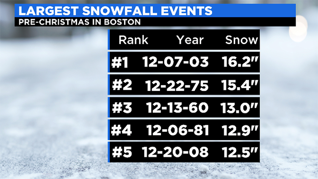
It is even more rare to get a storm of this size before Christmas. The last time we had a foot of snow from a storm pre-Christmas in Boston was back in 2008 (12.5" on December 20).
Worcester had a foot of snow (12.2" to be exact) back in December of 2019, but this storm will likely exceed that as well.
Let's "dig" right in.
TIMELINE:
The first flakes arrive around 6 p.m. Wednesday in southwest Connecticut and by 10 p.m. in northeast (Essex County) Massachusetts.
This storm will deliver a classic "front-end thump" of snow. It will come in like a wall and snowfall rates will almost immediately reach 1-to-2 inches per hour. Roads will become covered and travel will be hazardous within the first few hours.
The first 2-to-5 hours of this storm will likely deliver the heaviest snow of the entire storm and perhaps as much as half the entire forecast accumulation.
By 4-to-5 a.m., the "thump" will be over and the snow will settle in to a moderate and steady intensity for the rest of the morning.
During the afternoon, we will be left with light to moderate snow bands, gradually decreasing in coverage and 80-90 percent of the accumulation will be over by midday Thursday.
After 4 p.m. just a few leftover coastal flurries and it will be cleanup time!
FLASH FREEZE:
We expect a sharp drop in temperatures in places that were near or above freezing for the first part of the storm - this includes parts of Norfolk, Plymouth and Bristol counties.
Late in the morning on Thursday, temperatures will drop from the low to mid 30's into the 20's within a few short hours. Untreated roads and surfaces that were wet will immediately ice up creating an extremely hazardous driving and walking situation.
AMOUNTS:
Widespread 10-to-16 inches:
Across most of southern New England, north of Cape Cod and the South Coast. The major difference here will be in the texture of the snow. It will be light and fluffy stuff west of I-95 and much heavier and wetter inside I-95 including the coastline and most of southeastern Massachusetts. So, while you may get more precipitation to the south (water equivalent), it may end up adding to the same totals in the end. Less water content to the northwest but fluffier snow accumulates much more readily.
6-to-10 inches:
Across the South Coast and the Upper Cape near the canal, also including Martha's Vineyard. This due to a very wet snow and mixed precipitation.
Also the same amounts north of Manchester and Keene, New Hampshire due to less available precipitation, very light and fluffy up there.
3-to-6 inches:
Over the outer Cape and the Vineyard, lots of mixing here
1-to-3 inches:
On Nantucket with a good amount of rain
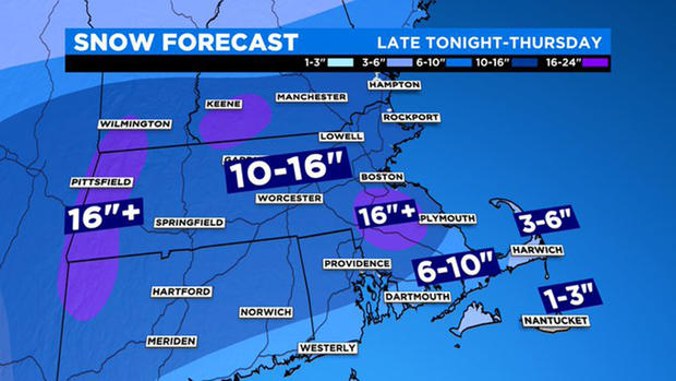
"Hot Zones"
There will likely be a few areas that receive more than 16" of snow due to heavy banding. These are always the toughest to pinpoint but we feel the most likely areas for this event would be:
South and southwest of Boston in parts of Norfolk and northern Plymouth and Bristol counties (due to a big temperature contrast from a coastal front)
Monadnock Region and Berkshires (due to heavy banding and some upslope component with elevation)
These regions could easily top 16" and perhaps get as high as 18" or 20."
2 Feet? If that were to occur, the most likely area would be the Berkshires.
WINDS:
Not a hugely powerful storm, so winds will not reach nearly as high as some of our more notable nor'easters in the past.
The strongest winds will be on the outer Cape and Nantucket with gusts as high as 55 mph.
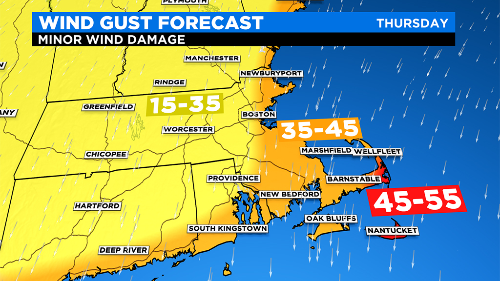
Gusts between 35-45 mph are expected along the remaining coastline.
Inland, much less wind with winds peaking out mostly between 15-35 mph.
COASTAL FLOODING:
Tides during the storm will be astronomically high, meaning we will need to be on the lookout for some coastal flooding. Thankfully, the storms peak occurs during low tide (Thursday morning), so we're only expecting minor splash over and vulnerable road inundation during the midday high tide on Thursday (12:52 p.m. in Boston).
As always, we urge that you stay tuned to updated forecasts on WBZ-TV, CBSBoston.com and CBSN Boston leading up to and during the nor'easter
Follow Terry on Twitter @TerryWBZ