Several Inches Of April Snow To Fall In Central Mass., Boston Area
BOSTON (CBS) - The weather has taken a back seat in recent weeks, and for good reason. Had we been in more "normal" times, no doubt the main topic of discussion would have been how terrible spring in New England is. It is a rite of passage here, before you can get those terrific summer days at the beach, you must endure a long winter and a cold, wet spring (and complain about it every step of the way).
April seems to arrive each year with so much promise, but, in the end, almost always disappoints. I bet you would be surprised to hear that temperatures this April are actually above average right now. While we have had more below average days (8) than above average (6), the milder days have be warm enough to push the month a little less than a degree above average overall.
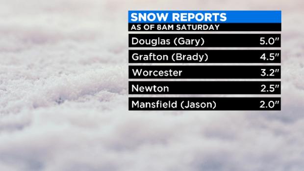
Saturday's early morning snowstorm covered several parts of the state with a few inches.
I bet you would be even more surprised to hear that the amount of precipitation in April has also been about average to date. Put it all together and April has been, well, kinda normal. Essentially this IS April in New England.
What is not "normal" this late in April is snow. Sure a few wet flakes mixing in here and there isn't unheard of, but actual accumulation is truly rare.
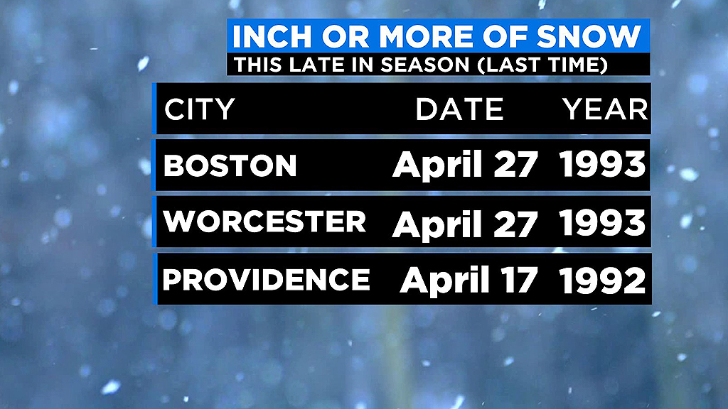
The last time Boston or Worcester got at least an inch of snow this late in the season was back on April 27, 1993! Twenty-seven years ago!
The last time we got any sort of measurable snow in Boston past the mid-point of April was in 2014, April 17-18, when we got 0.3".
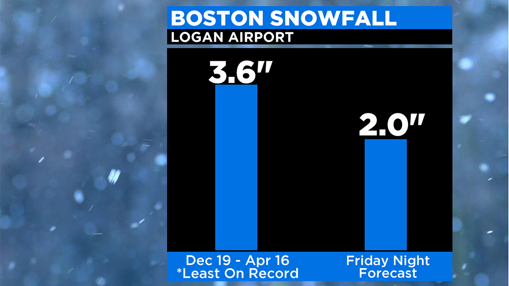
You get it, snow this late is downright unusual. And it feels ever stranger after the extremely mild and snowless winter we have had. In the last 4 months (since Dec. 19), Boston has had only 3.6" of snow, the least amount ever recorded in Boston for that date range. And now, there is a chance, that somewhere not too far from Boston, could receive just as much (or more) Friday night!
Let's not get ahead of ourselves. First things first.
Timeline
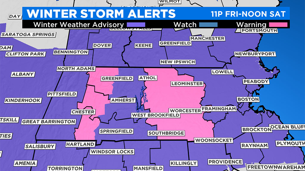
Winter weather advisories were up for most of Southern New England through late morning Saturday. There is a winter storm warning up for Worcester County and the Berkshires, due to heavier snow accumulations in those areas.
Some light rain or snow showers will arrive after 8 p.m. Friday from west to east.
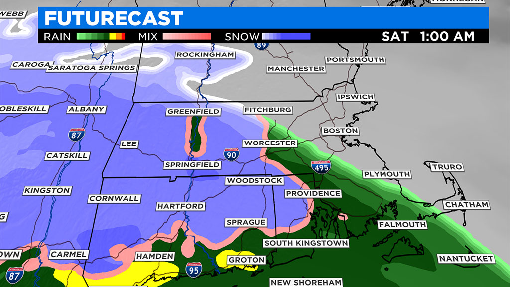
The steadiest precipitation is likely to fall between midnight and 7 a.m. on Saturday. This is when the greatest threat for accumulating snow will occur.
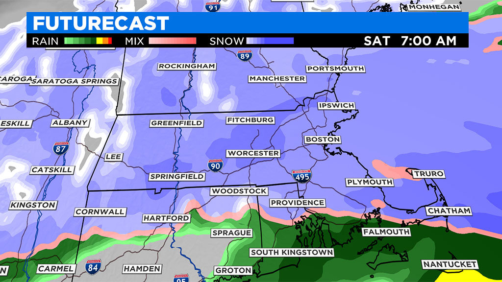
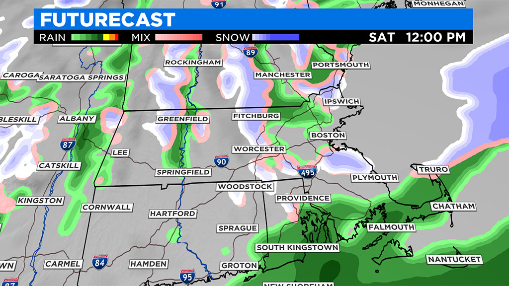
After 7 a.m. the precipitation becomes lighter and spottier, perhaps changing back to a light rain or drizzle in some areas that were mostly snow. By midday Saturday we begin drying out.
Who gets rain, who gets snow
Just about everyone in southern New England will see some snow from this event. However, the South Coast, Cape and Islands will likely mix with rain at times, keeping their snow totals much lower.
How much?
Patchy coatings up to an inch of snow for the South Coast, Cape and Islands. Most of snow will accumulate overnight on non-paved surfaces, before getting washed with a transition back to rain by Saturday morning.
One-to-three inches are forecast along I-95, including the North Shore (Essex County), through Boston and Plymouth and down to the Cape Cod Canal. Most of this accumulation likely is on the grass, especially closer to the coastline.
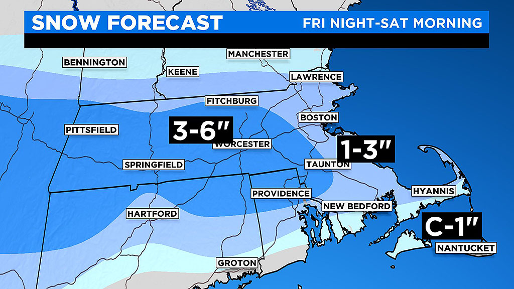
Three-to-six inches will fall north and west of I-95 including Worcester, Lowell and Fitchburg. Areas with some elevation (such as northern Worcester County and the Berkshires) have the best chance of seeing the higher end of the snow range and also stand the best chance at having a significant accumulation on pavement.
The farther eastern areas of this range, such as eastern Middlesex County, are more likely to be closer to 3 inches with most accumulation on grass.
There may be a few isolated locations that record more than 6 inches of snow, but that will be elevation dependent and likely be in "jackpot" spots.
April snow ain't the same as January snow
Getting snow this late in the season means that whatever does fall and accumulate won't be sticking around for very long. I would say 50-75% of the snow will be gone by Saturday night and the rest will go poof on Sunday as we warm well into the 50's.
The snow will be falling with surface temperatures mainly between 32-36 degrees, hence why it is so hard to stick to roads.
I wouldn't waste your time shoveling unless you really want or need the exercise, just wait for Mother Nature to do her thing on Saturday/Sunday.
If all of this has you feeling depressed, I will leave you with this little nugget - long range models are hinting at a significant warmup by NEXT weekend. It is a long way off but there is a chance we could get our first real taste or warm weather - 70's, or perhaps even 80 degrees? Not out of the question, hang in there.