Heavy Rain, Gusty Wind And Power Outages Likely In Monday Storm
BOSTON (CBS) - It is going to be a wild ride with the weather on Monday. Heavy rain, gusty wind and power outages are possible, especially for southeastern Massachusetts.
The National Weather Service in Norton has issued a HIGH WIND WARNING for much of the region starting at noon in western New England then starting around 3 p.m. over eastern areas.
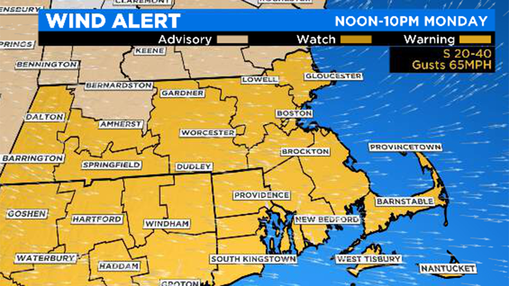
The wind will increase and become strong, gusty and howling in the afternoon from the south at sustained speeds of 20 mph-40 mph with gusts of 55 mph-75 mph over much of central and eastern Massachusetts with jackpot gusts of 65 mph-70 mph over southeastern Massachusetts and southern Rhode Island. Isolated gusts to 75 mph cannot be ruled out!
The wind will decrease from west to east from late afternoon into the evening as the frontal boundary shifts across the area and the warm and rather humid air mass is shoved out to sea. Across most of northern New England, only a WIND ADVISORY is posted due to less powerful gusts anticipated up there.
IMPACT
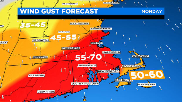
The impact will be high from the gales that may gust to 50 mph-70 mph over eastern New England. Consequently, expect damage to some trees and buildings. Scattered power outages are likely.
The impact will be high from the rain, which will be downpours at times, resulting in ponding on roads where there is poor drainage. Small streams will rise with some minor flooding, but no major river flooding is expected at this point.
The rain will be showery in nature, meaning variable intensity, and at times it may actually stop for a brief spell. There will be a moderate impact from scattered thunderstorms releasing torrential rain in spots with strong wind gusts and dangerous lightning. There is a slight risk that isolated storms may become severe in the afternoon.
The impact should be generally low regarding coastal flooding during the mid-late afternoon high tide. Tides will be churning above average as the seas build, so some splashover and possibly the more vulnerable shore roads will be closed, especially at south-facing coastal locations.
RAINFALL AND TIMING
The rain started to fall before dawn in western New England and shifted eastward into central Massachusetts and into Boston soon after that. It appears that it will be showery with brief breaks between some of the passing showers.
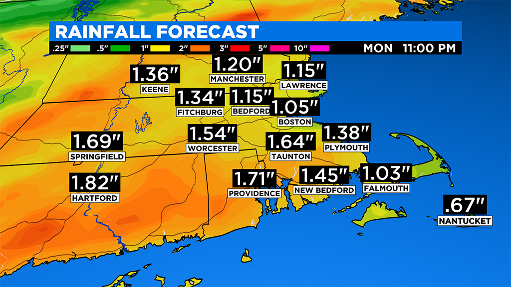
The intensity will vary from sprinkles to torrential downpours. The projected total amounts will generally be in the range of 1"-2" with the greatest amounts over western areas and the least amount over the outer Cape and the Islands. The showers will decrease in intensity and coverage from west to east from late afternoon to mid-evening followed by clearing before midnight.
Quiet weather will follow on Tuesday.


