Boston Weather: Soaking Rain System On The Way
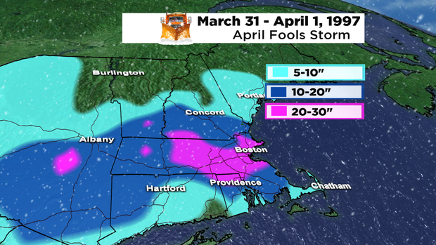
BOSTON (CBS) - No Joke, but on April 1, 1997, the Boston area was digging out of a massive snow storm - one of the biggest in Boston history. Twenty to thirty inches of snow fell from Worcester to Boston during that storm with nearly 700,000 people losing power. Wind gusts ranged from 50 to 70 mph.
Well, we had no big snow storms this year in Boston, and from January to the end of March (typically the snowiest months), the city of Boston saw less than 4 inches of snow. In fact, this period is now the least snowy on record in both Boston and Worcester.
RAINY FINISH TO THE WEEK
A big ocean storm will retrograde into the region on Thursday. Meaning, we'll see rain chances increase through the day from east to west. I expect clouds around Thursday morning, with showers at the coast, but showers will become more widespread and push inland by the afternoon and evening. A few wet snowflakes may even mix in across the higher terrain of northern Worcester county into NH and southern VT.
Steadiest rain will likely continue through early Friday before tapering to showers later in the day, as the storm slowly begins to move east away from the area. Can't even rule out an isolated shower Friday night before this storm finally drifts away. Rainfall amounts will vary depending on location, with western areas seeing anywhere from .25 to .75" of rain, while central to eastern MA will see .75" to 1.50" of rain, with the highest amounts near the coast.
Northerly winds will be strongest on Friday, with widespread gusts of 20 to 30 mph and across eastern MA, gusts 30-40 mph. From the south shore, to the south coast over the Cape and Islands, gusts up to 50 to 55 mph are possible. Isolated tree damage and power outages are possible, so make sure to charge your devices. Temperatures will remain below seasonal normals, with highs in the 40s both Thursday and Friday.
WEEKEND
We'll find gradual improvements over the weekend. As this large ocean storm pulls away, it will turn drier. Saturday will feature clouds around with highs in the 40s at the coast, but inland areas will climb into the low 50s. Skies will average partly to mainly clear Saturday night and temperatures will fall back into the 30s, but a big rebound is expected on Sunday. Under mainly sunny skies, highs, will be closer to normal, if not above with temperatures in the mid to upper 50s. A weak disturbance will be nearby, so we may see a few clouds increase late in the day with light and brief rain chances returning overnight into Monday, but right now that risk looks low.


