After Sunny Weekend, Storm System Could Bring Snow To Parts Of New England
BOSTON (CBS) – After morning showers, clouds are sticking around Friday afternoon. May see a few sunny breaks and some dry periods, but the risk of a shower or two is still possible before a line of organized showers and even thunderstorms later this afternoon and evening as a cold front approaches.
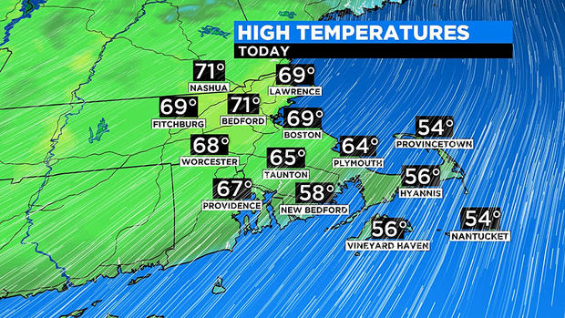
Ahead of this front, gusty southwest winds will bring in warm and muggy air. Temperatures will soar into the 60s at the coast, 70s inland. However, the immediate south coast/Cape and Islands will be a bit cooler in the 50s, but still above normal with that gusty wind blowing over the cooler ocean water.
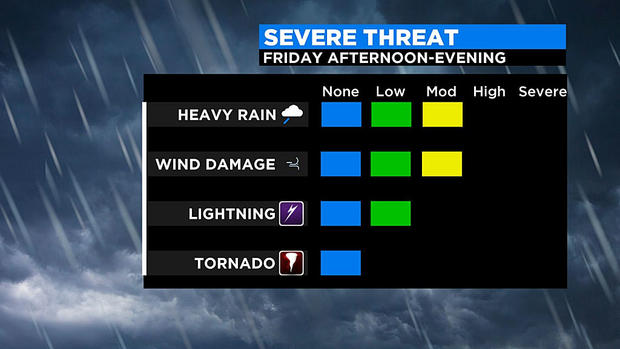
This muggy air will help fuel the threat of thunderstorms later in the day, mainly between 4PM-10PM. The storm prediction center has issued a marginal risk, meaning an isolated strong to severe storm is possible for western New England.
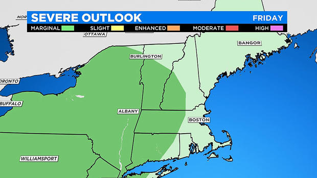
This area includes western and central MA into NH and southern VT. The main threat with any severe storm will be torrential rain, lightning and strong to damaging wind gusts. While rotation is a very low threat, it still can't ruled out with any developing storm.
Keep an eye in the sky for this severe weather threat and if you hear thunder, head indoors. This cold front will move through tonight and introduce much cooler air into the region for the weekend.
WEEKEND
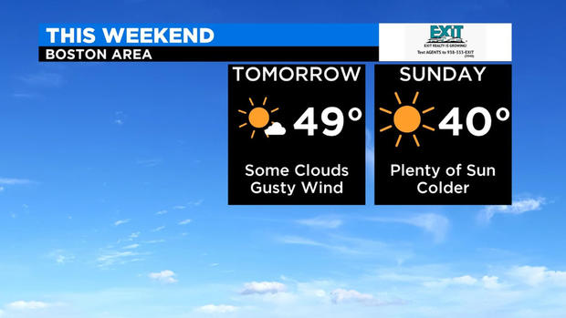
Back to normal. Expect a big drop in temperatures with highs in the upper 40s Saturday afternoon. (Although, that's normal for this time of year!) As high pressure moves in behind our departing front, it will be a breezy day with north winds 10-20 mph. Expect partly to mostly sunny skies.
High pressure will center over New England Saturday night into Sunday leading to quiet, but chilly conditions. Temperatures will continue to fall Saturday night under mostly clear conditions. Expect overnight lows in the teens and 20s. Sunday will be mostly sunny, with afternoon temperatures only climbing into the upper 30s to low 40s.
NEXT WEEK
Monday will start off dry, but as high pressure moves to the east, our next storm system will be approaching the area. It may be cold enough for the risk of a wintry mix.
Rain and snow are possible Monday afternoon/evening into Tuesday as low pressure passes just south of New England. Of course, the exact track will determine the precipitation type and potential amounts, but this is something we are watching.
Showers may linger into early Tuesday before a dry period late in the day into early Wednesday. The dry weather doesn't last long, as another risk of showers moves in by midday Wednesday, exiting the area early Thursday. Highs next week will be in the low 40s on Monday then upper 40s to near 50 through midweek.
Stay with the WBZ weather team as we will continue to update you with the latest information.