Boston Weather: Wednesday Pick Of The Week, Snow & Rain Thursday
BOSTON (CBS) - We have a gorgeous day on tap Wednesday with sunshine and above average temperatures. With more and more people working from home and kids not going to school, today will be a good day to take a break outside if you get the chance.
It will be chilly to start the day, so have an extra layer in the morning. Most temperatures are starting off below freezing, or close to it. Once that sun gets to work, thanks to high pressure in control, the mercury will rebound through the 40s in the late morning and midday to the 50s by the afternoon.
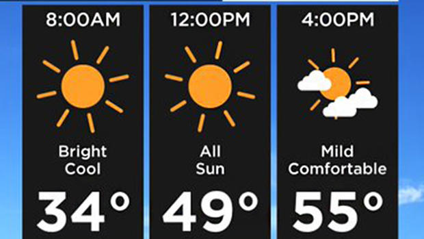
Winds will remain calm, but could mean local sea breezes develop at the coast. Expect highs in the low 50s at the coast, mid to upper 50s inland. Normal high this time of year is in the mid 40s. Expect some high to mid-level clouds to develop through the day, but it will remain dry. If you are headed outside, make sure to grab the sunglasses and sunscreen. Enjoy!
NEXT 24 HOURS
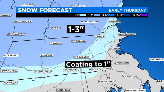
Clouds increase Wednesday night and snow chances return on Thursday. Similar to Tuesday, the snow will have a hard time sticking to the roads. However, expect some minor accumulation on sidewalks, grassy surfaces and car surfaces. A coating to 1 inch is possible between 95 to 495 and areas near and along the Mass Pike, while areas north and west of that could see up to a couple of inches, with the highest amounts across the higher terrain.
The threat moves in after midnight and continues through about 9-10 am. The rain and snow then changeover to all rain by lunchtime as temps warm. We've also got the potential of some heavier rain over southeast Massachusetts as low pressure passes by. Showers should exit by the evening with a bit of break before our next system approaches the area. Highs on Thursday will be a bit cooler in the low to mid 40s, but that is normal for this time of year.
Despite the wintry mix in the morning, Spring officially arrives on Thursday at 11:50 PM. This is the earliest Spring Equinox in 124 years!
FRIDAY WARMUP
A warm front will move through the area Thursday night into Friday morning, with a few showers. As the front lifts northward through New England a surge of warm and muggy air will move in. Southwest winds will become breezy at times with gusts 25 to 35 mph, but that will help push temperatures into the 60s to low 70s. There will be some dry times, but also the risk of a shower, especially in the morning and late in the day ahead of a cold front approaching the area. There may even be a rumble of thunder at times. This cold front will move through Friday night and introduce much cooler air into the region for the weekend.
WEEKEND
Back to normal this weekend. Expect a big drop in temperatures from Friday to Saturday with highs in the upper 40s Saturday afternoon, which is normal for this time of year. Clouds will decrease through the day, while Sunday will be mostly sunny. It will be even cooler on Sunday with afternoon temperatures in the low 40s. At least high pressure will be in control meaning dry and quiet conditions for the weekend.
Stay with the WBZ weather team as we will continue to update you with the latest information.