Nor'easter To Bring Strong Winds, Snow To Southeastern Mass.
BOSTON (CBS) - This one was close…we are just missing out on what would have been a classic New England nor'easter Friday night. It's storms like these that can make or break a winter and this winter has been full of many more misses than hits.
It will not be a complete miss though, it will track just close enough to clip Southeastern MA with some snow and wind.
Here is what to expect…
TIMELINE AND AMOUNTS:
Friday 7 p.m. to 11 pm: Some light rain and snow showers break out over Southeastern MA. Low impact stuff for the most part, no accumulation expected.
Midnight through 8 am Saturday: These are the hours in which the greatest impact will occur. For most of us in southern New England, there will be very little impact at all. Just a few snowflakes and a bit of a gusty wind.
However, a different story over extreme southeastern Mass. as they will be just close enough to the storm to fall within the edge of the envelope of snow and wind. The farther southeast you go, the better chance of steadier snowfall, some snow accumulation and strong winds.

In the Boston to Providence area, expect just some flurries here and there, no accumulation expected.
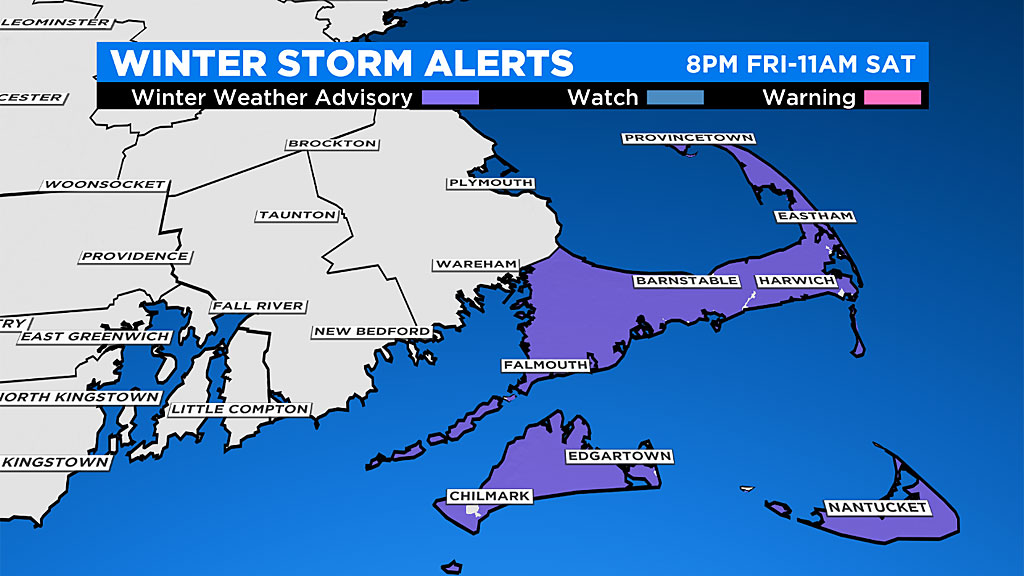
In the Plymouth to New Bedford area, a steadier snow after midnight, dropping scattered coatings to a few inches.
And in the "jackpot" area, the Outer Cape and Nantucket…there could be as much as 2-4" in these areas.
By late morning on Saturday, the band of snow and wind pulls east, completely out to sea, leaving just a gusty, chilly day in its wake.
WIND:
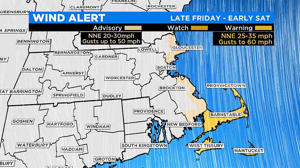
Again, the areas closer to the storm, get much higher, potentially damaging winds.
Late Friday night, east-northeast winds begin to increase with gusts 20-to-40 mph along the coastline and into southeastern Mass. and 40-to-50 mph over the Cape and Islands.
Overnight and into Saturday morning, the winds will veer into the north and peak between 45-to-65 mph on the outer Cape and Islands.
The Plymouth County coastline will see gusts to 50 mph overnight, while the rest of southern New England remains 20-to-40 mph.
The storm roaring offshore on Saturday morning will generate some serious coastal wind. Damages and power outages possible due to the 45-60+mph gusts tomorrow morning. Areas of most concern: Cape Ann, Cape Cod, Nantucket
ROUGH SEAS:
The seas will get mighty angry during this storm with wave heights easily reaching 10-to-20 feet just offshore of the Cape and Islands. Astronomical tides are increasing this weekend but thankfully won't be at their peak until after the storm has passed. The one high tide worth watching for some minor coastal flooding would be the Saturday morning high tide between 8 and 10 a.m., particularly along north and northeast facing beaches (like Cape Cod Bay).
Please stay tuned for updates on WBZ-TV, CBSBoston.com and CBSN Boston before and during the storm.