Why This Year's Snowy Winter Weather Predictions Were A Bust
BOSTON (CBS) -- In November, the spirits of winter lovers were soaring. It was getting cold early. Snow was lurking for the start of December. Most long-range forecasters (the actual ones who do it for a living) all agreed that it looked pretty rocking for the season ahead. But do you know what the proper take at the time was? This one. And I should have gone with the gut.
Yep, the winter outlook was a complete and total bust. It doesn't matter what happens in March. Even if we got 40" of snow I'd consider this a failure of a season considering how little has fallen and how warm it's been. Winter has pretty much been the total opposite of what was expected in every regard. So what the heck happened?
For starters, seasonal forecasting is difficult and imperfect. It's why we start every one with "do not take this too seriously, it's just an educated guess." No one, from NOAA to your favorite private firm or local meteorologist, gets it right all the time. You can say the same about computer models.
This winter though? The computers won. And no one listened to them back in November. Most of the seasonal models had the strong positive Arctic Oscillation and North Atlantic Oscillation that have been a staple over the past several months. Hat tip to the machines.
This begs the question – Why didn't we give them more consideration? It came down to a decision in November. Go with rules of thumb that often can outperform computer guidance…or do we put our faith in the dynamical models that were (in the end) able to sniff out the dominant pattern?
Most of us went with the rules of thumb, and every single one of them failed this year.
The Pacific Ocean
Back in November, all signs pointed toward a weak, centrally based El Nino with sea surface temperatures most similar to winters like 2013-14. The central Pacific was mild and there was a large pool of mild water south of Alaska. There is always some "chicken or the egg" in weather where it's hard to say what forces what. As in, does warm water make the pattern, or does the pattern create the warm water? Most forecasters look at a central-Pacific El Nino and warm North Pacific as a pattern that produces a bunch of jet stream ridging near Alaska.
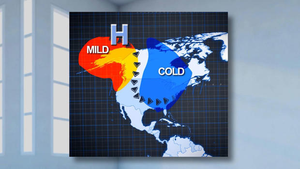
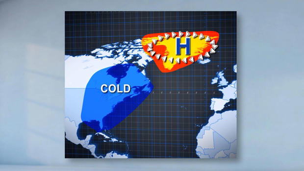
That pattern happened essentially all summer and fall as Alaska continuously shattered heat records. Then we got into December, and it totally flipped. Alaska's ridge went away, the state went into the deep freeze, and we've had very few bouts of the ridge returning for winter primetime. This is also referred to as a +EPO pattern, if you see us reference it online. If you think about a big winter like 2014-15, it was almost entirely driven by the opposite, -EPO.
The Solar Cycle & Blocking
There's quite a bit of research out there that finds some relationship between high-latitude blocking and the sun. A solar cycle runs approximately 11 years from max to max or min to min. We are currently at a notably deep minimum. The relationship shows that when there is a solar minimum with low sunspot activity, there is often an increasing amount of high-latitude blocking. Blocking matters because it helps channel arctic cold down to our part of the globe and can slow down weather patterns, producing bigger storms.
There was indeed high latitude blocking all last summer into fall. And then it, too, disappeared. We have seen the complete opposite with record positive values of the Arctic Oscillation. This means no Greenland blocking, no slow moving and powerful nor'easters. Just a constant parade of +AO and +NAO as the jet stream rips around the hemisphere at a fast clip without many detours. Disastrous if you love snowfall here.
If it makes you feel better, it's been even worse in Europe. Helsinki, in Finland, has had no snow this winter. None. In Russia, Moscow has barely seen a colder than average day since the start of December. The lack of high latitude blocking has been astounding.
The November Rule
This one is simple, and until the last two years almost always worked in the Boston area. What happens during November usually follows in winter. It is an excellent bellwether month.
Going into the season I looked at every November since 2000 that was at least 1 degree Fahrenheit colder or warmer than average in Boston, and then at the following winters. Every significantly warmer than average November has been followed by at or below average snowfall and generally mild temperatures. This includes the 1st, 2nd, 3rd, and 5th warmest winters on record.
Every significantly colder than average November has led to above-average snowfall except one – last year! And now, two in a row.
The Polar Vortex
The polar vortex gets a lot of press, usually when it is weak and breaking down. When that happens and it pairs up with the lower levels of the atmosphere (called coupling) you can get wild intrusions of cold air and, sometimes, snowstorms. March of 2018, with it's four nor'easters, was a result of a major polar vortex disruption that happened in mid-February.
This year? It's a beast. Barely disturbed at any point and hanging around record strength at times. This happens when there aren't any big shots of energy being transferred up into the high latitudes, culminating in stratospheric warming. The polar vortex has not taken any meaningful punches in any of the "right places" to disrupt or split it. This happens from time to time and is not unusual. The warmest winters in the mid-latitudes are usually during strong polar vortex years, like 2011-12.
Problem is, you can't really forecast what the polar vortex is going to do going into winter. There's no way of sitting in November and foreseeing what it will look like in January. So it's a wildcard heading in, and definitely derailed outlooks.
What set the table for it to be so strong? It may have been related to the pattern set up by the warm Indian Ocean last fall (the same pattern that produced the heat and wildfires in Australia).
And here's the rub with the polar vortex. When it's strong in the stratosphere and it "couples" with the troposphere where we live, there's not much that derails it. The positive arctic oscillation/polar jet stream that results lasts a long time. These types of winters that are wire-to-wire mild tend to continue rolling into spring. Eventually, sometime in spring, the polar vortex have a final warming and wind down (it weakens every year as we head toward summer and spins up again in the fall).
So there you go. Everything that usually looks great on paper was a train wreck this winter. It doesn't mean every winter will be more like this going forward. These dud winters happen regularly every 7 to 11 years or so. Of course, climate change favors more mild winters than cold ones but we have not seen any decrease in snowfall yet. As lame as this winter has been, we could get tossed right back into a snowy season again next year. Time will tell!