Long-Duration Storm Will Impact Multiple Commutes With Several Inches Of Snow
BOSTON (CBS) – And away we go. December has arrived and with it, our first winter storm.
This will be a multi-faceted, long-duration, complex winter storm with the potential to make a mess of several commutes and close schools and businesses for multiple days. With a storm like this one, I think it is best to break it down piece-by-piece, day-by-day, hour-by-hour.
PART 1: THINGS GET MESSY, CHANGE TO SLEET AND RAIN
Snow accumulation by dawn on Monday will be heaviest inland of I-95, ranging from 5-10" northwest of I-95 including Worcester, Lowell, and Lawrence as well as southern New Hampshire. We expect 2-5" from Rt 128 to the Coast including Boston and Providence (severely compacted by sleet and rain by morning). A coating to 2" in interior southeastern MA, washed away by morning by sleet and rain. Just rain over the Cape, Islands and South Coast.
PART 2: MONDAY DAYTIME, INCHING ALONG
Nothing major going on Monday morning/midday as the first wave of precipitation is exiting and weakening and we await the next wave. Scattered rain showers at the coast and snow showers inland. There could be an additional inch or two of snow (over several hours) inland of I-95. Plenty of time to get out and clean the roads, sidewalks, and driveways.
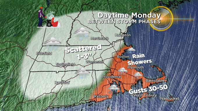
One thing to keep an eye on…late in the day temperatures will drop below freezing in places where it was raining (inside of I95, including Boston and South Shore)…so there could be a flash freezing in these areas between 4-8 p.m.
PART 3: THE WILDCARD, FINAL BURST OF SNOW
The biggest question remaining with this event is what happens late Monday and Tuesday. It looks like the storm system will organize for one final punch, and this one would be all snow. While questions still exist around the intensity of this final wave and location of the heavy snow, there is the potential for several more inches of snow, and more travel headaches. It appears the rain/snow line will collapse back to the Coast Monday night as colder air works back into the system. Many of our models are highlighting eastern/coastal MA as the bullseye for some heavy snow for a 6-10 hour period on Tuesday morning.
Predicting additional snow totals from this final burst of snow is difficult. There is potential for an additional 3-6 inches where the heaviest banding sets up. Right now it appears the immediate Coastline and extreme eastern MA may be within that bullseye. Amounts would taper off farther to the west, away from the Coast. This is certainly not set in stone. Again, the location and intensity of the snow on Tuesday morning is still the biggest wildcard.
OTHER IMPACTS
Other impacts to keep in mind include the wind and coastal flooding. Winds will generally only be a concern at the Coastline (most impactful over Cape Cod and the Islands). Winds will gust 35-55 mph in these areas late Sunday night through Tuesday. They will gradually veer from ENE to NNE to NNW by Tuesday morning.
Thankfully, coastal flooding is only a minor concern thanks to a very low tide cycle currently. Time periods to watch would be between 2-4 a.m. and 2-4 p.m. on Monday and 3-5 a.m. on Tuesday. But again, only minor splash over expected.
We urge that you stay tuned to WBZ-TV, CBSBoston.com and CBSN Boston for updates throughout the storm.
You can follow Terry on Twitter at @TerryWBZ


