December Will Start With Up To A Foot Of Snow, Making Travel Difficult
BOSTON (CBS) -- Tomorrow we turn the calendar page, and there's no denying December starts on a wintry note!
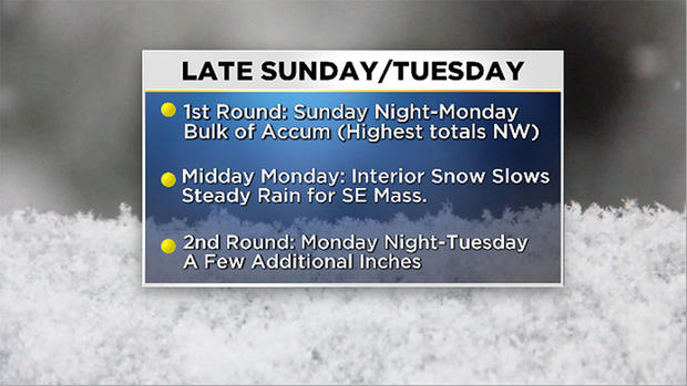
As we've mentioned in previous blogs, there's a window of quiet conditions on Sunday morning. In fact, the snow isn't expected to reach Massachusetts until 2 to 3 p.m. The bulk of the snow arrives late Sunday into early Monday morning. During this time, interior locations could see 1-2 inches per hour!
But there is a harsh transition line which sits just to the northeast of the Interstate 95 corridor. The immediate coastline and southeastern Massachusetts likely sits in rain for most of Monday. So, anything that may have accumulated in the overnight hours will be washed away quickly.
With that said, those along the water aren't done with the snow just yet. Another pulse of cold air will give another shot of snow from late Monday into Tuesday morning. While this doesn't have the same intensity as Sunday-Monday, it could produce an additional few inches through midday.
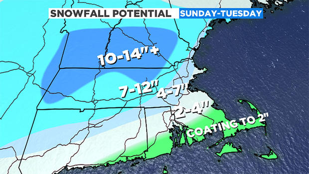
The snow totals have remained more or less the same, however the trickiest location still seems to be from Boston to MetroWest. Those closer to the water will be on the lower end of the accumulation due to onshore winds, and there will be a rather steep increase as you move west. Highest values still expected in the Worcester Hills with areas north of Route 2 possibly seeing 12 to 15 inches. Southeastern Massachusetts is still expected to receive the lowest amounts with the Cape and Islands in a mainly rain event.
A little side note about Boston's expected snow-- we could see daily accumulation records on Sunday and Monday! The one-day record for Dec. 1 was set in 1940 and currently stands at 1 inch. Dec. 2's record is 6 inches, and was recorded in 1929. While I do think the 6 inch value will be hard to reach on the Monday, we'll get close to these values!
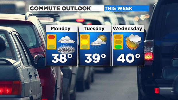
Travel is still the main focus in regard to potential impacts with this storm. Monday is undoubtedly going to be the worst, with slippery roads and some reduced visibility due to the continuous snow and rain. As that second round returns Monday night, Tuesday morning's drive will look very similar. So we can expect another batch of school delays on Tuesday and this is going be clogging up the primary and secondary roads. We'll finally see traffic times return to normal on Wednesday when this system is finally wrapped up.
The WBZ Weather Team is working around the clock to keep you in the know! Be sure to tune into WBZ and you can always find the latest forecast on CBSN Boston.


