Snowstorm To Bring Foot Of Snow To Parts Of Mass. And NH
BOSTON (CBS) -- Gas up the snowblowers, dig out the shovels, boots and winter gear...winter is about to get real!
Are you ready? It's been more than 270 days since our last battle with a significant snowstorm (March 4 to be exact), so we may all be a bit rusty. Not to mention it took us until Jan. 20 to get our first inch of snow on the ground in Boston last winter, and that March 4 storm was the one and only real storm (producing more than 6 inches) of the entire season! While there is time for track changes and adjustments, the sheer size, timing and duration of this impending storm clearly warrant an early heads up. Here's a look at the concerns with the first significant storm of the season.
HEADING HOME FROM THE HOLIDAY:
There's no doubt Saturday is the pick of the weekend for travel. However, if you're looking to stay an extra night, leaving Sunday morning won't be a hassle. With that said, you should give yourself enough time to ultimately get to your final destination before the snow showers start, which brings us to the timing of this system.
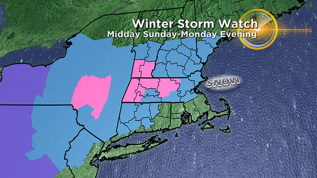
TIMING:
It starts snowing light to moderate between 2-5 p.m. on Sunday in southern New England. Should start as snow just about everywhere. I would plan on getting to your final destination by mid-afternoon Sunday...certainly by dark. The snow ramps up in intensity after dark and really comes down hard overnight Sunday night into Monday morning (this is the brunt or peak of the storm). I would estimate about 75% of the total snow will fall between 8 p.m. Sunday and 8 a.m. Monday. If the current forecast holds, kids will all be receiving an extra day off on Monday. I highly doubt many schools and businesses in the "snow zone" will be open.
Between Midnight and 7 a.m. Monday, there will likely be a change from snow to a mix and rain over southeastern Massachusetts. The change starts first on Cape Cod and the Islands and then slowly pushes northward to just about Boston by dawn. This will keep snow amounts lower in those areas.
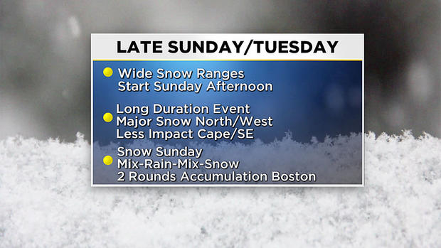
During the day on Monday, the rain snow line sits right around Interstate 95, bringing mainly rain along the immediate Coastline and over southeast Massachusetts, and mainly snow inland (north and west of Interstate 95). The precipitation will not be nearly as heavy as it was overnight, now coming in spurts and of a more showery nature. There will be some additional snow accumulation inland during the day on Monday, but it will be at a much slower rate, perhaps an inch every 2-3 hours.
Believe it or not the storm will still be going Monday night, not completely tapering off until sometime Tuesday morning. Another day of no school? Perhaps. The rain/snow line will collapse back southeast, changing the rain showers back to snow showers Monday night along the coast and over the Cape. Additional few inches of snow possible across the area by Tuesday at dawn.
HOW MUCH:
Still a bit early for exact, zone by zone, forecast snow amounts but the potential is there for some areas to receive a foot or more from this storm.
Jackpot snow zones will likely be north and west of Interstate 95, this includes much of Middlesex and Worcester counties and also inland Essex county. Southern New Hampshire will also be in the heavy snow zone. Again, there could be AT LEAST 7 to 12 inches in these areas, and if all falls just right (or wrong depending on your point of view), with some recording upwards of 15 inches!
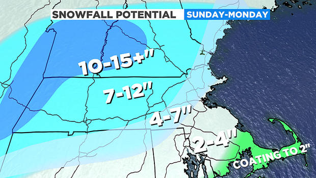
The city of Boston and immediate North and South Shores will pile up the majority of their snowfall on Sunday afternoon and night, before changing and mixing with rain. There will likely be a few inch difference between immediate coastal spots in the city and those just to the west of Boston due to an onshore wind. So while Logan likely records close to 6 inches, some areas around the city (i.e. Seaport) may see lower values.
Lowest snow amounts will be found over southeastern Massachusetts, Cape Cod and the Islands. Northern Bristol and Plymouth Counties should see values around 6 inches, but as the snow changes to rain Monday morning I would plan on 4 inches or less as you continue south and east. The lowest amounts expected for the Outer Cape and Islands.
OTHER CONCERNS:
Thankfully, this storm arrives at a time of astronomically low tides. However, given the long duration of the event, there could still be some minor coastal flooding around the times of high tide. We will be watching the coast between 2-4 a.m. and 2-4 p.m. on Monday.
Winds will be gusty along the coast and Cape/Islands late Sunday night through early Tuesday morning. Expect east-northeast wind gusts 20-25 mph for many and 35+mph for coastal locations. By Tuesday morning winds will shift to the north and eventually northwest and begin to gradually taper down.
Can't stress enough the importance to stay tuned to forecast updates this weekend, especially if you plan on traveling Sunday. We have you covered on WBZ-TV, CBSBoston.com and CBSN Boston.


