Winter Outlook: Snowiest Season In Years Predicted By WBZ Weather Team
BOSTON (CBS) - The sun is low, the air is cold, and the first flakes have fluttered to the ground. Another New England winter is upon us, but much like snowflakes, no two are alike.
Our WBZ Winter Outlook comes with all the caveats of a long range seasonal forecast. It's a budding science, and is by no means a guarantee of what's to come. Our viewers have always had such a strong interest in the science behind our atmosphere and what the winter season will bring. For that reason we embark on an effort to make our best educated prediction of what may come over the next few months. Some years they've been excellent! Others (last year), not so much. So take it for what it is - a journey to learn about what drives our atmosphere and how it may affect our signature season in New England.
PREVIOUS WINTERS
For starters, let's take a look at our previous winters. They have been keeping records in Boston since the 1870s and at Blue Hill Observatory since the 1890s, so we have a pretty solid data set of past seasons to look through. A full winter has delivered as little as 9 inches of snow or as much as 111 inches! That's a pretty wide spread of outcomes. Interestingly, our snowiest (2014-15) and our 2nd least snowy (2011-12) have both occurred in the past few years.
THE PACIFIC OCEAN'S IMPACT
One of the first places we look for clues every year is the Pacific Ocean. Covering over 30 percent of the earth, it's a huge driver of the weather. But this year we find no significant El Nino or its cooler counterpart, La Nina. Instead, a general pool of warmer than average water in the central and north Pacific, which we could consider a weak centrally-based El Nino. This generally resembles recent winters like last year's and 2013-14.
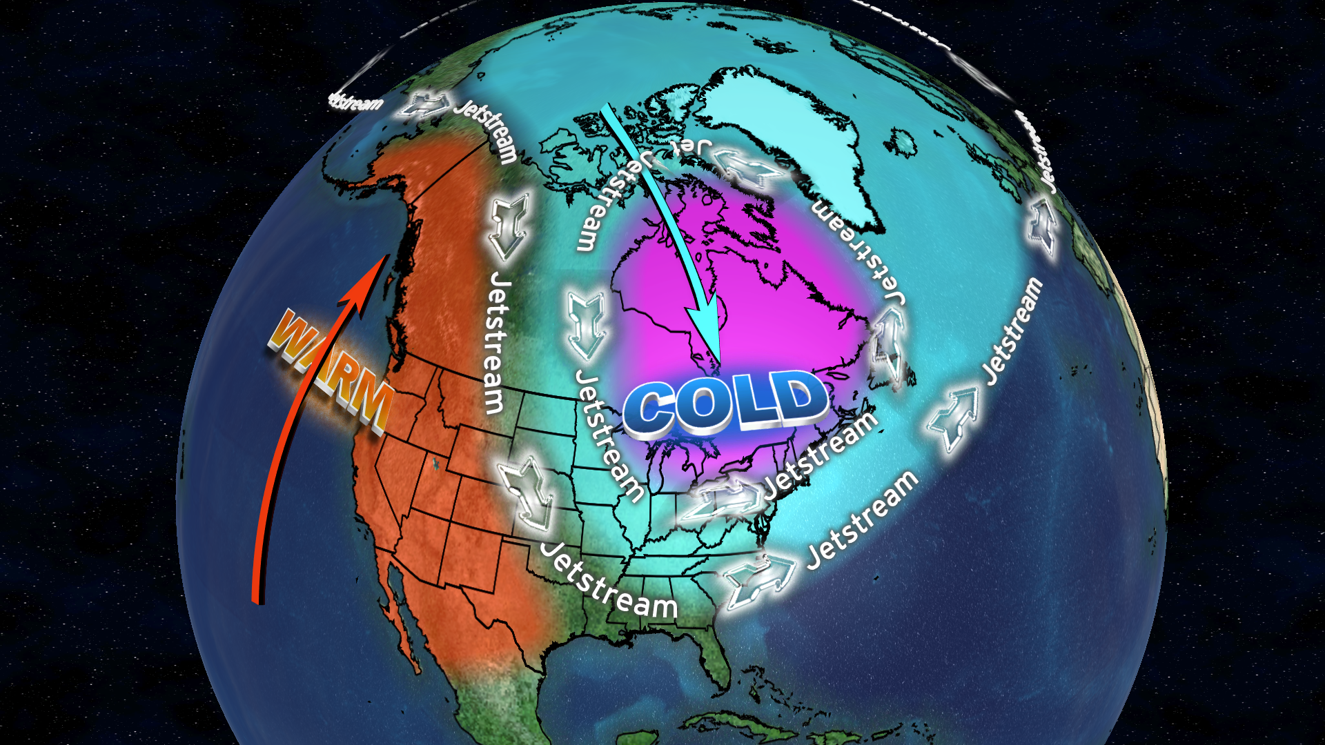
That warmer North Pacific is in tandem with record low arctic sea ice, dramatically so around Alaska, and that can be a big variable for us. This October, there was an area of open water the size of Argentina that used to be ice covered at that time of year just a couple decades ago.
Massive sea ice loss may be helping to drive a pattern that sends arctic blasts our way in a counter-intuitive atmospheric dance. It's difficult to think of a warming arctic as producing colder outcomes down here where we live, but research suggests that may be what's taking place, especially in mid to late autumn where the unusual amounts of open water are a factor before icing over. The past few years have certainly seen some big arctic outbreaks early in the season, while places like Alaska see record warmth.
THE SOLAR CYCLE & BLOCKING
Something that may be surprising to hear is that the solar cycle can also have an impact on our winter. Solar cycles last approximately 11 years, and we are at the bottom of cycle 24. That means very few sunspots.
Why does it matter? Research shows that winter can often feature more high-latitude blocking during these minimums, which in turn can mean colder and stormier weather down below where we live. When we say 'blocking' we are looking at ridges of high pressure in places like the arctic and around Greenland that slow down the pattern and can help produce stronger, slower moving storms near us. There is another atmospheric player called the QBO (Quasi-Biennial Oscillation) that is also set up to favor more high-latitude blocking this winter.
THE NOVEMBER RULE
A simpler yet useful rule of thumb locally is the so-called November Rule - meaning, what happens in November usually follows in winter. This rule has worked out nearly perfectly over the past couple of decades. I don't like to go much farther back for analogs because our climate has changed to the point of making them a bit less useful, particularly when it comes to arctic amplification.
I looked at every November since 2000 that was at least 1 degree Fahrenheit colder or warmer than average in Boston, and then at the following winters. Every significantly warmer than average November has been followed by at or below average snowfall and generally mild temperatures. This includes the 1st, 2nd, 3rd, and 5th warmest winters on record.
Every significantly colder than average November has led to above average snowfall except one – last year! That being said, we only missed it by about 70 miles. Central and northern New England had a huge winter of snow and cold while we barely mustered a whimper down in southern New England. This goes to show you why seasonal outlooks can be difficult. It's a game of miles. A couple big storms hit and we have a snowy season. A couple miss and it's a dud. Pretty much just comes down to that every year.
THE POLAR VORTEX WILDCARD
There is always the wildcard of the polar vortex, but it is difficult to forecast with much lead-time. The polar vortex is a river of fast-moving winds very high up in the atmosphere that strengthens during the winter and weakens during the summer months. There are occasions when energy is sent poleward and the stratosphere warms quickly, called a sudden stratospheric warming or SSW. These can disrupt or even split the polar vortex, which is something that has occurred several times in recent winters. When it happens, patterns can get stagnant and extremes can develop.
We will see if one occurs this winter, but general rule of thumb is that it takes about two weeks to get any influence down to the surface, and then it lasts for 4-8 weeks. It is a very slow moving aspect of winter forecasting, but can leave a mark - think March 2018 and the four'easters.
DRUM ROLL…. THE WINTER OUTLOOK
Which brings us to our winter outlook. While last year bucked the trend, it is hard to argue against the overall pattern of the past couple decades. We expect a colder than average winter with above average snowfall, with the highest snowfall potential in January and February.
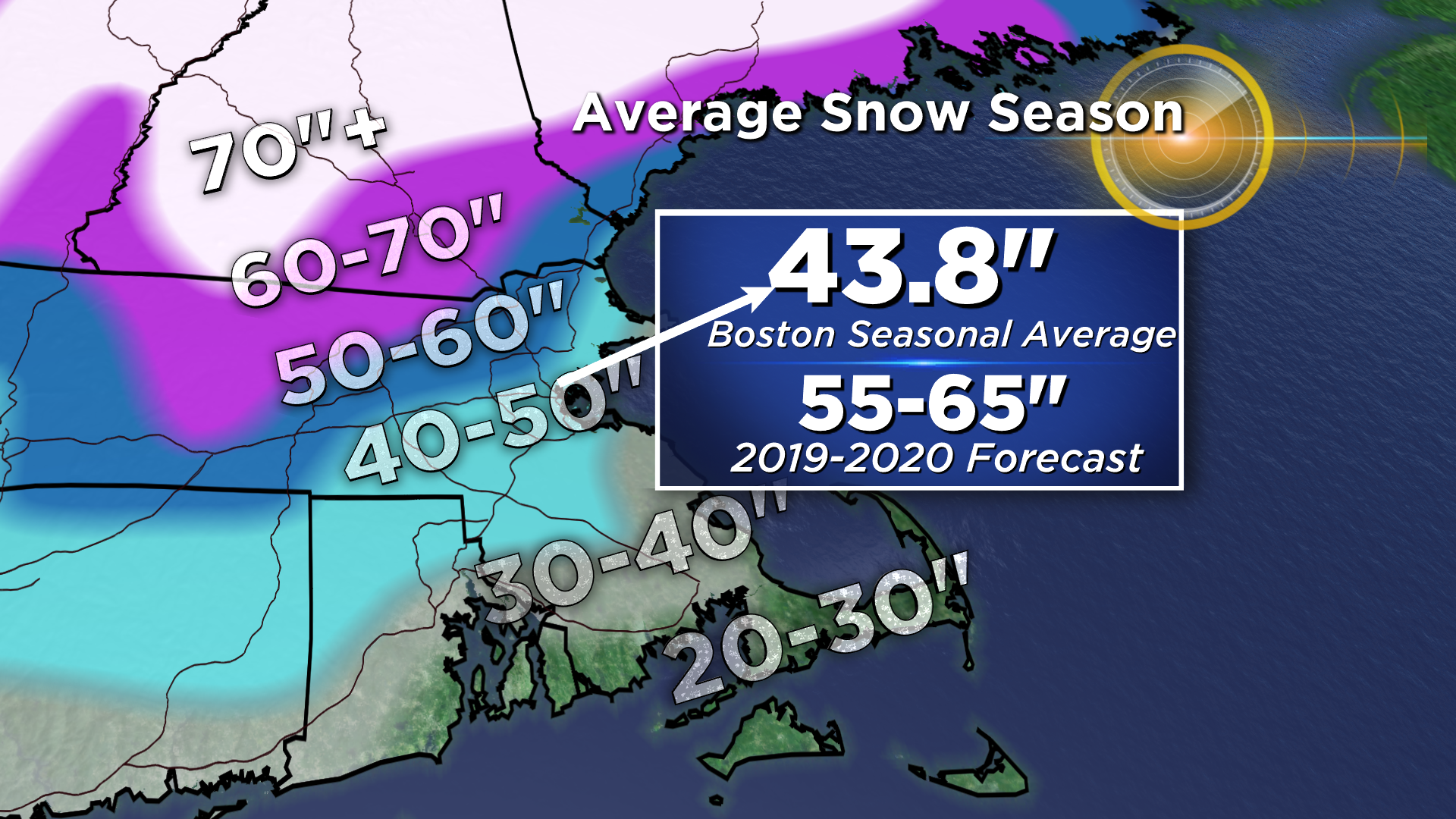
For the Boston area, the WBZ Weather Team is calling for 55-65 inches of snow through April, with 70-80 inches across the typical snow belts west of 495 into central Massachusetts. Overall, we think it will be the snowiest winter since that epic 2015 run, though not nearly to that level! We may not see something like that again for a generation or two.