Raging Nor'easter Hammers Parts Of New England With Wind And Rain
BOSTON (CBS) – A wide range of weather conditions is expected throughout our area over the next 48 hours. A raging nor'easter for some and just a cool, cloudy, breezy day for others. This storm is all about location, location, location.
The area of highest impact will be southeastern Massachusetts, most notably Cape Cod and the Islands. This is where the highest amounts of rain and wind will occur and therefore the greatest risk for wind damage and scattered outages.
The next area of greatest impact is along the coastline, from the South Shore, through Boston and up through the North Shore and N.H./Maine. In these areas, waves of showers and times of gusty winds (as high as 40-50mph) will occur through early Friday. Slightly less dramatic than Cape Cod/Islands, but still a nor'easter feel at times.
Finally, for areas inland of Interstate 95, and certainly inland of I-495, this will just be a chilly, damp and breezy stretch. More of a nuisance than anything else. Rain amounts less than an inch and wind gusts generally below 40mph (and many will stay below 30 mph).
TIMELINE
Thursday will bring the strongest winds and heaviest rain to southeastern Massachusetts. The peak wind gusts and majority of the rain will fall during Thursday.
On Friday, the storm will begin to weaken and finally start to slowly move eastward (out to sea) as it is "kicked" away by an approaching cold front from the west. That being said, conditions will still be miserable on Friday - damp, cold, and windy. But the winds will slowly decrease from their peak levels on Thursday and the rain will become more showery and drizzly in nature.
The last gasp of this storm in our area comes Saturday morning. Our holiday weekend will start damp and dreary Saturday morning but conditions will be vastly improved by afternoon, with sunshine emerging from west to east.
RAINFALL
The highest rainfall amounts will come in areas closest to the storm, namely in southeastern Massachusetts. We are currently forecasting an additional 2-3 inches from Plymouth southward, including Cape Cod, the Islands and the South Coast.
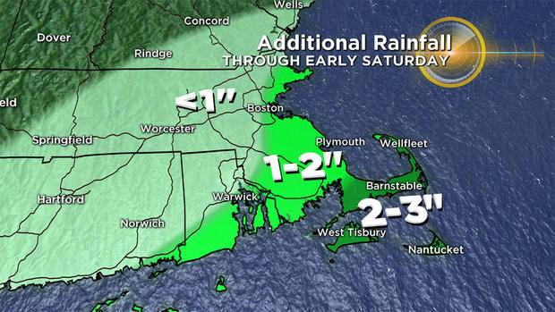
An additional 1-2 inches are likely in parts of northern Bristol and northern Plymouth counties. Amounts drop off sharply the farther north and west you travel - about another inch or so in Boston and less than that anywhere north and west of 495.
There is a flash flood watch up for Plymouth, Bristol, Barnstable, Dukes and Nantucket counties through Friday morning. This is for the potential for some localized fresh water (inland) flooding.
WINDS
Same deal here, biggest impact in southeastern New England.
Peak gusts:
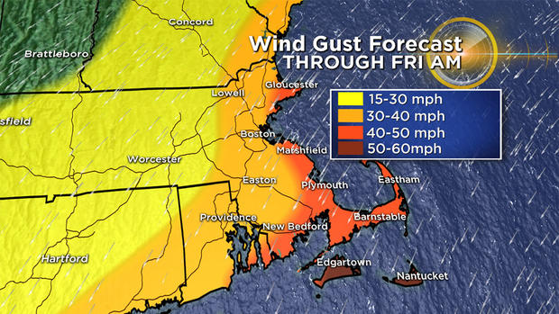
50-60 mph most of Cape Cod and the Islands, perhaps a bit higher then 60 mph on Nantucket
40-50 mph on the immediate coastline including the North Shore, South Shore and South Coasts and Metro Boston
30-40 mph all of inland eastern Massachusetts (inside of 495)
15-30 mph north and west of 495 (big drop off here)
There will likely be some wind damage to trees and power lines along the immediate Coastline and particularly over Cape Cod and the Islands, hence the National Weather Service has issued a high wind watch for these areas through early Friday.
WAVES AND SURF
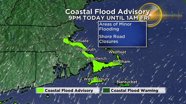
With the storm just sitting and spinning for days, our coastline will be lashed with a long fetch of persistent east/northeast winds. Several successive tide cycles will be affected. Thankfully, the tides are NOT astronomically very high (otherwise this could have been a very serious situation at the Coastline).
However, even with the relative low tide cycle we are still expecting several rounds of minor to moderate coastal flooding, splash over and significant beach erosion. Wave heights will reach 10-20 ft in some of the most exposed, NE facing beaches and 20-30 ft just offshore.
There is currently a Coastal Flood Watch in effect for Thursday and Friday from Scituate down through Cape Cod and The Islands.
PATRIOTS GAME
Essentially a rainy, raw, windy evening at Gillette. Nothing hardy Pats fans haven't weathered before.

Granted there may be some added difficulty with those pop-up tents in the parking lot, but my guess is most will throw on a poncho and be ready to go at game time!
LEAF PEEPING/HOLIDAY WEEKEND
The silver lining to all of this? With the storm impact centered over southeastern New England, the leaves will remain on the trees in Central and Northern New England for some GREAT viewing this weekend!
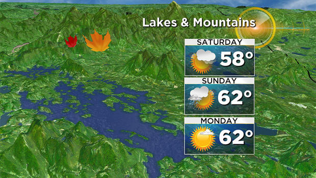
All reports are that this is one of the best foliage years in recent memory up that way, so if you plans are taking you north this weekend, no worries!
As always, we urge that you stay tuned to forecast updates on WBZ-TV, CBSBoston.com and now CBSN Boston!
Follow Terry on Twitter @TerryWBZ