Relief On The Way As Comfortable Weather Moves In
BOSTON (CBS) - The extreme heat and humidity are over! Phew! While no record high temperatures were broken in most of the area, Boston's low temperature of 80 Saturday morning tied the highest low temperature for the date set back in 1977.
Sunday morning, the low temperature was 83, which beat the record of 81 set in 1991. Since Friday, the added factor of near-record-high oppressive humidity made it unbearable for many. It truly was a dangerous situation Saturday when the heat index exceeded 110 degrees at times in places. The goal is to avoid any heat-related illnesses by taking it easy, reducing physical activity, avoiding prolonged exposure to the sunshine and staying well hydrated with water. I hope you endured this wretched weather without any serious impact.
It was Boston's first heat wave of 2019, and the three consecutive days at 90 or higher through this weekend have boosted the total for the year to eight, and all of those days have occurred in July. Of the whopping total of 23 such days that occurred last year, seven of them happened in July, followed by 10 in August. It was a record-breaking hot and humid August. Hopefully, this August will not be so sultry. Looking ahead through this week, relief is on the way with much more comfortable weather. The arrival of the driest air will be preceded by a few rounds of rain and spotty thunderstorms starting just after lunch Monday and winding down by Tuesday afternoon.
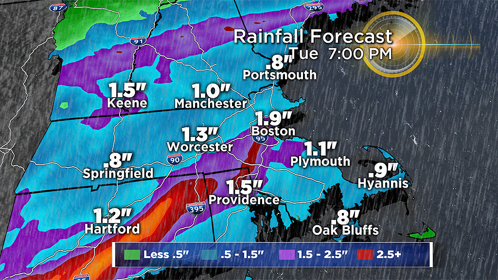
As two or three waves of low pressure pass across the south coast of New England to southeastern Massachusetts, the rounds of rain could amount to 1"-3," with isolated higher amounts primarily focused in an axis northwest of a Providence to Plymouth line. It looks like the tropical downpours will be most robust Monday evening. With that wave, there is a potential for some spotty strong to isolated severe storms happening over southeastern New England. Once the final round shifts offshore by Tuesday afternoon, the driest air will flow in and provide delightful conditions with sunny to partly cloudy weather Wednesday through the weekend. It will turn hotter and muggier over the weekend, but a repeat of extreme heat and humidity is not expected at this time.
We are so fortunate to live in New England where breaks in the steamy weather occur during the summer. Thankfully, we were given a great gift on Thursday when rather cloudy and cool weather preceded this heat wave, and now we get to enjoy another break in the days ahead.
Check our updates here at cbsboston.com and on WBZ-TV.
Have a great week.