How Much Snow Can Boston Expect From What's Left Of Winter?
BOSTON (CBS) - Winter. It is undeniably our longest season of the year. But it comes in all sorts of different flavors. Every autumn, we put our heads together to look at all the indicators on the table and figure out what may come over the following months. As I'm sure you have noticed, this year has proved to be especially challenging! It certainly hasn't been harsh to this point but there's still a solid month on the clock. So let's take a look back at what has happened so far, and what we may receive down the home stretch.
Back in November, we were looking at a few major factors. One being an expected El Nino to develop. Another being some early polar vortex disruption. A warm pool of water south of Alaska. And also the fact that November was trending cold and snowy. November is typically a great bellwether month (when it goes cold, winter heads cold, when it is mild winter is often mild). The way that November was going, we decided to buck the usual El Nino kickoff to the season and go with higher snow and cold chances in December. While it started out cold, it certainly did not last. And when the storm track shifted more favorably for us, there was no cold in sight. What we ended up with was a very typical El Nino December that was milder than average and less snowy than average. Nature threw us a bone with some Christmas Eve snow showers but other than that it was a total snoozefest and definitely our biggest miss of the outlook.
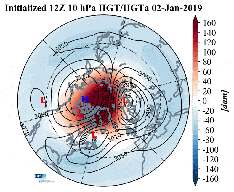
The polar vortex split in two at the start of January, with the main vortex heading toward Siberia and a smaller 'daughter' vortex into Canada
A sudden-stratospheric warming event (SSW) did indeed occur and led to a polar vortex split on January 2nd. But it didn't end up having much of any impact on the eastern U.S. A lot of the cold ended up on the other side of the hemisphere. The MJO (Madden-Julian Oscillation) also spent a lot of time in the warmer phases during January, which helped keep consistent cold away from us in southern New England.
We predicted January to be one of the least harsh months of the winter, and generally speaking this worked out. It was again milder than average, even with a couple of solid 2-3 day cold shots mixed in. Again, there was very little snow with most of the area receiving 2-8" for the month. And the start of February has been one of the warmest on record with, you guessed it, no snow.
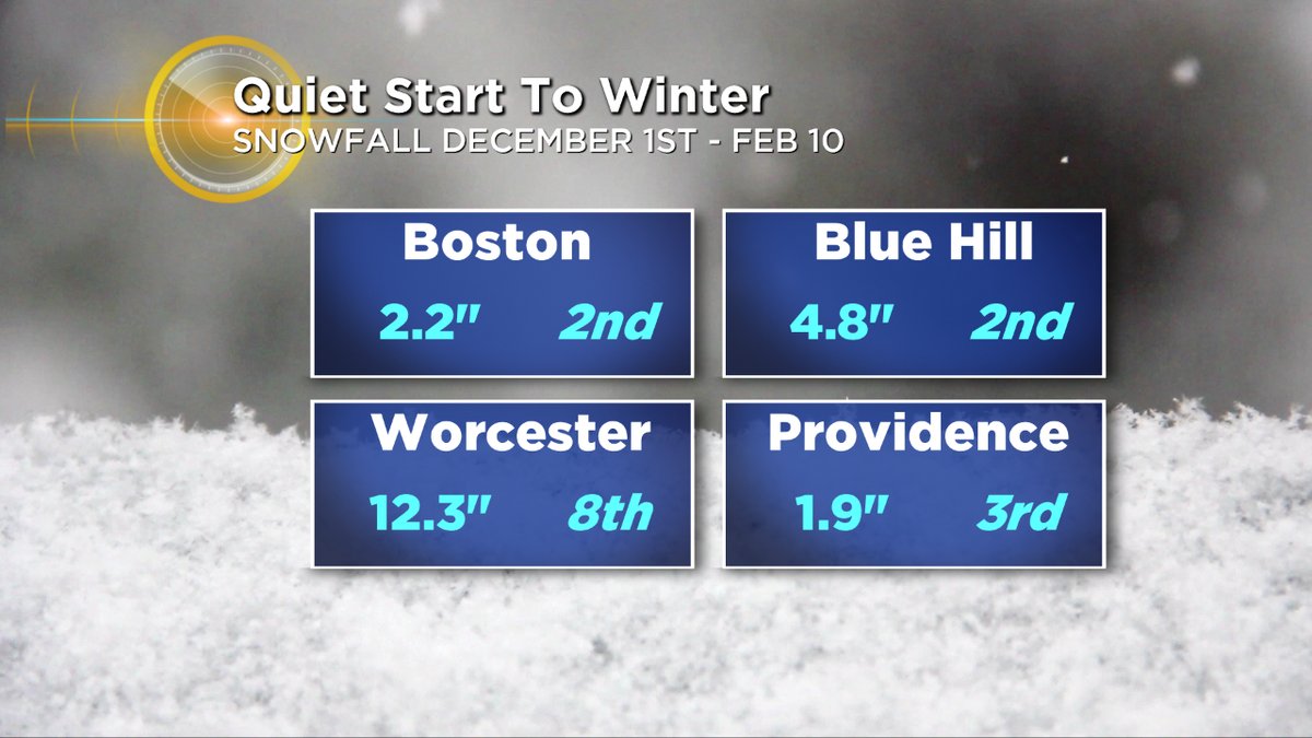
Graphic: WBZ-TV
Overall from December 1st to date, you'd be hard pressed to find a less snowy winter than this one.
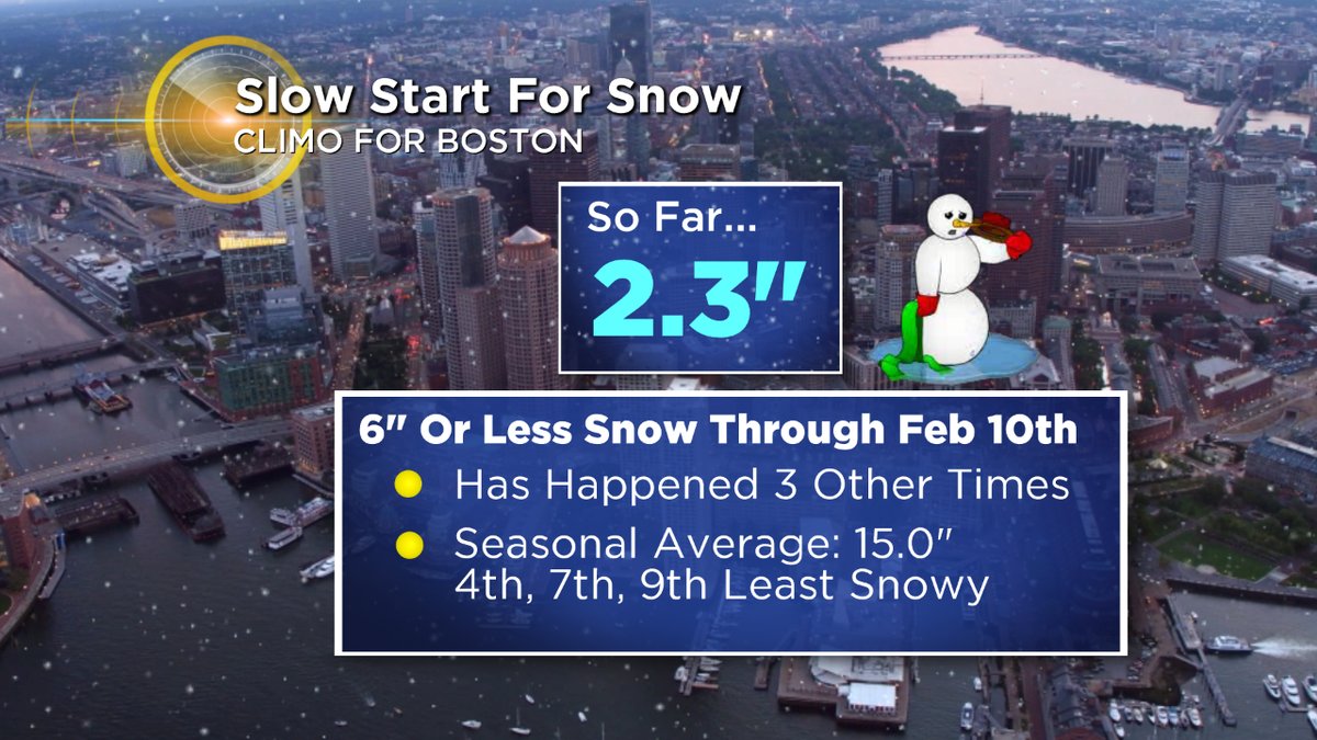
I will say that there is a little caveat to the Boston total. They have been having some observer issues, because anyone in the city will certainly tell you we got about 2" of snow back in mid-November and about 4" in mid-January. The idea is the same (generally snowless winter to date) but the exact numbers do matter when we're close to historical context here. So I've been doing stats for 6" of snow through now. There have only been three other winters with 6" of snow or less through February 11th, and the average snowfall for the whole season among those three is 15". Yikes. They stand as the 4th, 7th, and 9th least snowy winters on record.
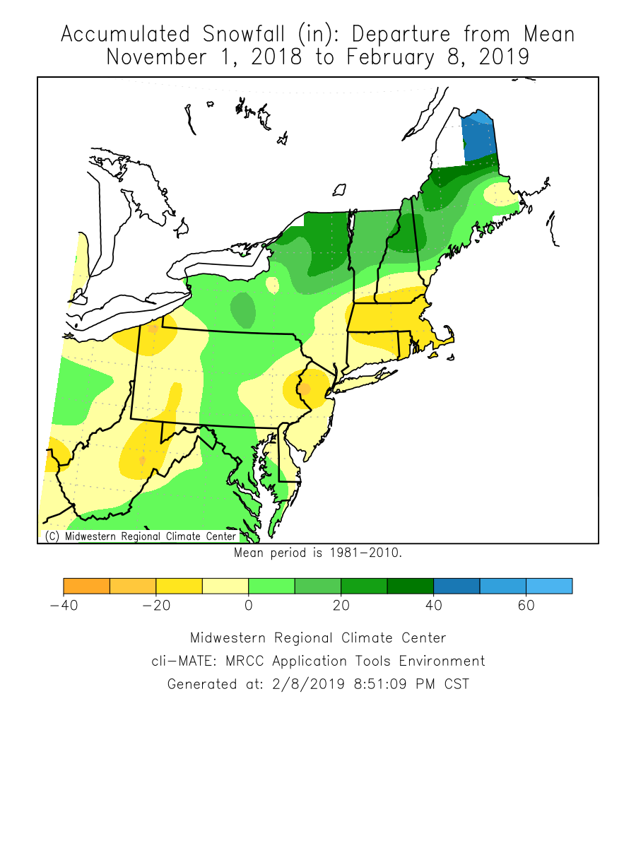
Snowfall anomalies since November 1st. Northern New England a whole different world than southern New England! Source: MRCC
What's been particularly odd about this winter is the dramatic difference just a little to the north or south.
Northern New England has been getting slammed with snowfall and is having one of their snowier winters on record. The mid-Atlantic and D.C. area has been doing pretty well. But nothing has been able to come together for us locally. It may just be that we were due for a clunker. I've found that we get a dud winter every 5-7 years in Boston, like clockwork (the last being in 2012). There are so many possible atmospheric combinations that perhaps it's just time for us to miss out. BUT... we are still in a busy part of the season. So now let's take a look at where we may go from here.
Graphic: WBZ-TV
In general, winters that are so slow through this deep point in the season tend to stay that way.
You could look at the all the years with a foot of snow or less in Boston through February 11th, and you'd find 14 of them (dating to 1891). Only one of them got back to average seasonal snowfall (1958). The other 13 all finished well below average, and include the 1st, 2nd, 3rd, 4th, 7th, 8th, 11th, and 13th least snowy winters on record. This doesn't mean that a huge finish to a slow year can't happen, it just means that it hasn't happened in the past 130 years.
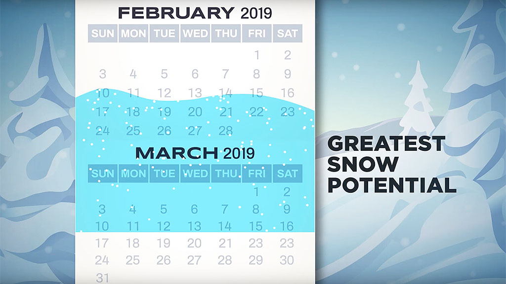
Our outlook called for the majority of our snow chances to come in February and March, and we may indeed see that occur even if we never get to our predicted seasonal total (it would take a near-record run for this time of year to reach it). The next few weeks look to offer quite a few chances for snow and ice and such a pattern will likely linger into early March.
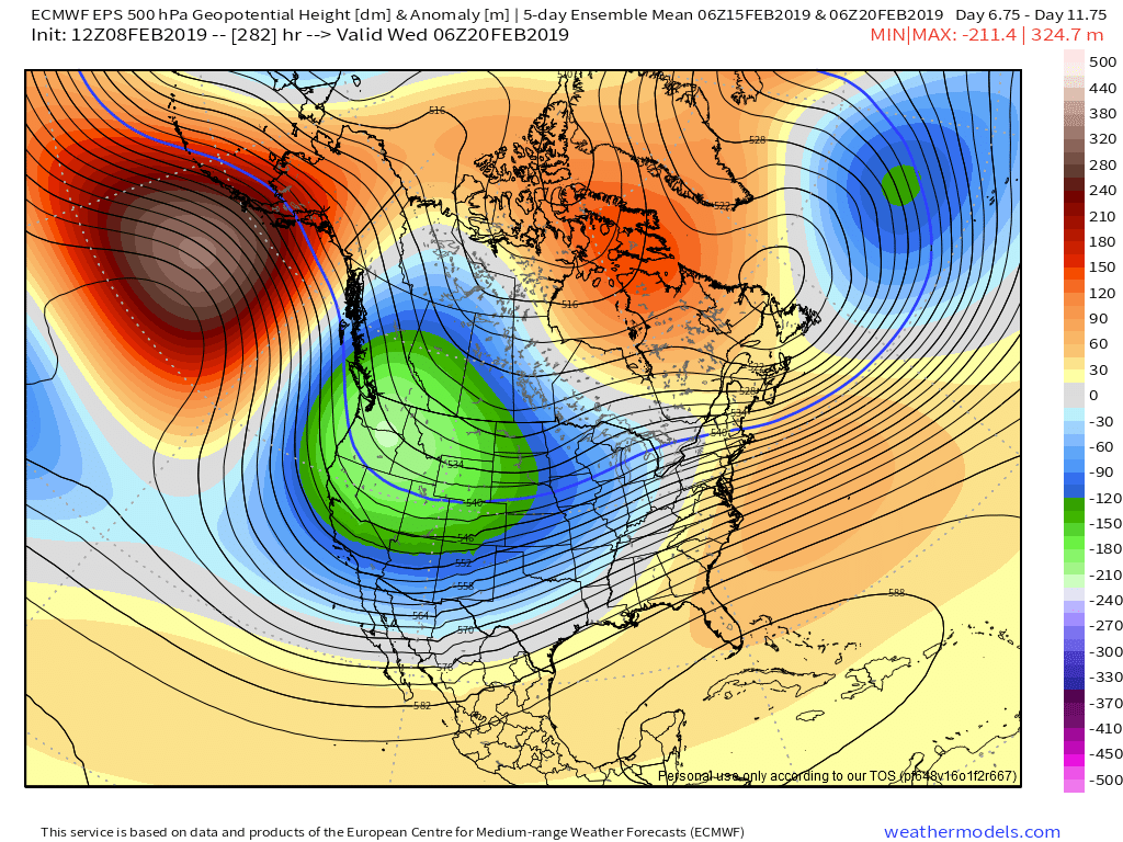
A deep trough across the western U.S. will persist long into February
It's not a classic look to be sure. While El Nino really had an effect on December, its strength has faded all the way back to ENSO neutral conditions. Your typical El Nino progression would be mild in December and then lead to more troughing and snowfall later on in the year. Right now, we are seeing a very stout -PNA, or Pacific-North American pattern. Such a pattern has a deep trough across the western states which does not often favor snowy conditions here. And indeed, the Seattle area and other locales in the Pacific Northwest are expected to stay in an unusually cold and snowy regime for the foreseeable future.
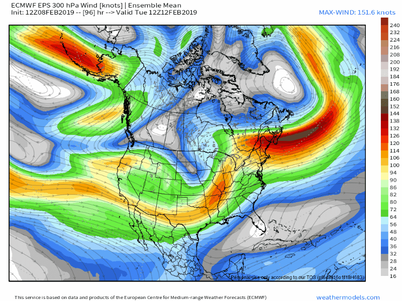
An active jet stream will be pointed right at us for the majority of February
That being said, we have a very active jet stream on tap for the rest of February.
This constant firehose will keep bringing bouts of storms in our direction, many of which could bring snow and ice. Since the jet energy is of tropical Pacific origins, there's mild air in the mix here which makes it a difficult call. This isn't a setup conducive for what we would call 'Miller A' storms that develop in the Gulf and climb the eastern seaboard. These are often our biggest snowstorms and nor'easters. It's a setup that produces a lot of 'Miller B' storms heading into the Great Lakes which then transfer some energy to the coast. That energy transfer helps lock in some surface cold here, a hedge against the mild Pacific invasion. So what I would expect mid-to-late February is a potential barrage of overrunning events and coastal transfers that bring a mix of snow, ice, and rain.
Should this setup prevail as expected, the heavy snows continue to favor northern New England and interior zones, with some snowfall in the coastal plain but not epic snow blitz territory. Without ridging to our west and with little traffic to block up the flow over the Atlantic...you have some cold air to play with in general but you don't have the right steering currents for a series of nor'easter type storms.
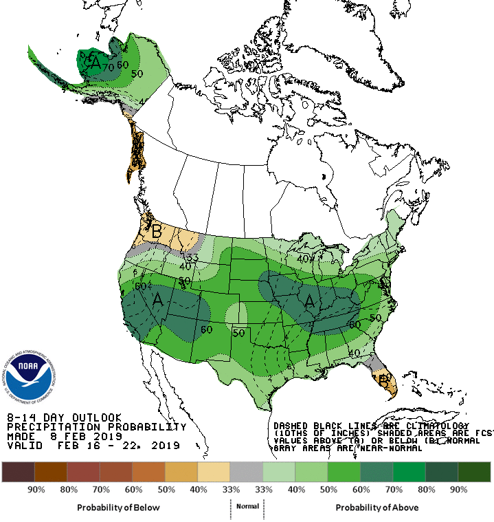
Climate Prediction Center forecasting an active and wet mid to late February across a large swath of the country
We're also keeping an eye on the MJO, which will be favoring colder conditions for us late February into early March. It's expected to travel through phases 8 and 1 at a high amplitude soon, which favors such cold. There is some research out there that says that the exception to this rule is when the polar vortex is in a weakened state, which is an interesting wildcard. In those situations there tends to be more southeast ridging, which would affect storm track for us and also keep the southeastern states warmer than average. If you have a February trip to Florida planned, you're in great shape. It looks to be a very warm month for the sunshine state!
The Madden-Julian Oscillation (which follows storminess/convection in the tropical western Pacific) will be traveling through phases 8 and 1 coming up, which tends to keep the eastern U.S. cold in winter time.
At this point I don't expect us to have a redux of last March, where we got crushed with snowfall and a parade of nor'easters.
There was a very legitimate reason for that pattern, which was the polar vortex disruption in mid-February. The trickle down effects of that disruption stayed with us through early April and just made for a miserable start to spring. This year, we had a much earlier polar vortex split and while we are still seeing some of those downwelling effects from the stratosphere down through the troposphere, those effects will likely run out of gas by early to mid-March at the latest. There is also a solid concentration of sea ice and cooler than average waters around Greenland and Iceland, which tends to favor more +NAO. It doesn't stop -NAO instances from occurring, but the preferred base state might fight against it.
After all the technical stuff, what are the main takeaways?
I think our coldest temperatures are behind us. It will be tough to go subzero, particularly for a couple days in a row, given this pattern. Stormy with an active Pacific for the next couple of weeks at least, and then we're almost to March where climatology doesn't favor air that cold. But the majority of our seasonal snowfall is likely ahead of us.
I don't think Boston will get to 55" per our earlier thoughts in November, but something closer to 12-24" is doable and on the high end up to 40" is probably the limit of what we can pull off over the next month and a half. I would be surprised if we went on a huge anomalous run.
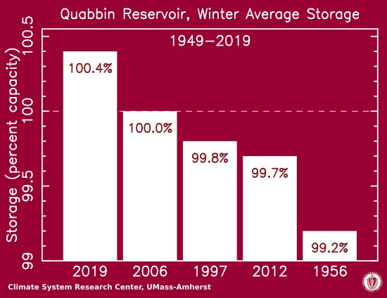
Quabbin Reservoir storage is at a record level for this time of year. Courtesy Michael Rawlins, UMASS Amherst
Aside from snow, our bigger concern is spring flooding, of which we might actually have to deal with for the first time in years.
The Quabbin Reservoir saw its highest winter storage since being build in the 1940's and is over 100-percent. The pattern favors more stormy weather and lots of moisture through the rest of February. And northern New England is covered in snow with more on the way. There's just a ton of water in the ground and unless the faucet completely turns off in spring, it will be a tough issue to avoid. It's also not a great look for spring sports, especially in March. Dry ballfields are going to be tough to find.