Snow Could Make Tuesday Afternoon Commute Treacherous
BOSTON (CBS) – A storm that is churning across the west coast will redevelop just east of the Rockies Monday, gather Gulf Of Mexico moisture and actually produce treacherous traveling conditions for the commute here in New England on Tuesday afternoon and evening! Road conditions should improve by the Wednesday morning commute as this storm will be pulling away from the area.
The primary storm will track across the eastern Great Lakes and weaken as its energy is transferred to a spin-off storm forming near the Mid-Atlantic States. Similar to its predecessors, this coastal-hugging storm will introduce milder air from the ocean resulting in another potpourri of precipitation over southern New England with mainly snow north of southern New Hampshire. Initially, all areas including Cape Cod will get a thumping of snow of varying lengths.
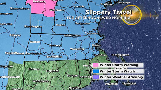
Highest impacts and most likely higher snow totals will be across northern MA into NH and VT where Winter Storm Watches have been issued for Tuesday afternoon through Wednesday morning.
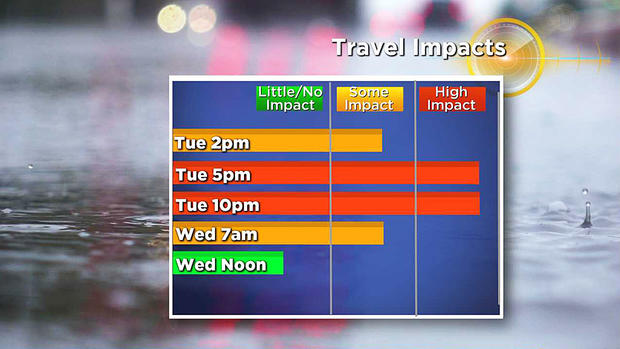
TIMELINE:
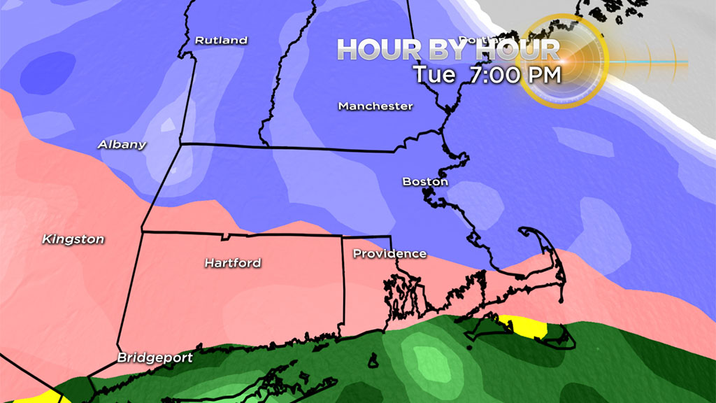
The blue-shaded zones indicate snow, the pink ones indicate sleet and freezing rain and the greens/yellows/oranges represent plain rain.
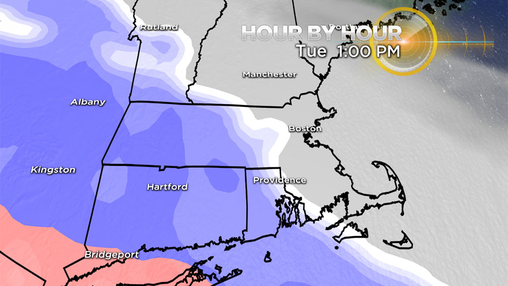
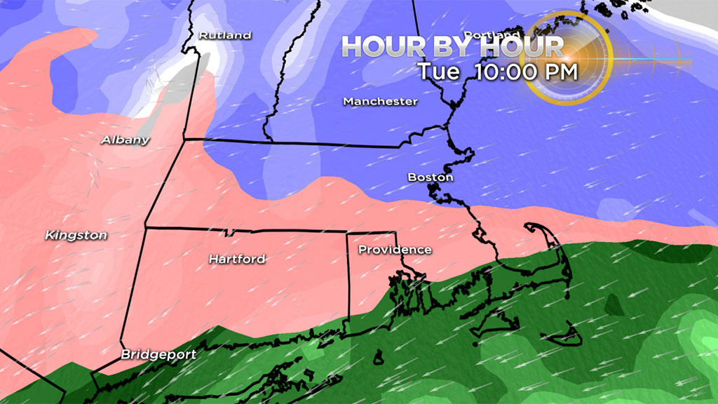
You can see that the swath of snow proceeds eastward across the state on Tuesday arriving in the Boston area around 1-to-2 p.m. The tempo of the snow will ramp up leading into the commute home as the mixing zone gradually pivots northward into the evening. The worst of the travel will be during this first thump of snow with snowfall rates of 1-2" an hour in spots and limited visibility. Roads will quickly become snow covered and slippery during the evening commute.
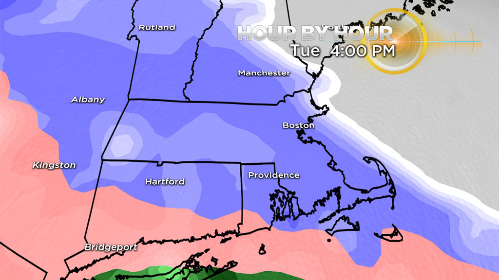
Snow will transition to some sleet and rain from southeastern Mass. northwestward into the Boston area and gradually into the western suburbs to eastern Worcester County.
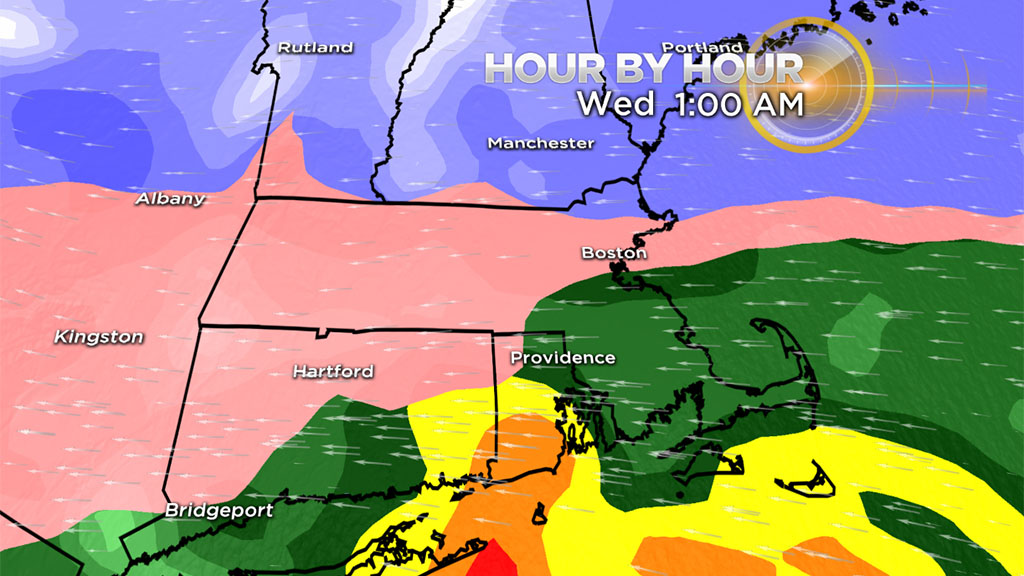
The heaviest precipitation will exit late evening into the early morning hours as colder air wrapping around the storm changes the precipitation back to a bit of snow west of the I-95 corridor.
SNOWFALL:
All locations including Cape Cod and the islands will receive a thumping of snow on the front end. As per usual, the length of that period of snow will be shortest on the Cape and longer farther and farther northwest of Boston. Since it is close to 48 hours away from the start of this event, the snowfall map will likely be tweaked in the next 24 hours or so as the clarity of the changing atmospheric thermal profile improves.
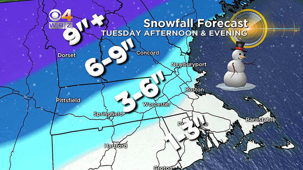
The most reasonable forecast at this time is for around 3 inches or so in Boston closer to the coast ranging up to 4-to-5 inches in Worcester before the phase changes occur. The 6 inch+ line exists from western Mass. to northwestern Worcester County to southeastern N.H. There is the potential for sleet mixing in sooner which would cut down the amounts a bit. If the precipitation remains snow longer (meaning that warm air is slower to arrive), then totals could exceed 6" in many communities northwest of 495.
WIND:
The wind will be freshening and may increase to gale force Tuesday night into Wednesday morning as the center of strengthening secondary storm churns up over southeastern Connecticut to northern Rhode Island and close to or just south of Boston.
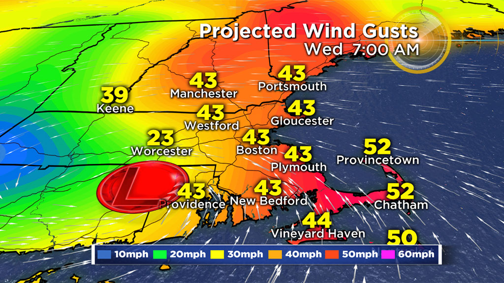
It will blow from the northeast and east but south of the storm track. It will become strong southeast to southerly for a time early Wednesday over southeastern Mass. and the New England south coast. As the system tracks over the Gulf of Maine, the gusty wind on the back side will be blowing from the west everywhere Wednesday afternoon.
REVIEW & PREVIEW:
So what's going on with this winter? Above average snowfall was forecast in our outlook last November!

Are we in for another back-loaded winter again or is spring just around the corner this time? Join us for our weather team thoughts on WBZ-TV News At 5 p.m. Monday.