Heavy Rain On The Way And Wet Snow Possible Up North
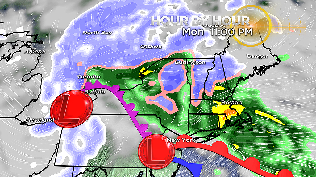
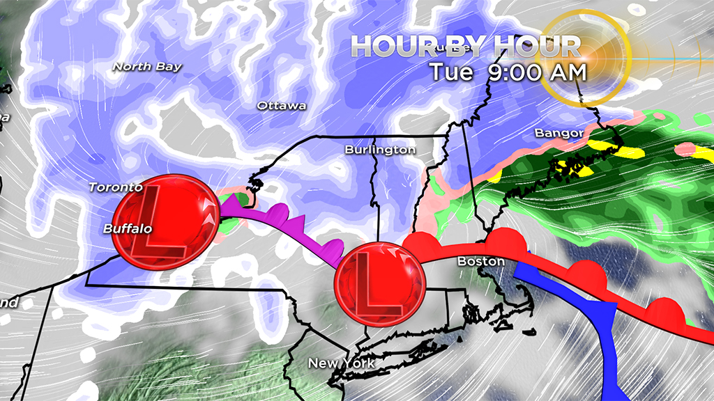
BOSTON (CBS) — Here we go again - the unsettled pattern continues as everyone heads back to work and school after the holiday. That's if you made it back from travel. A potent storm in the Midwest grounded flights from Chicago to Boston over the weekend. That storm continues to deliver blizzard conditions in the Midwest and Great Lakes and eventually will transfer some of its energy to a developing low pressure system off the Mid-Atlantic that will head into New England later Monday.
Let's get to it.
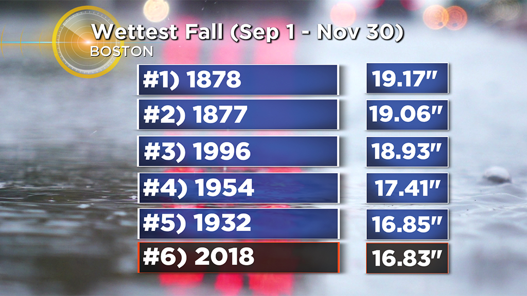
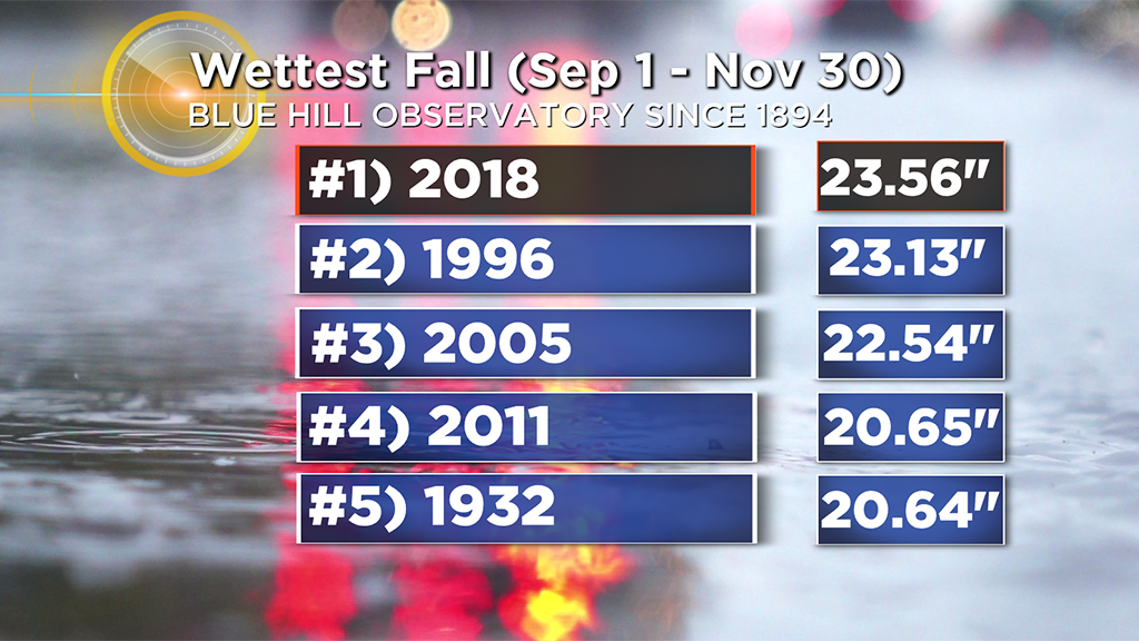
After another weekend of rain, more rain is expected Monday night. Boston is closing in on one of the wettest falls on record, while Blue Hill Observatory has taken the number 1 spot!
Areas of fog/mist greeted many as they went outside Monday morning. Temperatures will range in the mid 30's in central Mass. to the low 40's across eastern areas. As easterly winds develop, clouds will be tough to break today with pockets of drizzle or a shower possible. Steadier rain arrives by the late afternoon and evening commute from west to east.
Rain will be heavy at times overnight before tapering to showers and drizzle Tuesday morning. Gusty downpours will lower visibility and make travel difficult from 7 p.m. Monday through 4 a.m. Tuesday.
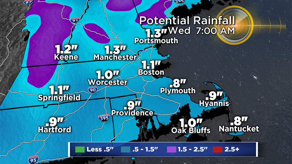
Rainfall amounts will range from 0.5 inch to 1.5 inches in spots. Be aware of nuisance poor drainage and street flooding tonight through early Tuesday. Localized minor river/stream flooding is also possible across eastern Mass. and R.I. into midweek.
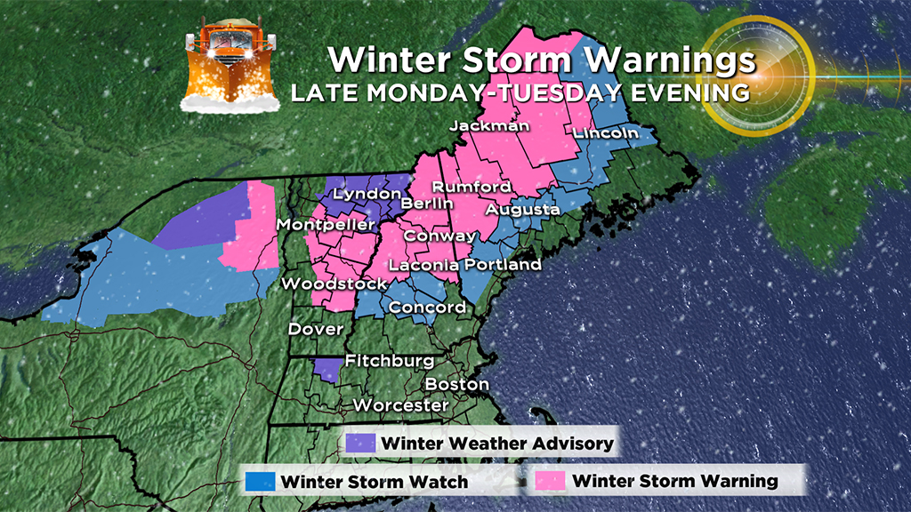
While most of the precipitation will be rain, there could be some wet snow over parts of northern Mass. especially north central to northwestern parts of the state northward with another bonanza of snow over the northern mountains. I expect some areas to receive more than a foot of snow. The higher elevations are at a greater risk. Some minor snow accumulations are possible across the northern Worcester Hills into western Mass. A few inches are possible over far northwest Mass., with some freezing rain creating slippery travel through Tuesday morning.
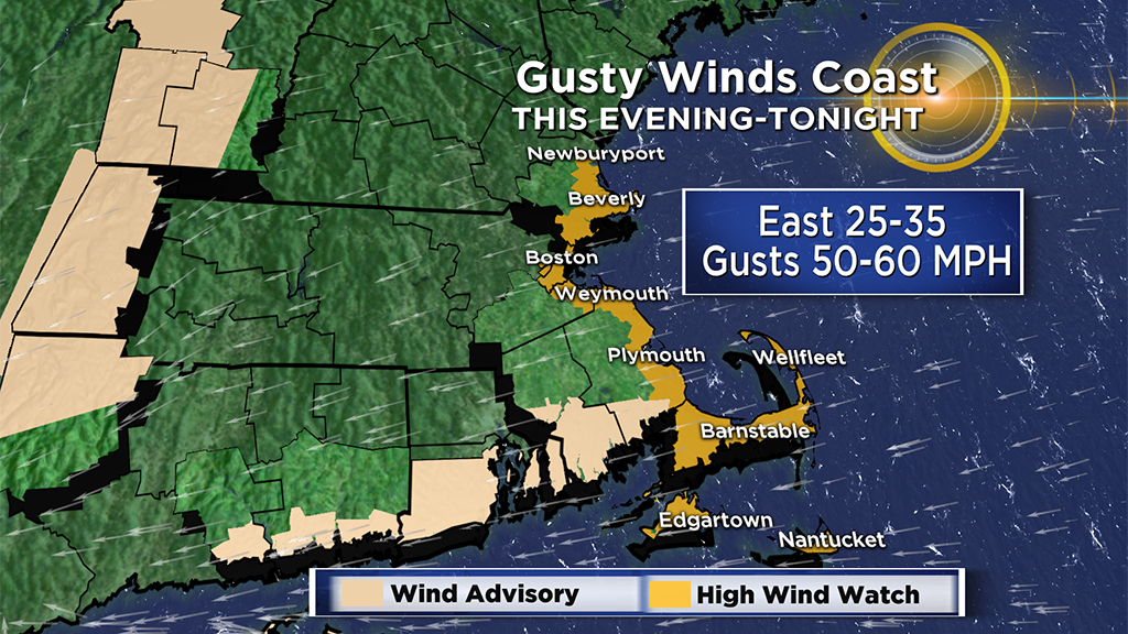
Easterly winds will increase through the day with gusts 20 to 30 mph by the evening. East winds 15-30 mph with gusts 40-60 mph are possible along the coast which may lead to downed branches/trees and isolated power outages. A wind advisory is in effect from 9 p.m. Monday through 4 a.m. Tuesday for the south coast. A high wind watch is in effect from 9 p.m. Monday through 4 a.m. Tuesday for the eastern coast of Mass., including the Cape and Islands.
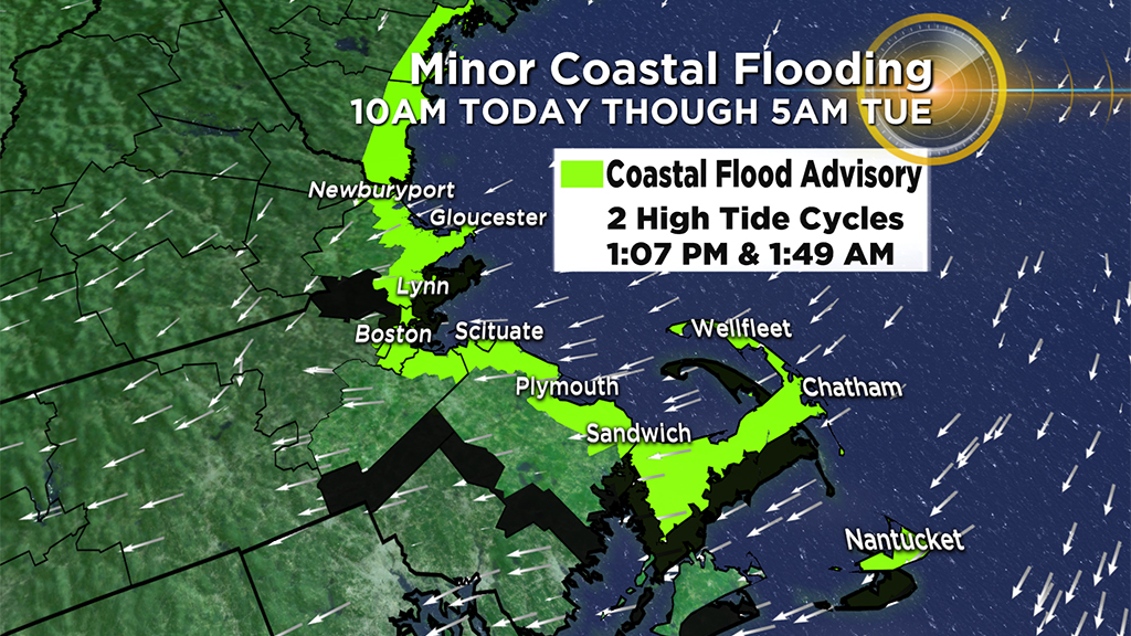
A gusty onshore fetch will increase the threat for minor coastal flooding during the midday high tide and again during the overnight high tide. A coastal flood advisory is in effect from 10 a.m. Monday until 5 a.m. Tuesday for the eastern coastline of Mass. including Nantucket. There may be some typical shoreline roads that flood and become impassable for a time before and after high tide. Those strong easterly winds will also build seas to 15-20 feet offshore creating hazardous conditions for mariners.
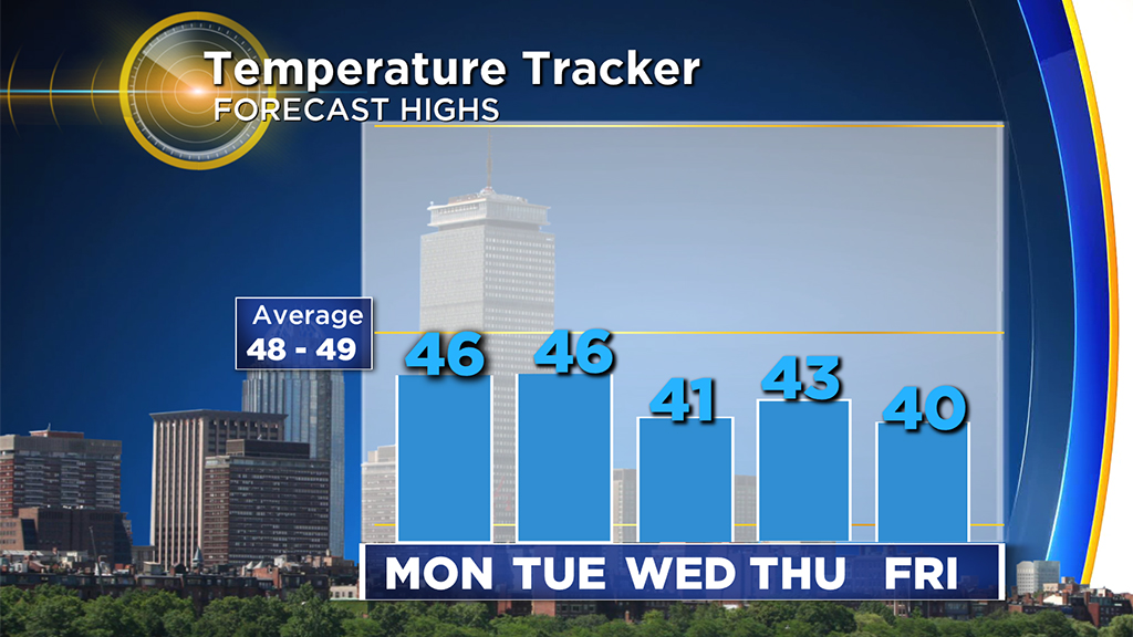
We'll see some slow improvement on Tuesday as the storm continues to lift northward, but can't rule out a stray shower and breezy west winds. Highs will range from the upper 30's in central Mass. to the upper 40's over southeastern areas. A cold pocket of air will linger over New England on Wednesday, stirring up clouds capable of producing a few snow showers. Highs will be near 40.
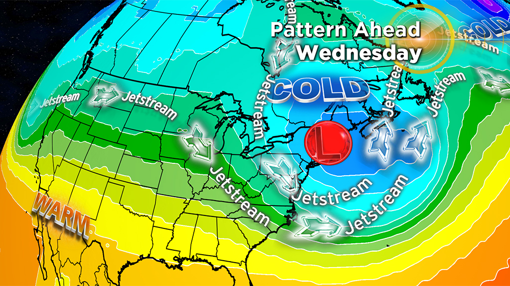
After some scattered snow showers across the region on Wednesday, it should be storm-free and sunnier with below average temperatures but not frigid the second half of this week.