Snow Could Be An Issue Tuesday Morning, Thanksgiving Will Be Frigid
BOSTON (CBS) - Get ready for a one-two punch of wintry weather before a frigid Thanksgiving!
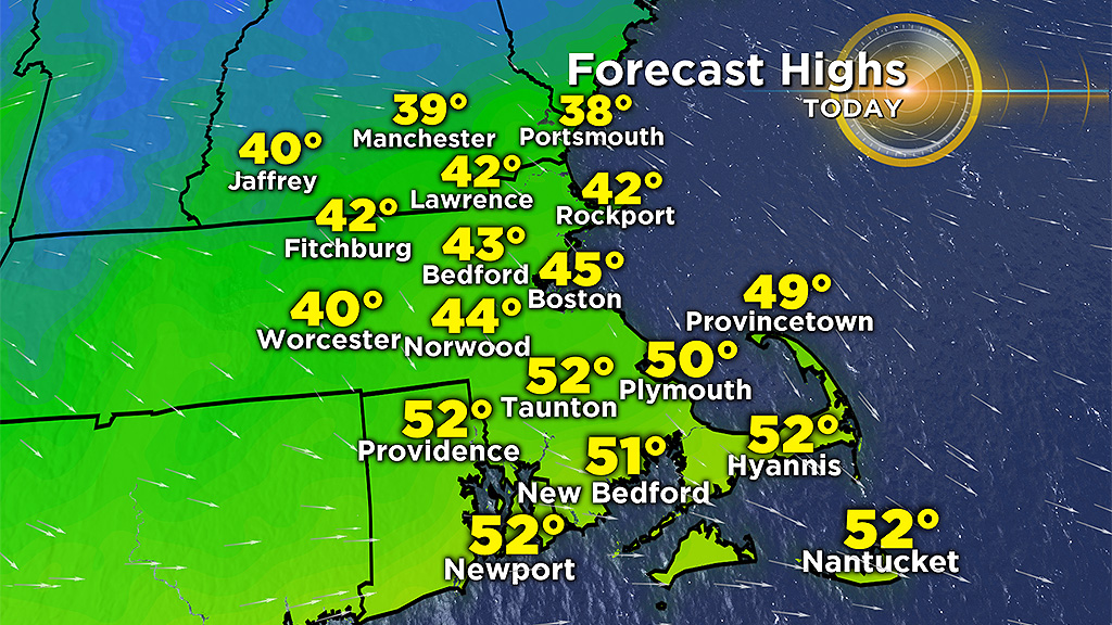
Several towns had some snow, freezing rain and rain overnight. Temperatures will rise Monday allowing for a transition to rain by mid-morning. Precipitation will taper by midday with drier conditions in the afternoon. Highs will range from the 30's to mid-40's north and west of the Boston, to upper 40s and low 50s over southeastern Massachusetts.
The evening commute will be dry, but another round of rain and snow moves in between 8 and 10 p.m. from west to east. Temperatures will support snow mainly north and west of I-95 and north of the Massachusetts Turnpike, with scattered rain south.
I expect more delays and travel problems for the Tuesday morning commute as a burst of heavy snow may reduce visibility and quickly coat the roadways.
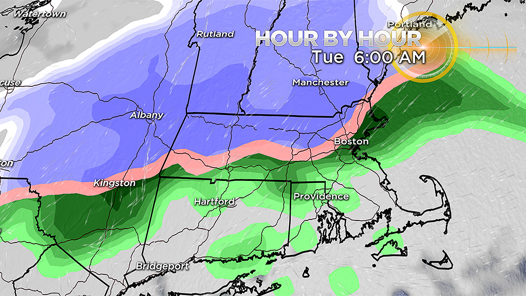
The heaviest snow and rain will fall from 5 to 10 a.m. Heavy rain can also drag down cooler air, meaning there may be some mixing in and around Route 128. Low pressure will pass near and over Cape Cod by the afternoon, allowing for parts of eastern Mass. even the Boston area to flip over to snow as the system moves out.

Scattered snow and rain showers will linger for the evening drive, but move out by 8 to 9 p.m.
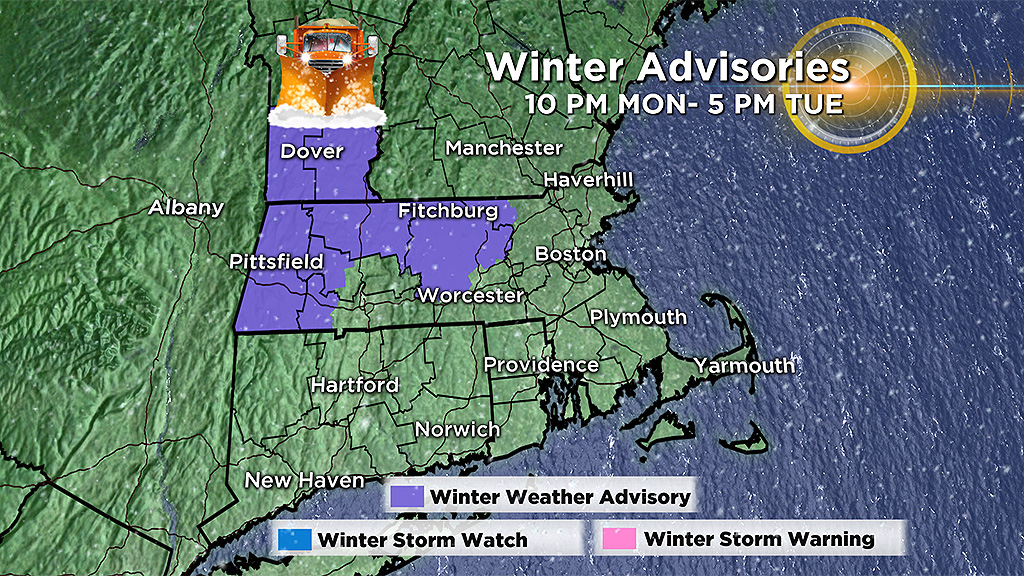
A winter weather advisory will be in place for central and western Mass. starting at 10 p.m. Monday through 5 p.m. Tuesday for expected slippery travel conditions.
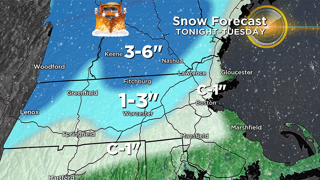
We are expecting a slushy coating to 1 inch of snow for areas inside 128 and south of the Pike. It will also be a slushy accumulation near 128 to 495 for the snow to rain to snow flip/flop with 1-to-3 inches possible. Best bet of the higher totals is where it will stay all snow during the event, like the higher terrain of north-central Mass. into New Hampshire and over the Berkshires where 3-to-6 inches is possible.
We dry out on Wednesday, but don't see much improvement in temperatures. The normal high this time of year is around 50 degrees, and 30's are likely on Wednesday before even colder weather arrives for Thanksgiving. At least travel should not be a problem, although as arctic air pours in late Wednesday a few scattered snow squalls may limit visibility for a time for drivers.
Thanksgiving will be dry and bright, but it will be COLD.
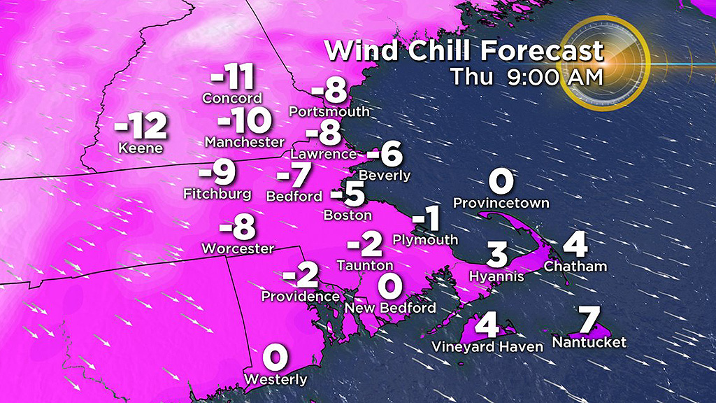
Check out the blog from Barry Burbank about how we could be breaking a 100-year-old record for the date and waking up to subzero wind chills on Turkey day!