Large Storm To Bring Plenty Of Rain Saturday And Maybe Snow In Spots
BOSTON (CBS) - Coastal storm season has arrived. Wait what? It's only October you say? Too early for Nor'easters, snowfall and coastal flood threats? How quickly you forget!
Let me refresh your memory with just a few major storms in late October in recent years.
October 29-30, 2017: Bombogenesis! Flooding rainfall, wind gusts over 70 mph. numerous trees down and power outages for several days in some areas.
October 29, 2012: Hurricane Sandy makes landfall in New Jersey. Halloween postponed or cancelled in many parts of New England and the Northeast due to intense flooding and prolonged power outages.
October 29-30, 2011: Snowtober! Halloween postponed or cancelled again for a good portion of southern New England. Some areas inland received over 2 feet of heavy, wet snow, thousands of downed trees and more than a million homes and business left without power for days or even weeks.
And that's not all. Some of you may remember the Perfect Storm back in 1991?
Well, here we go again. While we are not currently forecasting anything quite as destructive as the events listed above, it does appear as though a sizable coastal storm will form and affect us this weekend, once again, just days before Halloween.
This one is actually rooted in the Pacific Ocean right now. Perhaps you have heard of Hurricane Willa? Willa is set to make landfall as a Category 2 hurricane just north of Puerto Vallarta Tuesday evening. It will quickly dissipate as it moves into interior Mexico, however, some of the energy associated with the remnants of Willa will emerge in the Gulf of Mexico in the coming days. That energy will combine with a digging storm in the central part of the country and form a coastal storm off the Carolinas by late Friday. Grabbing some extra fuel from the Gulf Stream, the storm will intensify as it heads north, up the East Coast, bringing heavy rain, strong winds and even some SNOW. (more on that in a minute)
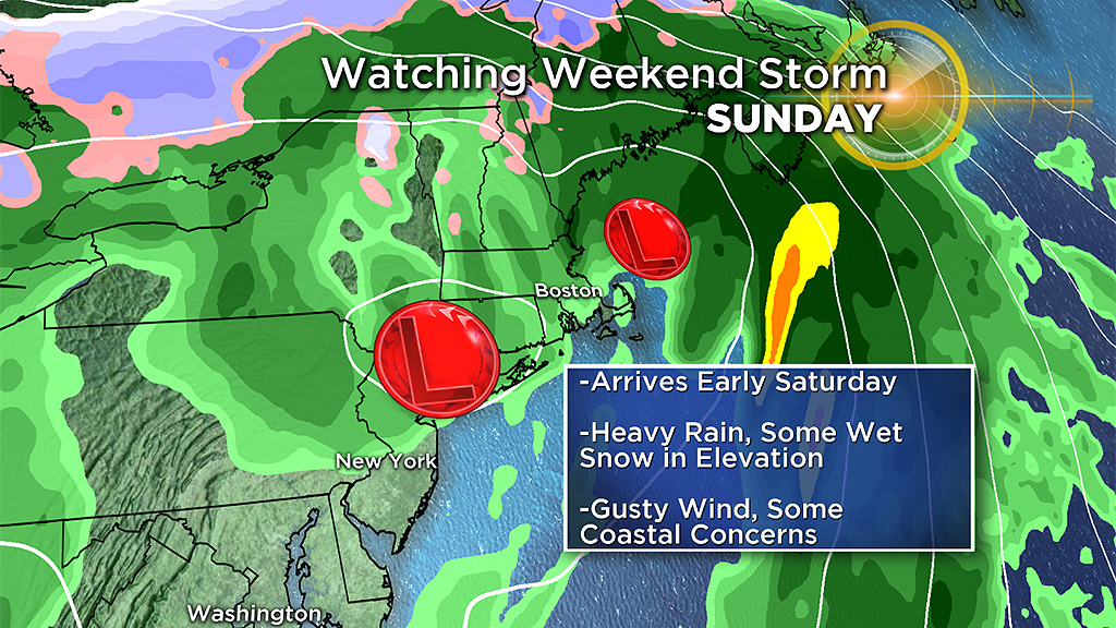
So what can we expect here in southern New England? Keep in mind that as of this writing (on Tuesday) there is still a long ways to go before this storm comes together. Things will change!
TIMELINE:
Precipitation arrives Saturday, but there's still some question as to whether it gets wet as early as Saturday morning or if we can sneak in at least a partially dry day. At this point, odds favor rain arriving by mid-to-late morning (from south to north). Heaviest precipitation will fall Saturday PM and overnight, likely tapering off by Sunday morning.
PRECIPITATION, RAIN v SNOW:
Believe it or not, there is enough cold air around late Friday and early Saturday for this to be a fairly close call between rain and snow. Right now it appears the areas with the best chance of receiving some wet snow accumulation would be elevated locations such as the Berkshires, the Green and White Mountains and possible even the Worcester Hills. While we cannot rule out some snow closer to the coastal plain, as of now the odds of that are low.
HOW MUCH:
Rainfall amounts could easily top an inch with this storm, perhaps reaching 2 or 3 inches in spots. Not enough to cause any significant or widespread inland flooding, but some urban/small stream flooding cannot be ruled out.
Snow amounts are still a bit in question. However, a coating to a few inches of heavy, wet snow cannot be ruled out in the northernmost elevated parts of Worcester County. Odds are even better of a few inches in parts of the Berkshires, Green Mountains and White Mountains.
WIND:
Gusty east-northeast winds are likely on Saturday, especially close to the coast. Gusts may reach 25-50 mph along the immediate coastline and over Cape Cod and the Islands. We will refine these forecast numbers as we get closer to the storm later this week. Some wind damage is possible, perhaps exacerbated by the fact that the trees are still fully foliated.
COASTAL FLOODING:
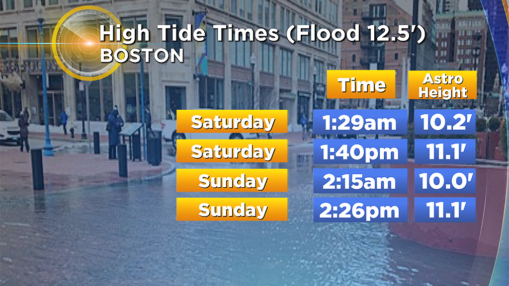
Unfortunately the storm is arriving just after the full moon so tides will be running high astronomically. Some minor splash over and coastal flooding is possible around the times of high tide on Saturday ( 1:40 p.m. in Boston) and early Sunday ( 2:15 a.m. in Boston).
Again, we are still several days away from any impact. As always, we urge that you stay tuned to updated forecasts this week on WBZ-TV and CBSBoston.com.