Hurricane Florence Expected To Make Direct Hit In Carolinas Thursday Into Friday
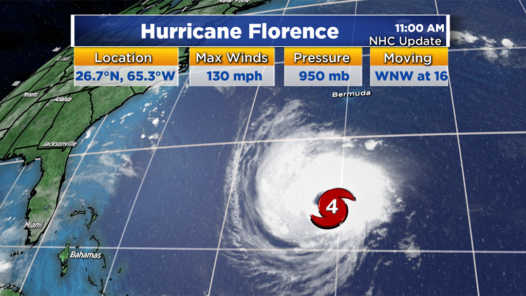
BOSTON (CBS) - Another day closer to landfall and unfortunately no significant changes in the forecast for Hurricane Florence. As of midday on Tuesday, Florence remains a powerful category 4 hurricane with maximum sustained winds of 130 mph. It is passing several hundred miles south of Bermuda (now less than 1,000 miles from coastal North Carolina) and appears to be headed for an eventual landfall in southern sections of North Carolina later this week.
Hurricane Florence: Tracking Maps and Computer Models
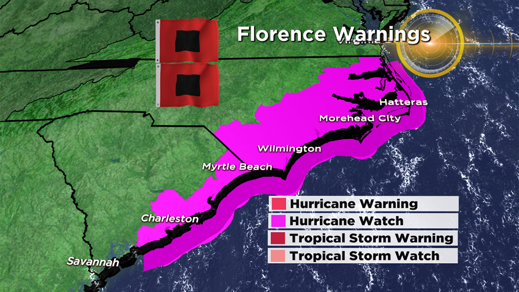
Many coastal residents in North and South Carolina have already evacuated. If you have family or friends in that area, please urge them to heed all warnings and evacuation orders and continue to stay tuned to hourly update from reputable sources.
TIMELINE
Tropical storm force winds (39 mph+) and the first outer rain bands will arrive along the North Carolina coast Thursday morning. The wind and rain will continue to ramp up during the day Thursday with hurricane force gusts (74 mph+) arriving Thursday evening. The most powerful winds will arrive overnight Thursday and throughout the day on Friday.
Many areas, particularly focused along the North Carolina coastline, could see frequent gusts well over 100 mph with sustained winds near 100 mph as Florence slowly moves ashore. Once Florence pushes over land, the winds will rapidly decrease below hurricane force by Friday night and below tropical storm force over the weekend. The rain will continue for several days, centered over the Carolinas and Virginias. Many locations will measure the rain in feet. The remnants of Florence and the rain will likely not be completed kicked out until sometime early next week.
MAIN IMPACTS
The first significant impact will be from the hurricane force winds. The wind damage from a category 3 or 4 hurricane is catastrophic. Coastal areas are at greatest risk of seeing sustained winds to 100+mph and gusts well above that. Again, the wind threat is focused mainly from Thursday night through Friday.
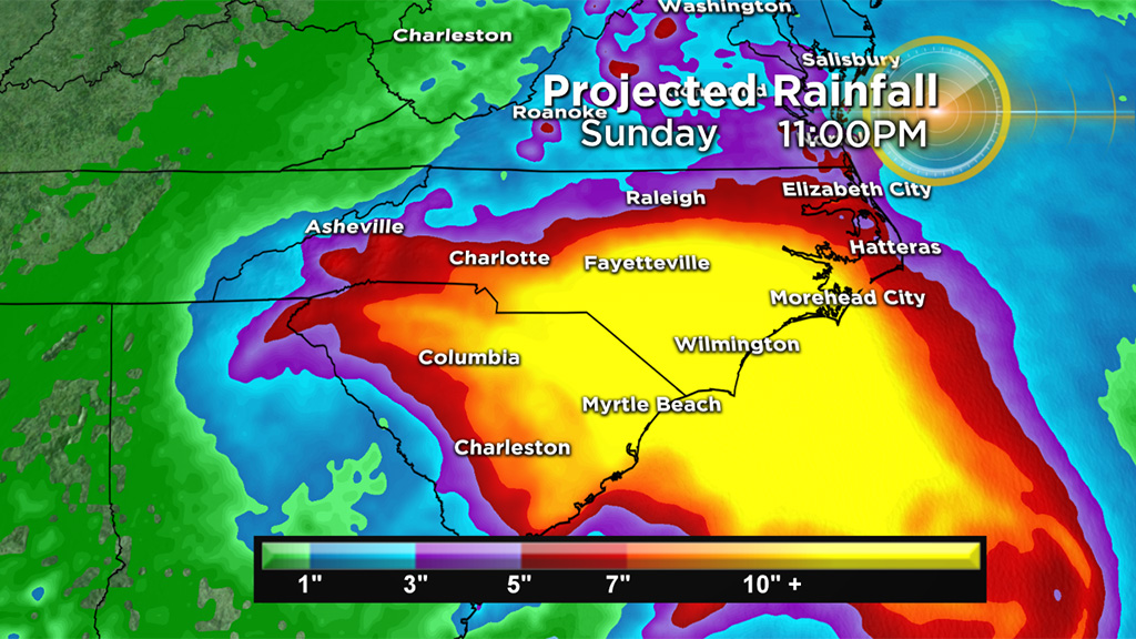
Life-threatening and catastrophic river and flash flooding is also a near certainty for the Carolinas. With 1-to-3 feet of rainfall expected in some areas, significant river flooding will occur.
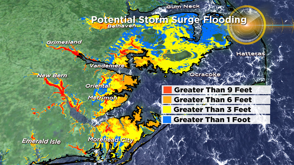
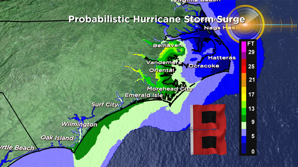
A life-threatening storm surge is forecast in portions of South Carolina, North Carolina and Virginia. Current estimates are as high as 10-to-20 feet of surge in coastal North Carolina (west of the Outer Banks). This could lead to massive flooding in many of North Carolina's inlets. Some models are predicting more than 9 feet of water to pile up on the western end of those waterways.
Last but not least, large ocean swells will threaten mariners in that region and for a large portion of the East Coast. Wave heights just offshore of the Carolinas will reach 20-to-40 feet or higher. Those swells will propagate outward from the center of the storm, leading to potentially life-threatening surf and rip currents as far north as New England.
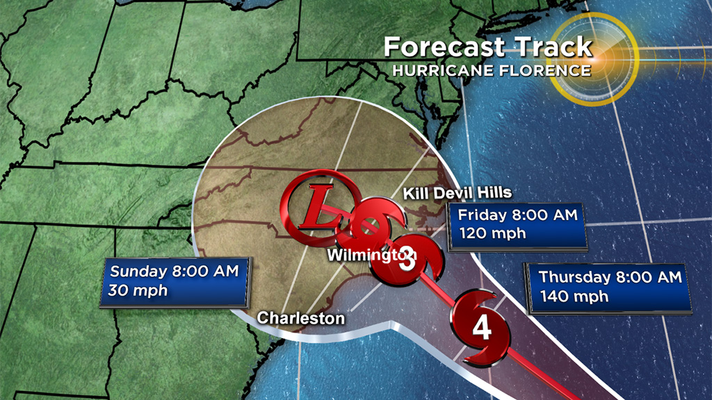
There is no out to sea solution. All models are now pointing to a direct hit from Florence in the Carolinas. This will likely be one of the strongest hurricanes ever to make landfall on the East Coast north of Florida. In the middle of what has been a very quiet season in the tropics, Florence is proof that it only takes one.