Hottest Stretch Of The Year Heading Into New England
Find Eric Fisher on Twitter and Facebook
"You don't shovel humidity"
Keep this old summer standby in mind as we head into what will handily be the hottest stretch of the year so far. While we may not set many records during it, a prolonged stretch of heat and rising humidity will put is in midsummer form just in time for the 4th of July holiday. If you took the week for a beach vacation, you chose quite wisely my friend. I will salute you from my windowless but thankfully air conditioned weather center.
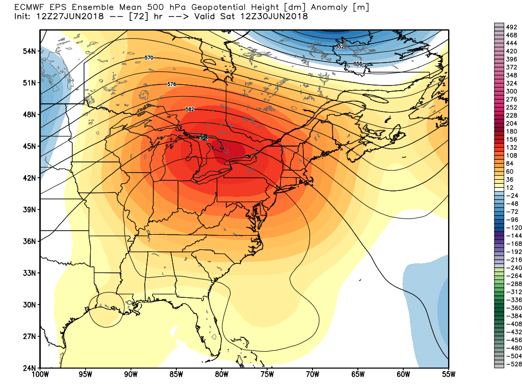
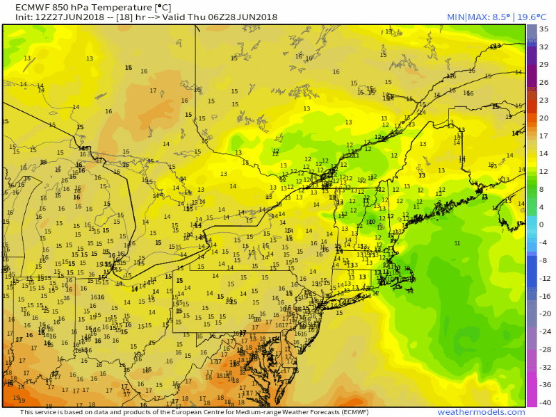
Here's the big picture. A ridge rapidly builds into the northeast this weekend, allowing a very warm air mass to head eastward from the Plains. Aloft (a few thousand feet up) air temperatures will rise to about +22C! That's hot stuff, and some guidance has even sniffed around +25C air spots. That's all well and good if you're on a mountaintop, but what does it mean for us near sea level? It all comes down to wind direction. In theory, an air mass like this can produce temps in excess of 100F at the surface. BUT, there's a catch. It's not easy to hit 100 degrees around here, especially in Boston since it is right on the water. We've only had 15 days reach 100 degrees since record keeping moved to Logan Airport in 1936 (the last one coming in 2011). So what do we need to reach that lofty mark? A west or west-southwest wind. This direction allows that warm air aloft to mix down, keeps any ocean influence at bay, and features some downsloping off the Worcester hills. We don't have it this weekend. So I don't think we have a shot at 100F at the official Boston observation site.
That being said, what we do have is a south-southwest wind. This direction should place the peak temperatures across northern Massachusetts, New Hampshire, and Vermont this weekend. particularly on Sunday and Monday. So if we hit the century mark, those are the places I would watch for. In addition, we may be able to nab it in the CT Valley around Bradley Airport. All of this is semantics - it's going to be plenty hot for all of us.
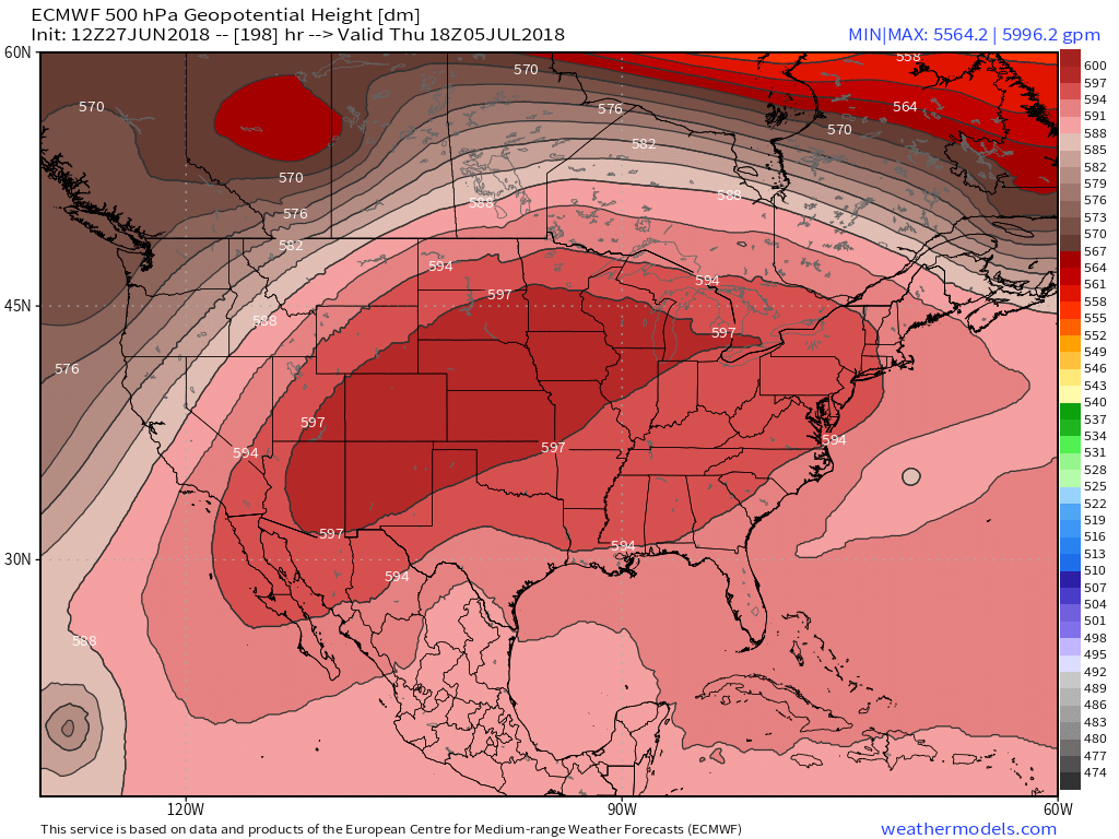
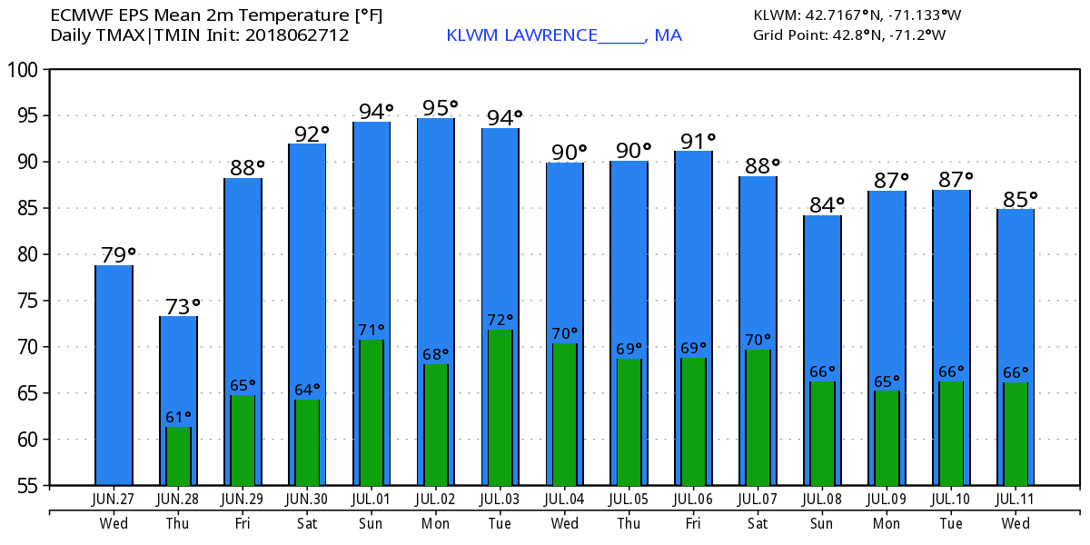
This ridge becomes extremely expansive next week and will make for a sizzling 4th of July holiday for nearly all of the Lower 48 outside of the Pacific Northwest. The worst of the heat will back down a touch here while this ridge expands west, but there's a chance inland areas (outside of I-95) may see an 8-9 day heat wave with every day reaching 90 degrees or hotter! While 90s are not unusual, that many in a row would be.
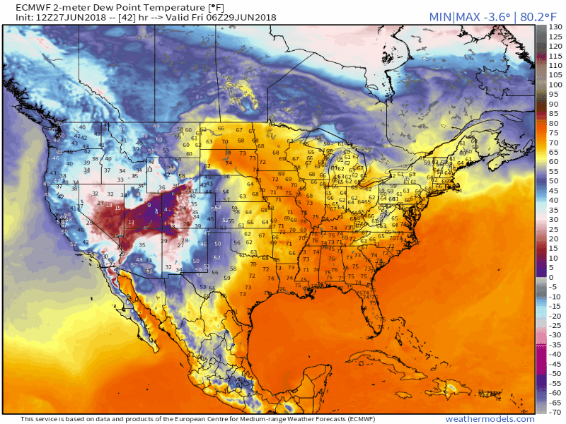
The other big feature of this pattern will be humidity. We've barely had to use air conditioners so far this year as the humid days have been few and far between. Little 1-2 day spikes is all we've had to deal with, and there have been quite a few unusually dry/cool nights. Real comfortable stuff. That is coming to an end. Lots of humidity will keep overnight lows up and over time that can get pretty nasty for those who do not have the luxury of AC.
Let's dig into the daily details:
Friday - The stretch begins
A front will be moving offshore Friday morning bringing in sunshine and slightly less humid air. Dewpoints will still be in the upper 50s to mid 60s most of the day, so mugginess will linger and the strong late June sun should bring highs close to 90 for many areas with 80s for highs along the coast. Overall, a great beach day! The towns that manage to hit 90F will start their heat wave.
Saturday - Hot, but typical midsummer heat
On Saturday our ridge will be building in, but we may still have some high cirrus clouds to veil the sunshine a bit before it can gain firm control of the region. As the hot air moves in aloft, we should be able to see highs reach the low 90s away from the coastline. A weak pressure gradient should let sea breezes develop, with coastal highs in the mid 70s to low 80s. A very good opportunity to head to the beach, and dewpoints won't be oppressive yet. Generally we'll see daytime dewpoints in the low 60s.
Sunday and Monday - Peak heat!
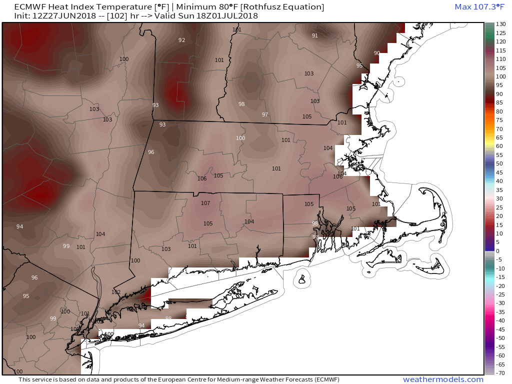
The core of our heat ridge will be overhead, the air mass will be at its hottest, and the wind turns a little more southwesterly. This will bring uncomfortable heat and humidity with dewpoints rising well into the 60s and high temperatures well into the 90s. Combine the two, and heat index values could reach the 95-110F range...so heat advisories/warnings may be posted by the NWS. It's going to be a lazy, hazy, take it easy pair of days where strenuous activity would be discouraged except for early morning and later evening hours when the sun is low in the sky. Monday's dewpoints may be in the 70s which by far would make it the most uncomfortable day of the year thus far.
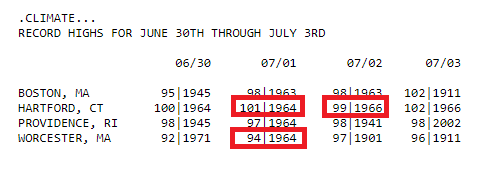
The southwest breeze means the best chance for relief will be along the South Coast, Cape, and Islands. A beach trip, ice cream, and plenty of water is the way to go! Sunday and Monday have the best chance of setting some records, but without a more WSW wind I think it will be fairly tough to do. The marks are very high this time of year. I highlighted the ones that I think have the best chance of being tied or broken.
The Rest Of 4th Of July Week -
It doesn't look like we'll be talking mid/upper 90s, but mid 80s to low 90s will likely last right on through *next* weekend. Again, some beach relief will be the way to go during a long hot stretch with some coastal breezes helping out. But inland areas should keep on baking. There aren't any organized systems approaching, but a diffuse front could set off a few pop-up storms on Tuesday and Wednesday for the 4th of July. Whether or not those can manage to materialize will be a little clearer as we get closer.
As we head into the end of the week and the core of the heat dome shifts over the central U.S., we'll have a chance to nab some MCS (mesoscale convective system) storms/rains as clusters ride along the northern periphery of the big heat. That will be our next chance for any decent rainfall after Thursday.