A Cold And Stormy Marathon Monday Forecast
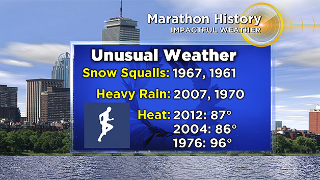
BOSTON (CBS) - When all the miles are logged in the heart of winter, many runners wonder what is ahead of them in mid-April. We certainly have seen it all! From searing summer heat to snow squalls, nor'easters and wind storms...just about everything has blown through the marathon course over the years. Many were probably thinking snow was in the cards this time around with so much chilly weather in March and early April. And it's not far off. Cold air this weekend will give way to raw and windy conditions on Monday.
(WBZ-TV graphic)
For those who have made the journey into Boston from other parts of the country or world, it's going to be a bit of a rough sightseeing weekend in the Hub. A strong cold front drops down across the region on Saturday, bringing temperatures down into the 40s region-wide by the afternoon and 30s heading into Saturday evening. Some low clouds and drizzle will also fill in as the day wears on from northeast to southwest across the area. As a northeast wind picks up, it'll be a full winter-feel by Saturday evening.
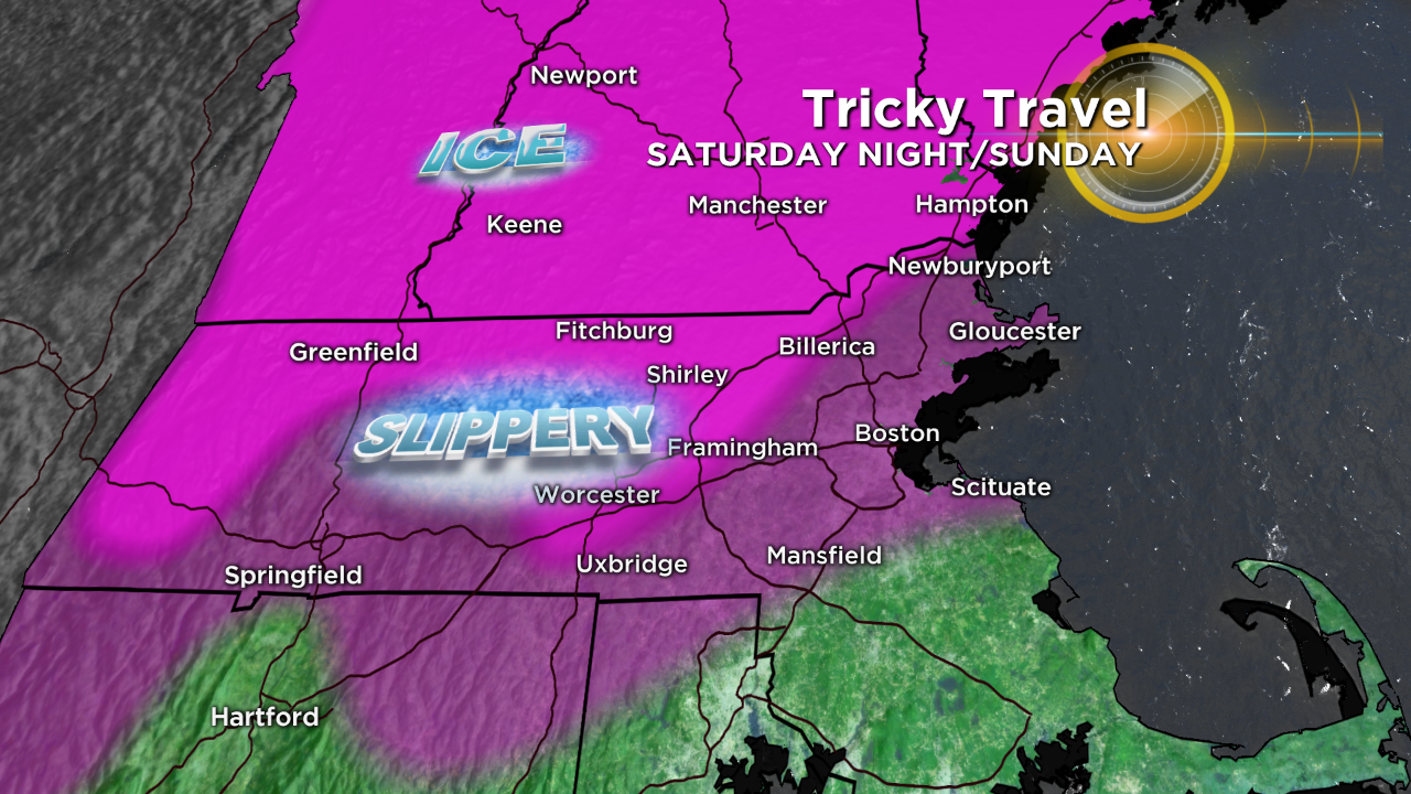
Believe it or not here in mid-April, the main concern Saturday night through Sunday night will be ice! While huge amounts are not expected, scattered areas of freezing rain and sleet are likely Saturday night all the way through early Monday morning across the region. That really speaks to the unusual nature of the cold that's pouring down out of Canada. DPW crews will likely have to be out treating roadways and the subfreezing air may make it south of Boston by Sunday morning. So even in the city, icy surfaces will be possible. I wouldn't rule out some sleet pellets all the way to the South Coast.
(WBZ-TV graphic)
The higher terrain will see the worst of it and the longest duration of icy conditions, starting by 9pm or so Saturday evening and going right through the morning hours on Monday. From Worcester-north, it may as well be February.
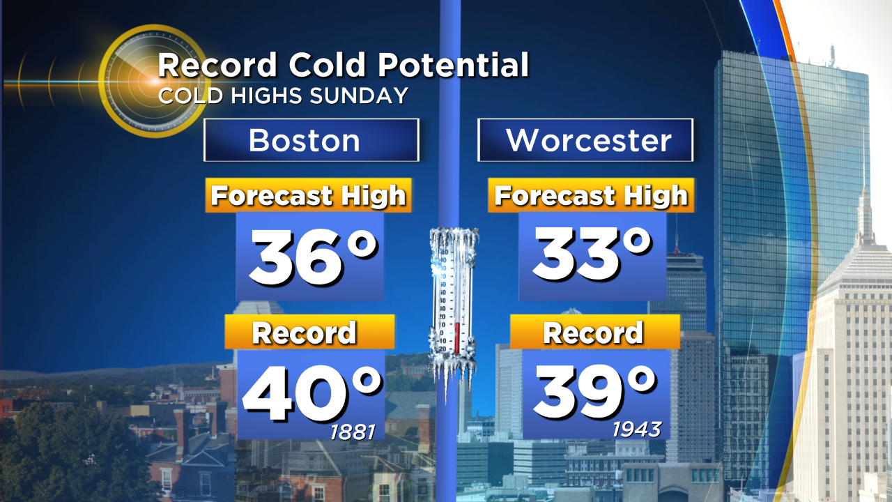
Those temperatures are cold enough to set records, are perhaps shatter them on Sunday. The forecast high for Boston is 36F, with the current coldest high temp for the date being 40F set way back in 1881. This is pretty extreme stuff for the time of year. The combination of the cold and drizzle/showers may mean the Red Sox game will get postponed on Sunday. At the very least, it'll be a miserable day at the ballpark.
(WBZ-TV graphic)
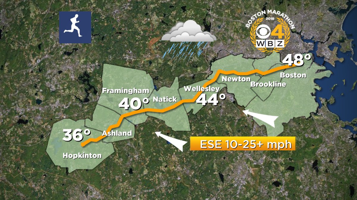
Then we get to the big day. Conditions will start out cold and showery, then become windier and hopefully a bit milder as we head into the afternoon. But as the milder air noses in, heavy downpours will become more likely. There is even a risk of some embedded thunder in that line of afternoon/evening downpours. It's likely this will have the greatest impact on runners in waves 3 and 4.
As for the winds, it will likely be a headwind through the morning out of the east. Not overly windy to start for the elite runners and starting waves, but the winds will increase as the day wears on and with closer proximity to Boston. Some gusts over 40mph will be possible during the afternoon, especially near downtown Boston and around any downpours that move through. The morning's easterly wind turns more ESE and eventually SE later in the afternoon.
In short, it's going to be a difficult day out there on the course. There may very well be some hypothermia cases to monitor. Do your best to stay warm and dry!
Here's the full timeline for the day.
MARATHON MONDAY FORECAST
7 a.m. Monday
Hopkinton: 36 degrees, cloudy and drizzly. Wind ENE 6-18 mph.
Boston: 38 degrees, cloudy and drizzly. Wind ENE 10-20 mph.
9 a.m. Monday
Hopkinton: 37 degrees, clouds and showers. Wind E 10-20 mph.
Boston: 40 degrees, clouds and showers. Wind E 10-25 mph.
11 a.m. Monday
Hopkinton: 44 degrees, cloudy with scattered downpours. Wind ESE 10-25 mph.
Boston/Fenway: 46 degrees, cloudy with light rain showers. Wind ESE 12-25 mph.
1 p.m. Monday
Hopkinton: 47 degrees, scattered downpours. Wind SE 15-30 mph.
Boston: 49 degrees, scattered downpours. Wind SE 15-35 mph.
3 p.m. Monday
Hopkinton: 49 degrees, heavier showers. Wind SE 15-25+ mph.
Boston: 51 degrees, heavier showers with embedded thunder/lightning possible. Wind SE 15-35+ mph.
5 p.m. Monday
Hopkinton: 50 degrees, downpours with embedded thunder. Wind SE 15-35 mph.
Boston: 52 degrees, downpours with embedded thunder. Wind SE 15-35+ mph.
Follow Eric on Twitter @ericfisher