April Antics: Wild Weather Swings This Weekend
Find Eric Fisher on Twitter and Facebook
Well the snowflakes were flying again on Tuesday and the natives are getting restless. My tulips have been up since mid-February and are waiting on warmer temperatures like Judge Smails waited for the final putt at Bushwood. WELL? WE'RE WAITING.
Some good and bad news. Good: warmer air is sneaking in this week. Bad: It's brief. And even the stuff we're getting is tenuous. It's a difficult forecast to cram into 2 minutes and 30 seconds on air so I thought a more in-depth post was in order to break it down day by day.
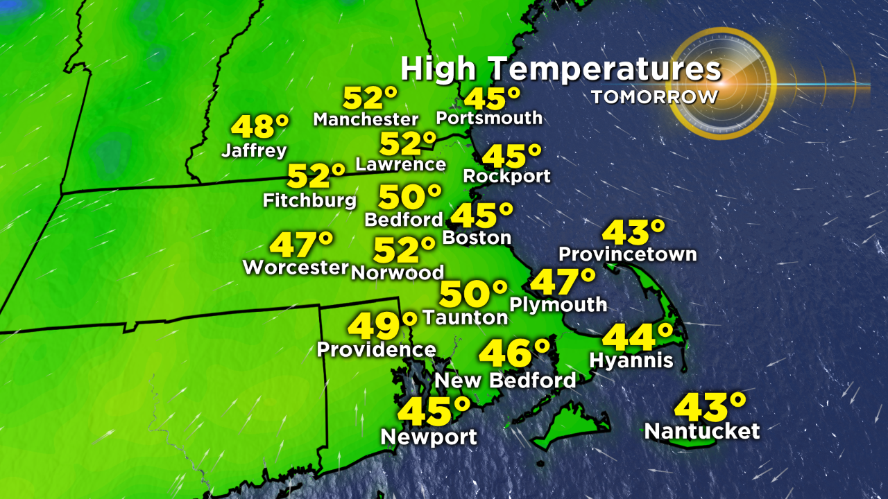
The 'warm-up' starts on Wednesday, though it's a slow start. We're talking 40s to near 50, with the best odds of touching or topping 50 degrees between the 95 and 495 corridors. Inside of 95 there will likely be some coastal cloudiness to battle and when that relents a light sea breeze keeping temperatures stuck in the 40s. Considering there was little sun on Tuesday and most barely got above 40 degrees...it's an improvement! We'll take it.
Thursday conditions allow for us to do a little better. As the flow goes more south-southwesterly a milder air mass heads in. I wouldn't call it an all-around beautiful day because sunshine will likely stick around for about half the day. Our best odds of blue skies are during the morning to midday hours, and then it fades behind rapidly increasing clouds from the west. As the warm front lifts across New England, we'll likely get some rain showers during the afternoon and evening as well. But hey, it's a milder variety of rain shower! Highs should hit the 55-60F range...and if we can wrestle enough sunshine out of it a few towns could top 60F. That at least qualifies for a feel of spring and dew points will be higher which helps to add to that feeling.
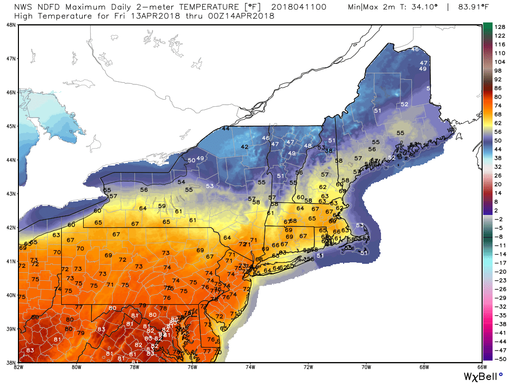
NWS forecast highs for Friday across the Northeast
On Friday, we're still near a battle ground between the mild air and the cooler air but I think the milder conditions will prevail. The one fly in the ointment to watch for is a band of clouds that will move through during the day. The sky-cover forecast is tricky, but I would lean grayer (with a chance of a shower) toward northern Massachusetts/New Hampshire/Vermont and brighter south of the NH/MA line. The warmer air mass should help us pop into the 60s, which in fact could be our warmest day since February (needs to top 64F in Boston for that). We've only topped 60 degrees once since March 2nd! Good grief.
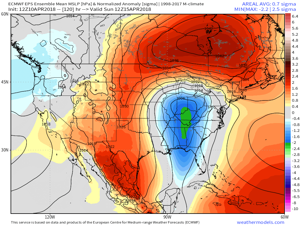
An anomalous area of cold high pressure rotates over the top of our developing storm, halting the progress of warm air and pushing it back to the southwest on Saturday.
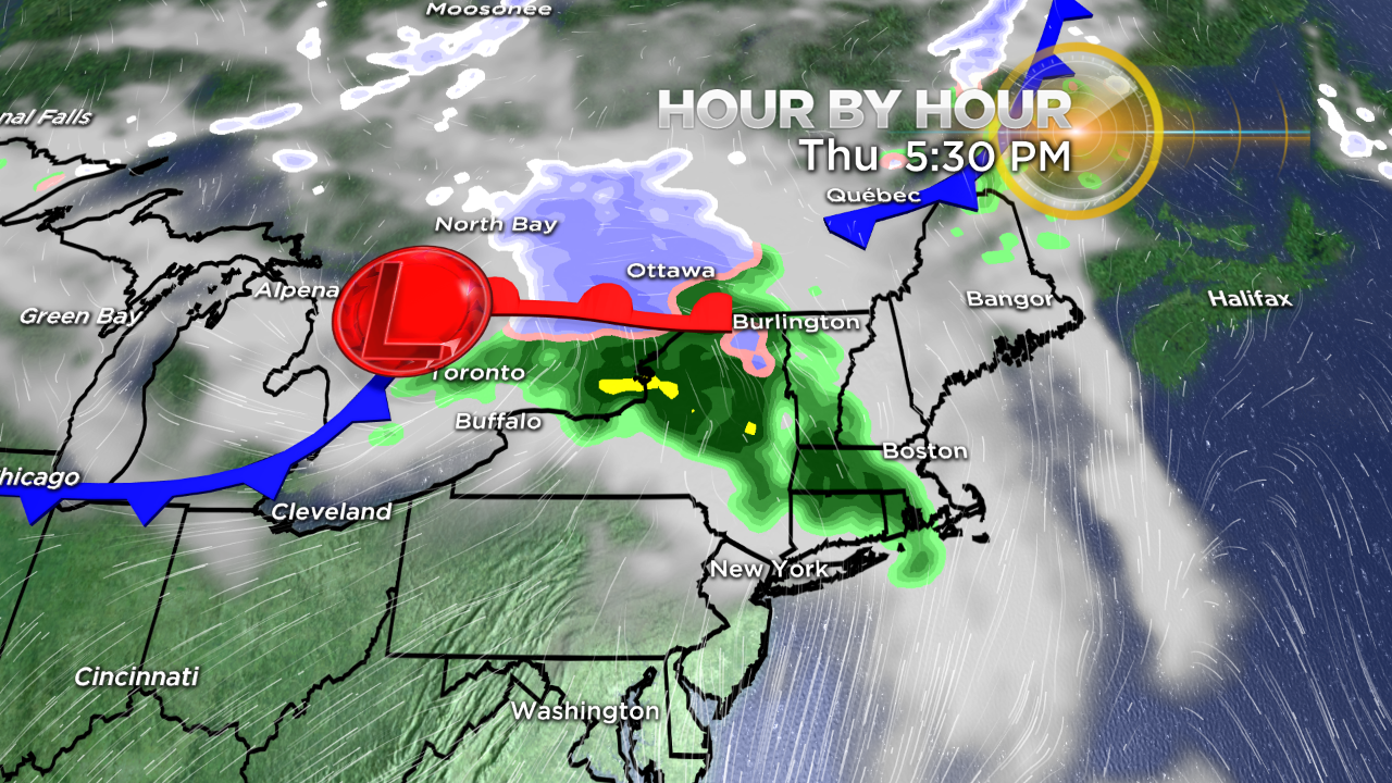
Saturday is the real 'interesting' day from a weather standpoint and the one that will probably lead to some confusion for those figuring out what the heck to expect in their town. The answer is, it depends on the hour. What we have is a strong storm moving into the Midwest with severe storms on the warm side and a snowstorm on the cold side (Upper Midwest). At the same time, a strong area of arctic high pressure will be nosing down out of Canada, sitting like a hat on top of the storm. In the midst of winter, this is a ripe setup for an ice storm. In mid-April, we may *still* get ice in New England which is a testament to how cold the air mass over Canada is right now. But one thing we can bank on - this area of high pressure will force a backdoor front down across the region and it will be a doozy which major temperature contrasts on either side.
This is a depiction of wind direction around midday on Saturday. You can see the sweep of colder northeast winds pushing down across northeastern Massachusetts and NH/ME, while the very warm southwesterly winds are holding across western zones. How long we can live in the southwesterlies determines max temps before the rapid 20 to 30 degree crash in temps.
These types of backdoor fronts are classic in April around here, but nevertheless they are wild to watch. The end result for us will all come down to a few hours of timing with this front. If it swoops down out of northern New England starting around midday, many areas will soar into the 60s and 70s before its arrival. If it gets shunted down across our area early in the morning, forget about it. So the speed of that Canadian high is very important. Plus, the cold ocean allows for a quick onshore wind to develop once heating commences.
If you're looking for the warmth, odds for 65+ temperatures favor central/western Massachusetts down toward Connecticut and Rhode Island. Farther removed from the front, there will be time for a beautiful spring morning before the crash. If you're in New Hampshire, Maine, or northeastern Massachusetts...chances don't look too good for warmth. The front should move through pretty early in the day ushering in chilly 40s from the north. The most difficult area to pin down will be MetroWest to Boston. The high in Boston could literally be anywhere from 50 to 70 degrees. Hopefully we can nail down the exact timing of this frontal passage within the next couple days so it'll be easier to plan for. But again, the general idea is the farther northeast you are, the lower your chances for any warm temperatures on Saturday.
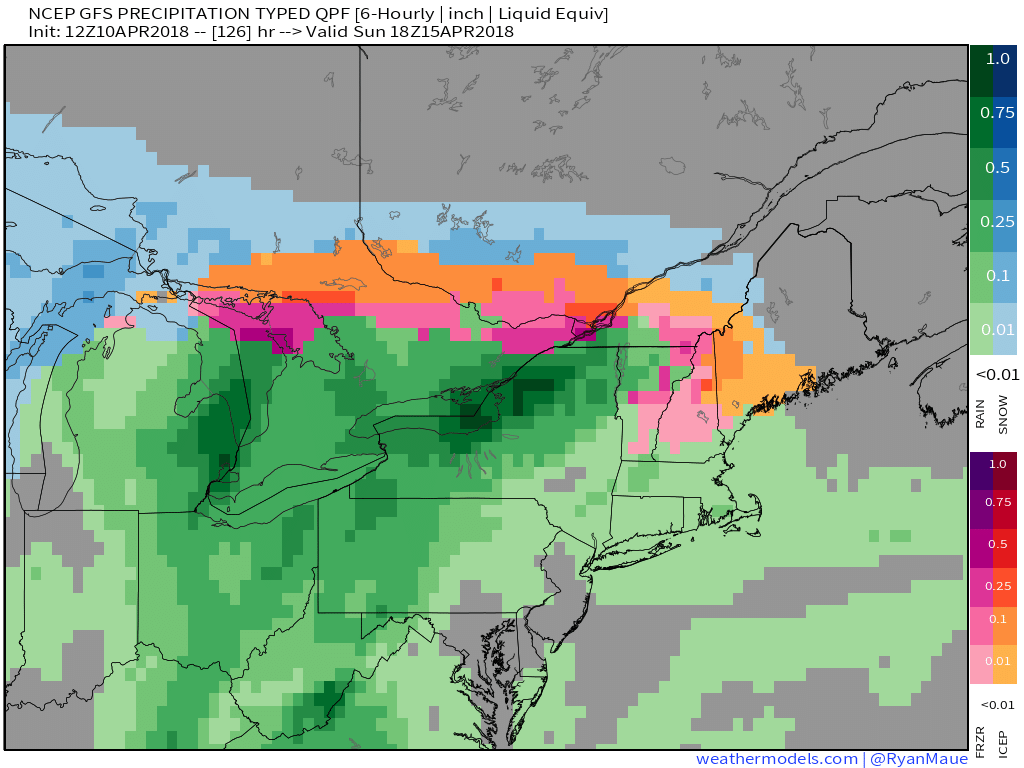
Wintry precipitation looks to be a slam dunk across northern New England late Saturday into Sunday with very cold air for mid-April in place. Likely a mixture of snow, sleet, and freezing rain.
As we dip into Saturday night and Sunday, the air is so cold that we may set some records and even see some freezing rain across higher elevations of southern New England. There isn't a whole lot of precipitation moving in, but enough for an icy glaze. Highs for most should get locked up in the 30s on Sunday with clouds and drizzle. The record coldest high in Boston for the date is 40F set wayyyy back in 1881 and I think it's in jeopardy. The feed of cold air from the north, combined with water temps near 40F, will make it possible. Not exactly what you're hoping for in mid-April.
That brings us to Marathon Monday. One thing we can definitely rule out is any kind of heat this year, which is arguably the hardest weather to run in. Rain chances, however, look high. While I'd peg the chances of rain pretty darn close to 90%, it's still too early to know for sure when the steadiest/heaviest rain will move through. That can make a HUGE difference for runners. A band of heavy rain in prime marathon time is a lot different than drizzle or light showers. So we'll be focusing on nailing down the timing of rainfall in the days to come.
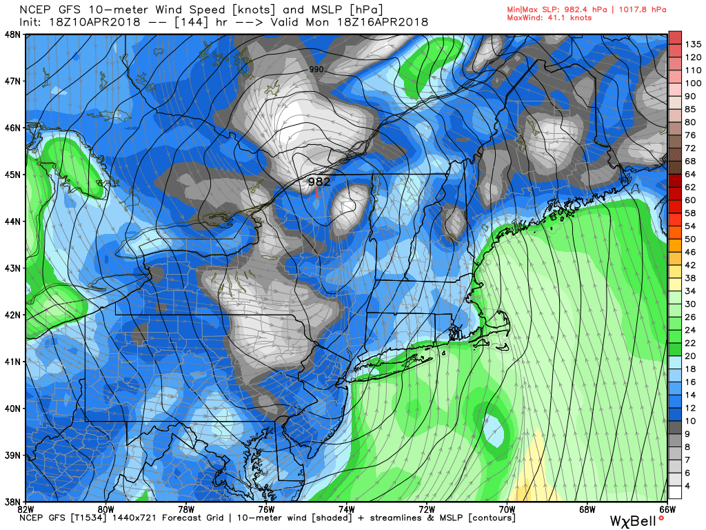
The current GFS has a strong, consolidated area of low pressure tracking to our west, which provides a milder marathon forecast.
The other issue at hand is temperature. There are two camps for that part of the equation. The GFS has a strong parent low heading up to our northwest, which would allow winds to go southerly and boost highs into the 50s and low 60s. The Euro spins up a secondary area of low pressure close to the coast, which would halt the progress of milder air and keep the winds more easterly. So that's a two-fold impact. An east wind is straight in your face on most of the course, which is more protected from a southerly wind. I'd lean more toward the Euro solution of colder conditions (40s) for now but it'll take a couple more days before the details shake out. And no question for this one the devil is in the details!
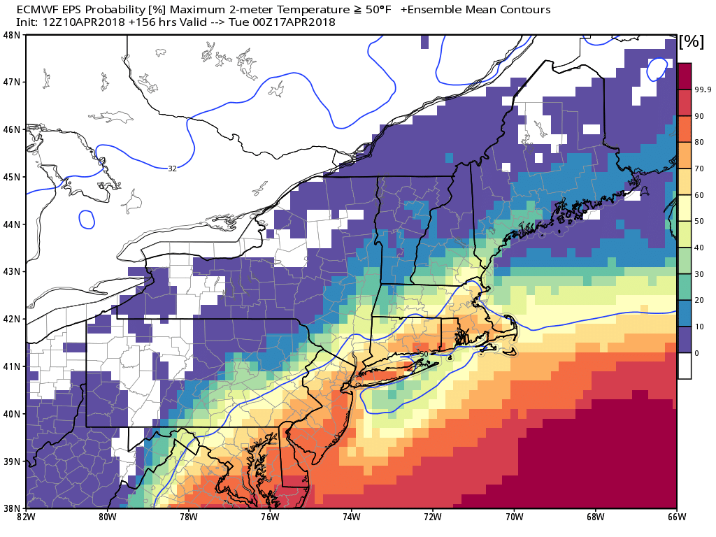
There is at least some hope that it won't be a very cold rain! While the Euro operational model guidance keeps us in the 30s and 40s, the ensemble probability gives good odds of highs over 50 degrees. Would much prefer that outcome.