Another Nor'easter On Its Way With A Crushing, Direct Hit Possible
BOSTON (CBS) --Another nor'easter is on its way and it has the potential to be a crushing, direct hit.
For the last several days, we have been monitoring the progression of two bundles of energy in the jet stream. The southern stream system was projected to initiate storm development off the Carolinas. To complicate the setup, the northern stream system was digging southeastward from over the Great Lakes. It was all about timing and phasing of these bundles.
Third Nor'Easter Coming To Boston Tuesday
Earlier in the game, it seemed more likely that the faster speed of the southern system would yield no phasing hence the ocean storm would be farther out to sea and the second system would only contribute lighter snows here on Tuesday.
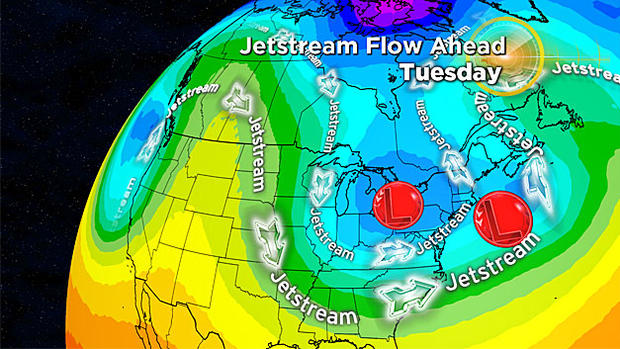
Model guidance over the past 24 hours has revealed that there might be more phasing of the bundles which would energize this ocean storm closer to New England.
However, I am not completely convinced of that until I see more data confirmation in the next 24 hours.
Consequently, the potential is greater now for a more significant snow event but I am not pulling out all the stops yet. On Friday, the odds of the storm passing over the 40N/70W benchmark giving us a raging nor'easter were 30%! At this point now, the odds of that happening are somewhat greater.
So here we go again- how to handle this hot potato?
Possible Outcomes:
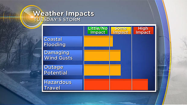
A couple scenarios to point out at this time. Some models have the closer track, which would mean higher snowfall, minor coastal flooding, and wind gusts over 60 mph. A further out to sea track, which some model updates still have, will still give us several inches of snow.
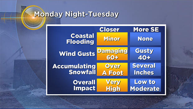
But maybe no coastal flooding and lower wind gust speeds, which could help cut down on outage potential. We will be able to see model agreement in the next couple model runs. Stay tuned!
Blizzard Potential:
With the wind forecast and heavy snowfall we may be close to blizzard conditions along the coast.
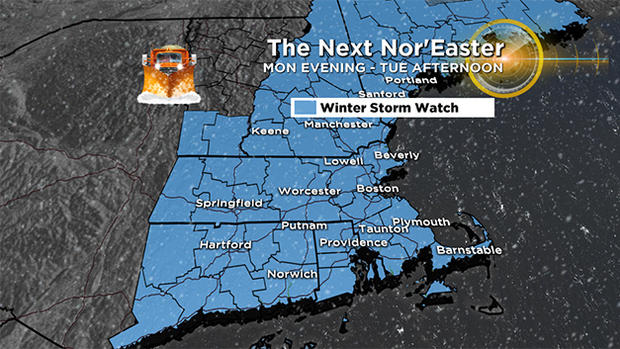
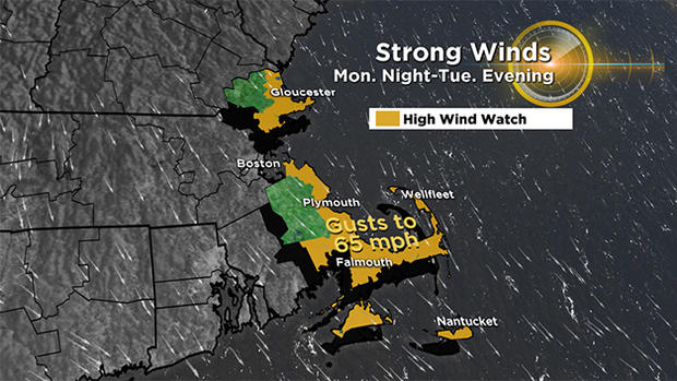
A winter storm watch is up for Tuesday, this could be updated to a winter storm warning or blizzard warning. We also have a high wind watch for Cape Ann, Cape Cod, islands and the south shore. Gusts may reach 65 mph.
A blizzard is by definition from the NOAA glossary:
Blizzard (abbrev. BLZD) - A blizzard means that the following conditions are expected to prevail for a period of three hours or longer:
• Sustained wind or frequent gusts to 35 miles an hour or greater; and
• Considerable falling and/or blowing snow (i.e., reducing visibility frequently to less than ¼ mile)
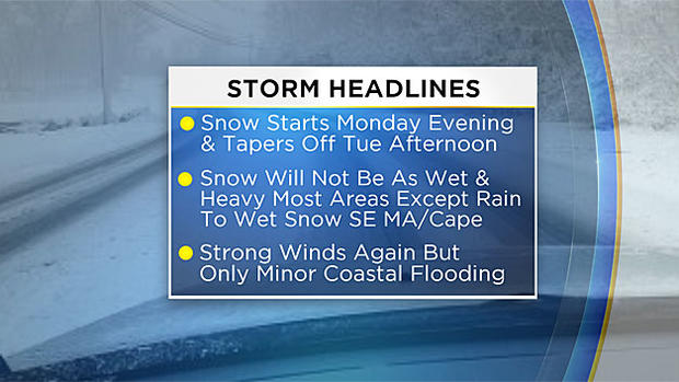
Storm Headlines:
While the surface temperatures may hover in the 28-33 degree range, the atmosphere is colder this time around so the snow consistency SHOULD not be as pasty wet and heavily-weighted most areas except over southeastern MA where the potential for more tree damage and power outages would occur.
The snow to water ratio would be about 8:1 down there but closer to an average at 10:1 in the Boston area with perhaps a fluffier 12-14:1 west-northwest of Boston.
The wind will become powerful again but not reaching the magnitude of the first big cyclone last weekend. It should be more comparable to the wind of the previous storm this past Wednesday.
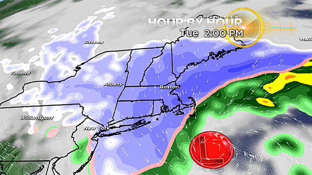
The snow will commence by mid-late evening Monday and ramp up through the morning hours of Tuesday.
Timing:
There will probably be a spell of rain over extreme southeastern MA and on Cape Cod tomorrow night before a switch to snow from west to east out over much of the Cape.
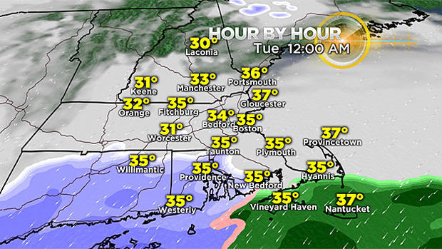
The snow is expected to be moderate to heavy at times.
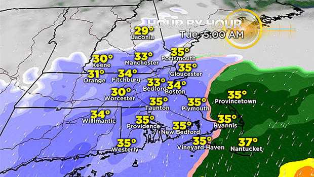
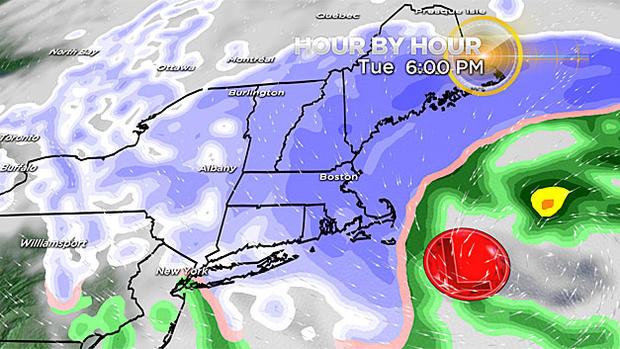
Visibility may be reduced to a quarter mile or less at times in near blizzard conditions Tuesday morning into the afternoon with a tapering to lighter snows and flurries late in the day lasting into Tuesday night and early Wednesday.
Amounts:
My preliminary prediction is calling for 6" up to perhaps a foot across much of eastern MA.
Lower accumulations are anticipated over western New England farther away from the storm center.
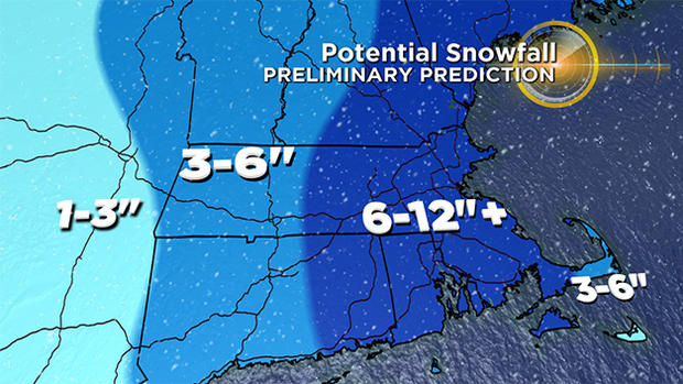
Amounts over Cape Cod into southeastern Plymouth County are tentative due to the uncertainty of timing from rain to snow down there. Undoubtedly, there will be some massaging of these snow bands as we get closer to the event tomorrow.
Examination of updated guidance in the next 24 hours will be paramount to increasing forecast confidence.
Wind:
The strongest wind gusts in the range of 40 to 60 mph along the coast especially over Cape Cod and 20-40 mph farther inland will most likely happen Tuesday morning into the first half of the afternoon.
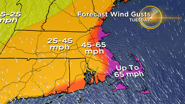
The direction will start from the northeast and back more northerly by midday Tuesday then northwest to westerly late in the day and evening as they gradually decrease.
Tides:
The only tide that could be an issue will be the high tide occurring near and just after 9am Tuesday.
There will be a storm surge associated with that tide due to the onshore component of the wind.
Thankfully, the scheduled height of this tide is down to 9.2 feet which is quite low compared to the 11.5 feet of last weekend.
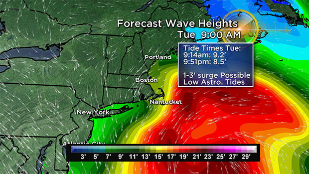
A storm surge of near 3 feet would be needed to pose additional threats of flooding. At this stage of the game, it appears that only minor flooding of more vulnerable weakened shore areas is the biggest threat.
After that, the evening tide on Tuesday is even lower at 8.5 feet and that linked with an offshore wind, there should not be any flooding. Seas will become agitated again with big breakers causing more beach erosion.
March can be a fickle and frustrating month.
It is even more upsetting when we have been spoiled by an all-time warmest February!
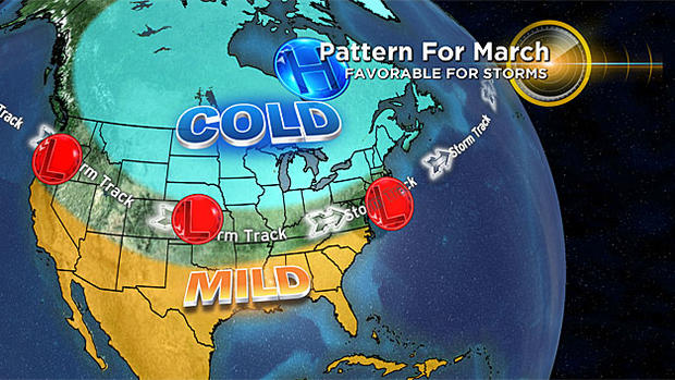
In this La Nina regime, that was triggered in part by a strong ridge of high pressure over the southeastern U.S. and all of the storms tracked well west of New England.
A pattern reversal commenced last week as a result of developing high latitude blocking which disrupts the movement of weather features across Canada. I had been anticipating this to unfold three weeks ago following a sudden stratospheric warming episode.
This phenomenon generates cold air at lower levels associated with building air pressure. This forces a storm track farther south. So we got our front-loaded winter, had an elongated break in February and now we deal with winter part two. This back-loaded segment may produce additional storms of snow or rain this month as an active storm track remains in place.
Looking way ahead, there are global signs that our spring will eventually turn out quite warm!
Interestingly and coincidentally, Tuesday's nor'easter will be occurring on the 25th anniversary of the March 1993 Superstorm which crushed much of the eastern part of this nation from March 12-14. Forty percent of the country's population was impacted by this Storm Of The Century!
It started out as an extratropical low-pressure system over the Gulf of Mexico. It turned into a beast and produced record snows ranging from 4" in the Florida Panhandle to 35" North Georgia to 60" in the Great Smoky Mountains.
Ten million customers lost power! There were 60,000 lightning strikes and a vicious squall line produced 11 deadly tornadoes in Florida! There were 47 fatalities, many of which were drownings from a terrible storm surge in Florida. There were 208 deaths related to this storm. Boston received its share of the superstorm on Saturday, March 13 into early Sunday, March 14, 1993.
The peak gust in the city was 81 mph just after 5pm on 3/13 and the second lowest air pressure of 28.49" was recorded at 4:17am on 3/14. The band of snow was moving fast but it was furious for a few hours in the city where 12.8" fell. All-time record low air pressures were set from GA to PA!
This will not be repeated on Tuesday! Whew!
Check back with us for updates today through the storm on Tuesday on WBZ-TV and CBSBoston.com.