Only In New England: Plowable Snow, Then 70 Degrees?
BOSTON (CBS) – Go figure! We're in the middle of a mild weather pattern but a snow event is going to materialize Saturday night.
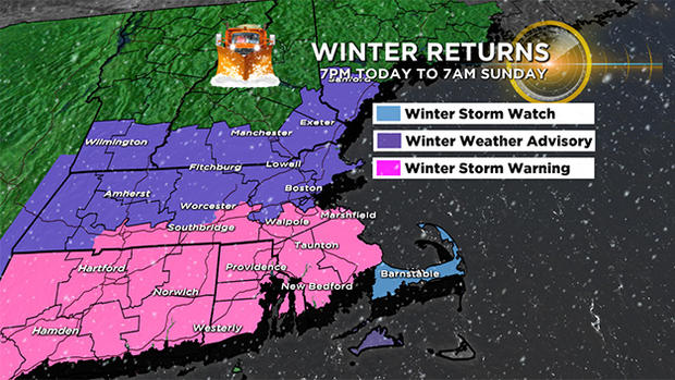
Consequently, the National Weather Service Forecast Office in Taunton has issued a warning, an advisory and a watch for the region as seen on this map.
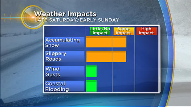
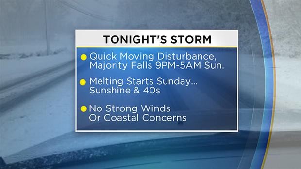
The impact will be much reduced in this storm because it will be occurring overnight with a rapid departure and clearing first thing tomorrow morning. There will not be any really gusty winds or coastal flooding issues to deal with and the snow amounts will be mainly in the low to moderate range.
TOTALS
It is going to be just cold enough to generate snow from the top to the bottom of the precipitation channel. The snow will produce slippery conditions as the evening progresses and the snow tempo increases.
The threshold for snow to rain will probably me met from time to time on the New England South Coast and certainly over much of Cape Cod and the Islands where 1-3 inches is most likely.
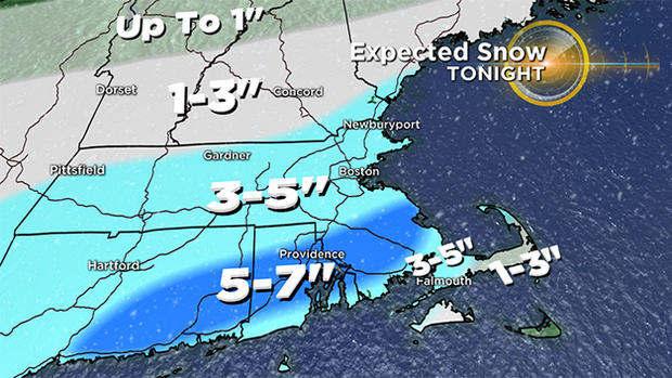
Milder air dictates at least a mixing if not a complete change or waffling back and forth in those locations. Less than an inch or no snow at all is probable on Nantucket.
Much of Massachusetts will receive 3-5 inches except portions of southeastern MA where a band of 5 inches up to 7 inches is possible extending across parts of Plymouth County to Bristol County into central RI and southeastern CT.
The snow accumulation will drop off to mainly 1-3 inches across northern New England up to the Lakes Region then probably less than an inch extending up to the far northern ski resorts. Any slight twist or turn in the storm path and intensity may require some minor tweaking of this projected snowfall late today.
TIMING
The snow should arrive approximately between 8 and 9 pm in the Boston area and 1-2 hours earlier farther west. Road conditions will quickly deteriorate as heavier snow spreads across the region making roads greasy and slushy eventually.
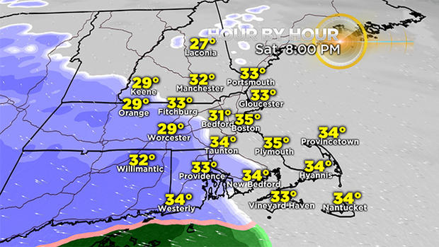
The snow will be more pasty and wet rather than dry and fluffy most areas except well northwest of the Boston area.
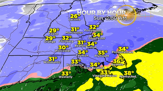
It will be a decent thumping of wet snow for a few to several hours with an intensity decrease before dawn and an ending near or just after 6 a.m. along the coast.
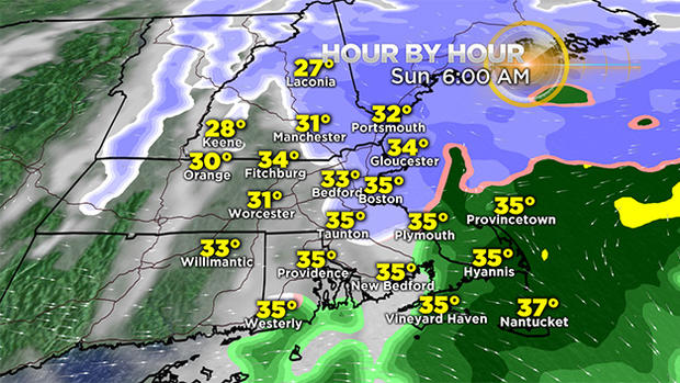
With plowing and treatment, road conditions should improve rapidly toward dawn and certainly after that. I expect many of the major roads will be all dry by late morning.
COMING ATTRACTIONS
It has been an interesting winter that was front loaded with decent snow the longest subfreezing spell in about 100 years. After that, the switch was flipped and the meltdown generated high temperatures exceeding 60 on a couple of days accompanied by unusually humid conditions in January.
We have been on a seemingly everlasting roller coaster ride which is destined to gyrate into March. There have been only a handful of days near freezing in February and the mean temperature for the month is at a robust +3.2 degrees. That will climb higher as some unusually warm weather visits the area this upcoming week and melts all of the snow down here!
A strong ridge of high pressure over the southeastern U.S. and extending offshore will result in temperatures reaching near record high levels on Tuesday then breaking them on Wednesday. The record for February 21 may be smashed by a whopping 9 or 10 degrees!

It COULD match the 73 degrees that occurred on the February school vacation week last year, specifically on the 24th. Interestingly, the only previous reading at 70 or higher in Boston in February occurred also on the 24th in 1985.
Please note that it will be much cooler on the New England South Coast and the Cape & Islands area this coming week with highs there in the upper 40s to lower 50s thanks to the southwesterly wind blowing up across the cold Atlantic Ocean. The warmest air will be near and farther west-northwest of Boston.
Beyond that, a robust sudden stratospheric warming event unfolding across northern North America will produce a big change in the weather pattern as massive high air pressure builds across Canada and arctic air strengthens underneath it. That chill will expand into portions of our nation including the Northeast.
A blocky weather pattern is typical and that has the potential to create a colder and snowier regime for us. If the block becomes too strong to the north which is not anticipated presently, any potential storms may be deflected too far south like what happened in 2009-10 when new seasonal snowfall records were established in Baltimore, Washington and Philadelphia.
In any event, we will be keeping a CBS eye during March to see how this whole pattern will shake out. The potential exists that a chunk of the month may qualify for "March Madness."