Heaviest Snow Thursday Likely In Eastern Massachusetts
BOSTON (CBS) - New year, same weather. After finishing 2017 off with a brutally cold stretch, 2018 is looking no better.
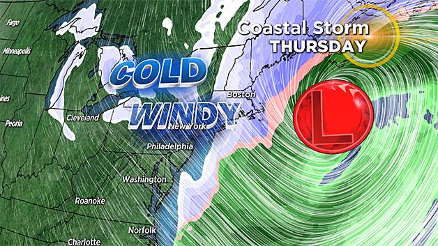
In fact, temperatures are likely to get even colder AND we are going to come dangerously close to a very large and powerful coastal storm.
Happy New Year!
Where to begin? Well, Monday morning may have felt very much like rock bottom. Temperatures dropped to 0 degrees in Boston, the coldest temperature in the city since February of 2016 (nearly 2 years).
Another day (Monday) with high temperatures below 20 makes it 6 in a row for Boston! This is VERY unusual. In fact, it is one shy of a record set back in January of 1918 (7 days).
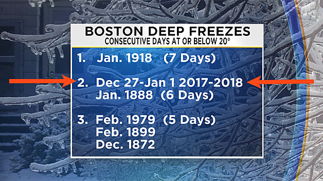
After a day in the teens on Tuesday, we should finally break the string of sub-20 degree days on Wednesday - YAHOOO! The highs will only be in the 20's, but any progress is good progress at this point.
So what's the deal with that Thursday snowstorm?
This one means business.
During the day on Wednesday an area of low pressure will begin to form and deepen of the Florida Coast. In the next 24 hours, the storm will ride up the East Coast (offshore), and undergo what we call "bombogenesis." This is a term we typically only break out a few times per year, essentially it means a very rapidly deepening low pressure system (24 millibars in 24 hours).
Anytime you hear bombogenesis in the winter along the East Coast, several red flags are raised.
Combine this with an Arctic air mass sitting over New England and a Supermoon with astronomically high tides and you have a recipe for trouble.
Clearly IF this storm were to take a track close to our coastline, this would be a major nor'easter, perhaps even a blizzard. As of right now, it appears as though the storm will track just a bit farther east than the classic storm-track for New England.
This is key!
While it is still too early to lock this forecast in, signs over the last 24-48 hours have been for a fringing effect and not a direct hit.
So assuming this forecast holds, what are we in for?
Snow would start during Thursday morning, likely around or just after the morning commute. It may even start as a bit of rain over the Cape and Islands. The snow intensity would be light to moderate in the morning (heaviest in southeast Mass.) and the winds would start to crank up out of the northeast, gusting to 40+ at the coastline.
This will be a fast moving storm. The peak snowfall intensity will likely only last for about 6 hours, between noon and 6 p.m.
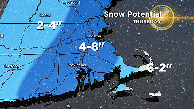
Given the current forecast track, the heaviest snow would be located over eastern-most Massachusetts including the immediate coastline and especially outer Cape Cod and Nantucket.
Wind gusts in the heaviest snow bands could easily top 50 mph (out of the north) while inland the winds would be more like 25-to-45 mph.
By evening, the storm is moving quickly past our latitude, headed for Nova Scotia. The snow is tapering off and winds are shifting to the north-northwest (25-45mph).
So How Much?
Again, there is still much TBD. Right now given the current forecast, snowfall amounts would be heaviest in coastal Mass., southeastern Mass. and over the Cape and Islands, perhaps a 4-to-8 inches range.
I stress again that this forecast is preliminary and likely to change with even the smallest shift in track.
Coastal Flood Potential
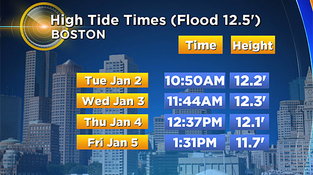
We will have some of the highest tides of 2018 this week.
Even without a storm we would likely have some minor coastal flooding, so this situation will need to be monitored very closely. High tide on Thursday is just after noon in Boston.
Currently, we are not anticipating a major flooding event with most of the strongest winds being out of the north and eventually northwest (mainly offshore).
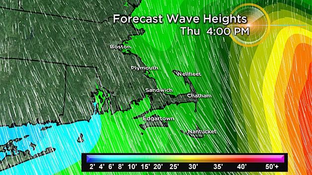
With a closer storm track though, this could become a major issue, stay tuned! Regardless of exact track, this storm will rough up the seas in a big way. Wave heights of 10-20 feet are expected just offshore of Cape Cod.
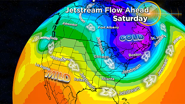
Next Up… The Coldest Blast Yet!
Believe it or not, we likely haven't seen the coldest temperatures just yet. The cold blast behind this Thursday storm will take the Arctic chill to yet another level.
Temperatures this weekend could possibly shatter records in New England. Morning lows both Saturday and Sunday may be well below zero (including in Boston).
The high temperature on Saturday may never reach 0 degrees in some areas!
Needless to say, any power outages caused by the Thursday storm would be devastating in that kind of cold, even more reason to be thankful IF the storm pushes farther out to sea!
This is one of those storms that bears extra close attention. Every forecast cycle and update will be vitally important. Please stay tuned to WBZ-TV and CBSBoston.com for the very latest.
Follow Terry on Twitter @TerryWBZ