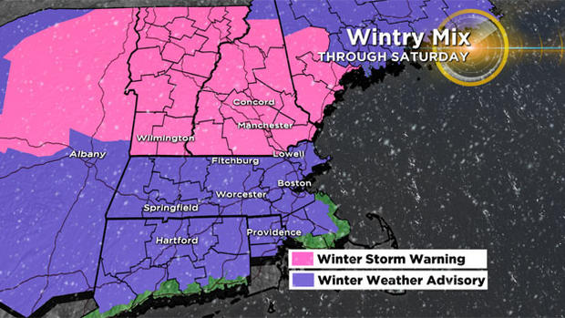
Snow, Ice To Impact Weekend Travel; Potential Christmas Day Storm
BOSTON (CBS) - "Oh the weather outside is frightful…"
Frightful is certainly one way to describe what lies ahead. If you are a lover of winter weather, boy do we have the perfect gift for you! Winter is about to kick it up a notch with an icy mess Friday Night and Saturday, a Christmas Day storm and then a blast of brutally cold air from the Arctic next week. It's the gift that keeps on giving!
Let's step through the next several days and help you find a few windows of opportunity to finish up that holiday shopping!
Friday Night:
The snow in Southern New England is just about done after 7 p.m. The last of the snow will accumulate a bit more in New Hampshire, Vermont and Maine, where 3-6" are likely.
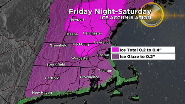
After 7 p.m., a rather thick layer of milder air (above 32 degrees) will move into and over Southern New England. Problem is, the dense, cold air will remain lodged at the surface (where we live). The milder air will ride up and over the cold air, turning the snow to rain above our heads. As the rain nears the ground it will freeze on contact with the subfreezing air/ground (freezing rain), leaving a glaze on most untreated surfaces.
At the same time, this first batch of precipitation will taper off, leaving just some light freezing rain or freezing drizzle for most of Friday night. So, while we will have some icing, it won't accrete (stack up) much just yet.
Travel Impact: Moderate
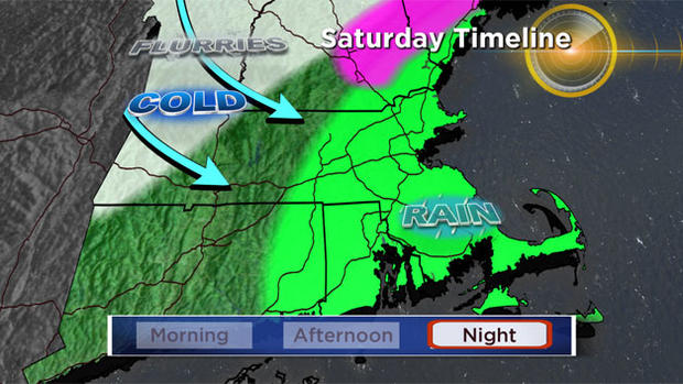
Saturday Morning:
Cold air will continue to drain down from Maine and Canada Friday night into Saturday morning (we call this cold air damning). This will further solidify the cold air in place at ground level and continuing the icing as the light rain falls. This cold air drainage will likely even seep into Boston and perhaps all the way down close to our South Coast.
So again, while the precipitation will be light through early Saturday, it will likely cause some hazardous conditions for a good portion of the area. During Saturday morning, after dawn, the next wave of rain will move in, this one heavier than the first. This is where our concern level really rises.
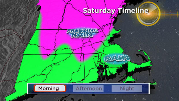
While Boston, southeastern MA and most of Rhode Island will likely tick just above freezing, most areas north and west of Boston will remain slightly below 32 degrees. This is the most critical time period in this entire event. At this point, we expect ice to adhere to and accrete on all untreated surfaces, perhaps as much as .25" or more. Once you pass the .25" threshold, you can start getting some tree damage and power outage issues. At this point we do not anticipate any widespread problems, but a few isolated outages cannot be ruled out, especially in parts of New Hampshire and Maine.
Travel Impact: High/Severe
Saturday afternoon/evening:
The moderate to heavy rain/freezing rain continue to fall Saturday afternoon as temperatures try to nudge their way up a degree or two. This slight change in temperatures will likely save some parts of the area (close to and inside 495 perhaps) from a more serious ice event.
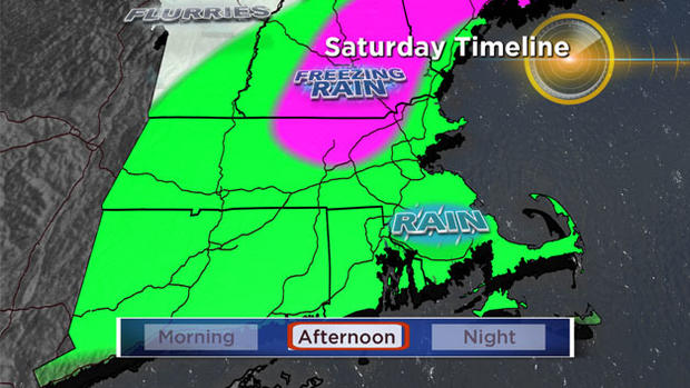
Some areas however, (including large areas in New Hampshire, Maine and pockets in northern MA) will remain stuck just below 32 degrees. Those towns unable to nudge above 32 will undoubtedly see significant ice accretion and potentially some isolated tree/power line damage.
Travel Impact: High/Severe (Inland)
Saturday Night/Sunday:
After 7 p.m. Saturday the rain will taper off from west to east. The temperatures will, once again, fall back below freezing by Sunday morning in many locations, refreezing much of the standing water. Sunday will be a partly sunny day, with highs in the mid 30s north of Boston, nearing 40 to the south.
Sunday Travel Impact: Minimal - Moderate (where significant icing occurred)
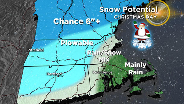
Christmas Day:
It now appears quite likely that we will have some sort of wintry storm Christmas morning. While there are still some things to work out with the event, it looks like there will be a plowable snowfall for a portion of the area!
Few important things to know…
-This will be a quick mover, likely in and out of here in 6-12 hours (approximate timeframe just after midnight to midday).
-This is NOT a major storm…not much wind and no coastal flooding
-There will likely be some areas that get rain…ugh I know, rain on Christmas morning. Southeastern MA stands the best chance of getting wet instead of white and frankly even in Boston and along the immediate North Shore there could be mixing/rain.
-Best chance for plowable snow, north and west of Boston (outside of 128 and certainly outside of 495)…and in particular central and northern New England! More great news for ski areas.
We will of course keep you updated on WBZ-TV and CBSBoston.com throughout the weekend on both storms. Please stay safe and enjoy the holiday!


