Messy, Complicated Weather Pattern Unfolds Before Christmas
BOSTON (CBS) - It's the most wonderful time of the year! Spending time with family, gift giving, tasty meals, and of course a hearty helping of New England weather at its finest! You have to admit, we have been pretty lucky the last few years. The weather surrounding Christmas has been quite tranquil…just check out these high temperatures on Christmas Day in recent years: 59 in 2014, 62 in 2015 and 45 in 2016!
In Boston you really have to go back to 2010 to find any significant snowfall in the days surrounding Christmas, and that year it came on the 26th and 27th (a whopping 18.2"). Snowfall on Christmas Day itself is actually kind of rare. The most snow Boston has ever received on the 25th of December was 3.3", back in 2002 and 1974.
Ok, so what am I getting at? Well, our luck may just be running out. A very messy and complicated weather pattern is about to unfold just as many of you are set to take to the roads, hit the airports and scurry around for your last minute errands.
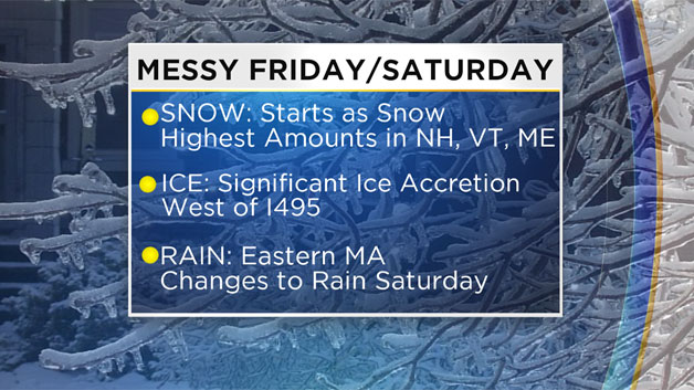
Storm #1: Friday-Saturday
One of those "kitchen sink" storms (you know everything but the kitchen sink…). A messy mix of snow, ice and rain is likely for a good portion of Friday and Saturday.
THE SNOW:
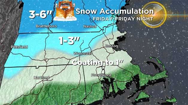
Snow breaks out from west to east early Friday morning (likely before dawn in many areas). The snow will generally be light and located mostly north of the Mass Pike. Light snow continues through the afternoon on Friday, leaving a general coating to an inch along the Pike in Boston…1-3" northwest of the City from 495 outward…and 3-6" up into New Hampshire, Vermont and Maine where the snow will hang on the longest.
THE ICE:
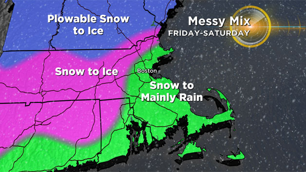
After dark Friday evening, some warming will begin to work its way north above ground level. Expect the snow to change to ice (mainly freezing rain) in most of Connecticut and Rhode Island first, then progress northward into Massachusetts. By Midnight, the snow is just about gone from Massachusetts (still snowing for a large part of Central and Northern New England).

Overnight Saturday, we will be in-between two waves of precipitation…while we wait for the second batch to arrive, there will likely be some light freezing rain/drizzle for most of the night away from the Coastline. Temperatures inland will be stuck in the upper 20s to near 30 all night. After dawn on Saturday, wave #2 moves in largely as rain along the Coast and freezing rain inland.
A significant amount of ice accretion is possible in parts of northwestern Middlesex county, Worcester county and Western MA as well as northern Connecticut and Rhode Island. Some models are indicating .1" to .25" or more of ice building up on untreated surfaces. By midday and afternoon, temperatures will begin making a slow, gradual climb above freezing. However I would expect many areas (such as northern Worcester county and parts of the Connecticut River Valley) to stay perilously close to 32 degrees for most of the day.
THE RAIN:
Clearly the least impactful part of the story, the rain. Generally a half inch to an inch of rain is likely across the area. Not nearly enough for any flooding concerns. Rain may come down heavy at times especially across southeastern MA including Cape Cod and the islands. The rain tapers off Saturday night from west to east before midnight.
Storm #2: Christmas Storm!
I wish I could give as much detailed information on this one as I did the prior storm but it is simply too early to do so. At this point it seems very likely that a storm will form off the southeast coastline of the U.S. on Sunday. Where exactly it goes from there is still to be determined. The possibilities range from a track right over our area, which would lead to rain near the coast and a good deal of snow inland to a complete offshore miss.
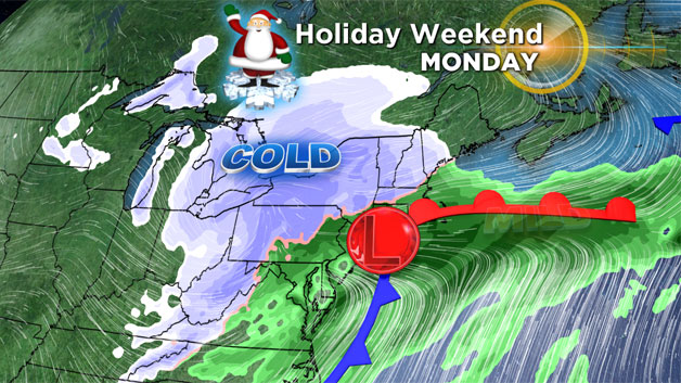
While I am sure many of you would love a fresh coat of snow Christmas morning (and our first white Christmas in many years), I am not sure that a full-fledged winter storm on Christmas day would be pleasing to most. For now, all I can urge you to do is to stay tuned to updated forecasts over the next several days. Typically we are able to hone in on these storm tracks about 48-72 hours out. This would put us sometime in the Friday-Saturday timeframe (right in the middle of storm #1).
We could have new meaning to the old Dean Martin classic after this holiday weekend…
Oh the weather outside is FRIGHTFUL
But the fire is so delightful
And since we've no place to go
Let it snow! Let it snow! Let it snow!